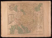
Electorate of Brunswick-Luneburg with its dependencies
Description:
Imperfect: torn along fold, with some loss of text. Sheet measures 75.0 x 62.4 cm. No. 30 of 34 maps bound together., Inset map: Plan of the battle of Minden on the 1st of August 1759., Prime meridian: Ferro., and Relief shown pictorially.
Bar scales given in "German miles 15 to a degree" and "English statute miles 69 & 1/2 to a degree"., Prime meridian: Ferro., Relief shown pictorially., Sheet measures 54.5 x 72.2 cm. No. 29 of 34 maps bound together., Title of inset map: East-Frieseland, lordship of Jever and the counties of Oldenburg and Delmenhorst., and Watermark.
Publisher:
Thomas Jefferys,
Subject (Geographic):
Lower Saxony (Germany)--Maps--Early works to 1800 and North Rhine-Westphalia (Germany)--Maps--Early works to 1800
Hoüel, Jean-Pierre-Laurent, 1735-1813 Jefferys, Thomas, d. 1771
Published / Created:
[1768]
Call Number:
1977 Folio 177
Image Count:
2
Resource Type:
Maps, Atlases & Globes
Description:
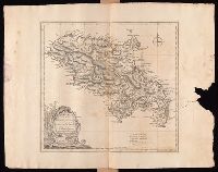
Bar scales given in "British miles 69 to a degree" and "British and French sea leagues 20 to a degree"., Imperfect: torn and mutilated on the right side, with no loss of text. Sheet measures 44.5 x 56.5 cm. No. 13 of 34 maps bound together., Prime meridian: Ferro., Relief shown by hachures; depths by soundings., Shows habitation or plantations, sugar works, oxen and water mills, observations points, etc., and Watermark.
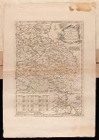
Plan of the country where the Prussian army gained a victory over the Austrians, Oct. 1, 1756. and Routes of the Prussian Armies into Bohemia
Description:
Bar scales given in "English miles 69 1/2 to a degree," "German miles 15 in a degree," and "Bohemian or gr ms. of Silesia 12 in a Deg.", Prime meridians: London and Ferro., Sheet measures 50.3 x 34.6 cm. No. 14 of 34 maps bound together., and With inset map: Plan of the country where the Prussian army gained a victory over the Austrians, Oct. 1, 1756.
Publisher:
T. Jeffreys,
Subject (Geographic):
Bohemia (Czech Republic)--Maps--Early works to 1800
Subject (Topic):
Seven Years' War, 1756-1763--Maps--Early works to 1800
"Emanl. Bowen sculp.", Insets: Plan of the Harbours of Ferrol and the Groyne -- Plan of St Sebastian -- Plan of Barcelona -- Plan of the Bay and City of Cadiz -- Plan of the Town and Fortifications of Gibralter -- Plan of the Town, Harbour & Fortifications of Port Mahone -- Plan of Dunkirk as given to the Duke of Ormond -- Plan of Dunkirk as demolished with the Projected Port of Mardyke., Relief shown pictorially., and Sheet measures 72.2 x 55.5 cm. No. 21 of 34 maps bound together.
Publisher:
T. Jefferys,
Subject (Topic):
Coasts--Europe, Western--Maps--Early works to 1800 and Nautical charts--Europe, Western--Early works to 1800