Skip to search
Skip to main content
Skip to first result
Search
You Searched For
Publication Place
[Paris] :
New Search
Search Results
Creator:
Published / Created:
[1839]
Call Number:
2012 +159
Image Count:
43
Alternative Title:
Histoire de Monsieur Lajaunisse. and Mr. Lajaunesse.
Description:
Cover title: Mr. Lajaunesse. and Imperfect?: leaf 35 wanting; without the cover title. The numbered leaves are preceded by a leaf listing on [2] p. "Publications de la maison Aubert et cie Galerie Véro-Dodat" and an illustrated title leaf.
Publisher:
Chez Aubert,
Subject (Topic):
Caricature--France
Found in:
Beinecke Rare Book and Manuscript Library > Histoire de Mr. Lajaunisse.
Creator:
Published / Created:
[192-?]
Call Number:
4894 1905
Container / Volume:
BRBL_00267
Image Count:
1
Resource Type:
Maps, Atlases & Globes
Description:
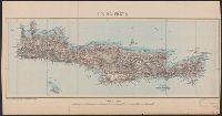
"Prix 1f." and Relief shown by shading. Depths shown by soundings and bathymetric tints.
Publisher:
Service géographique de l'Armée,
Subject (Geographic):
Crete (Greece)--Maps
Found in:
Beinecke Rare Book and Manuscript Library > Ile de Crète [cartographic material] / dessiné et héliogravé au Service géographique de l'Armée.
Creator:
Published / Created:
[1778?]
Call Number:
30 800
Container / Volume:
BRBL_00032B
Image Count:
1
Resource Type:
Maps, Atlases & Globes
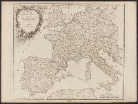
Description:
Colored in outline., Ornamental cartouche signed "Groux.", and Relief shown pictorially.
Publisher:
[Fortin],
Subject (Geographic):
Europe--History--392-814--Maps--Early works to 1800. and Europe--Maps--Early works to 1800.
Subject (Name):
Charlemagne,--Emperor,--742-814--Maps--Early works to 1800. and Groux, Charles Jacques
Found in:
Beinecke Rare Book and Manuscript Library > Imperium Caroli Magni occidentis Imperatoris : complectens Galliam, Marcam Hispanicam, Baleares insulas, Corsicam, Italiam (Vulturnum usque et Ausidum fluv[ius]), Istriam, Liburniam, Dalmatiam, Rhaetiam, Vindeliciam, Noricum, et quidquid Germaniae à Rheno ad Oderam usque et Mare Balticum, protenditur / ‡c autore D. Robert de Vaugondy, Geographo.
Creator:
Published / Created:
1780
Call Number:
49 1780
Container / Volume:
BRBL_00267
Image Count:
1
Resource Type:
Maps, Atlases & Globes
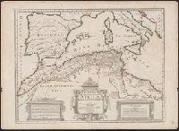
Description:
Relief shown pictorially., Stamp on verso: 154., and Watermarks.
Publisher:
Chez Dezauche,
Subject (Geographic):
Africa, North--Maps
Subject (Name):
Liébaux, Jean Baptiste, engraver
Subject (Topic):
Ecclesiastical geography--Africa, North--Maps--Early works to 1800
Found in:
Beinecke Rare Book and Manuscript Library > In notitiam ecclesiasticam Africæ tabula geographica [cartographic material] / Auctore G. de l'Isle ; Joan. Bap. Liébaux inv. et sculp.
Published / Created:
[1700?]
Call Number:
38 1659
Container / Volume:
BRBL_00151
Image Count:
1
Resource Type:
Maps, Atlases & Globes
Description:
Index.
Publisher:
A. Perelle fecit.,
Subject (Geographic):
France--Maps--Early works to 1800
Found in:
Beinecke Rare Book and Manuscript Library > L'Isle de la Conference ou la Paix generalle a esté conclue entre la France et l'Espagne le 7. Novemb. 1659.
Creator:
Published / Created:
[1751?]
Call Number:
3614 1751
Container / Volume:
BRBL_00135
Image Count:
1
Resource Type:
Maps, Atlases & Globes
Description:
"Guill. Delahaye, sculpsit.", Ornamental cartouche., Relief shown pictorially., Sheet 50.6 x 67.1 cm., and Stamp on verso: 80.
Publisher:
[publisher not identified],
Subject (Geographic):
Prussia (Germany)--Maps--Early works to 1800, Prussia, East (Poland and Russia)--Maps--Early works to 1800, and Prussia, West (Poland)--Maps--Early works to 1800
Subject (Name):
Haye, G. de la and Hughes, Thomas Lowe,--1925---Ownership
Found in:
Beinecke Rare Book and Manuscript Library > La Prusse divisée en Prusse Royale, et Prusse Ducale : laquelle a eté érigée en Royaume par l'Empereur Leopold en faveur de Frederic I. Elect. de Brandebourg couronée en Janvier 1701 / par le Sr. Robert, géographe.
Creator:
Published / Created:
1736
Call Number:
339 1736
Container / Volume:
BRBL_00090
Image Count:
4
Resource Type:
Maps, Atlases & Globes
Alternative Title:
Comté de Namur, partie de l'evesché de Liege, du Luxembourg, &c.
Description:
"Avec privilége de sa Majesté"., Imprint below scale bar: "A Paris joignant les Grands Augustins, aux deux Globes, avec privilége du Roy, 1705.", Manuscript numbers of verso of sheets: 77, 78, 79, 80., Relief shown pictorially., and Watermarks.
Publisher:
[Alexis Hubert Jaillot],
Subject (Geographic):
Luxembourg (Belgium)--Maps--Early works to 1800.
Found in:
Beinecke Rare Book and Manuscript Library > Le Duché de Luxembourg divisé en quartier Walon et Allemand : dans chacun desquels sont diviséz les seigneuries, prevostés et comtés, le duché de Bouillon, le comté de Namur et le pays entre Sembre et Meuse / dédié au Roy par son tres humble, tre
Published / Created:
1916
Call Number:
11hc 1916HB
Container / Volume:
BRBL_00010C
Image Count:
1
Resource Type:
Maps, Atlases & Globes
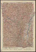
Alternative Title:
Lorraine et Alsace
Description:
"Front au 1er. Janvier 1916.", "Supplément à l'illustration.", Ms. note outside bottom right margin "L'illus MY'19"., and Shows location of Western Front, railways, roads, canals, borders, and fortifications.
Publisher:
G. Peltier,
Subject (Geographic):
France--Maps
Subject (Topic):
World War, 1914-1918--Maps
Found in:
Beinecke Rare Book and Manuscript Library > Le Front = Lorraine et Alsace / dressé et dessiné́ par G. Peltier.
Published / Created:
1916
Call Number:
11hc 1916H
Container / Volume:
BRBL_00010C
Image Count:
1
Resource Type:
Maps, Atlases & Globes
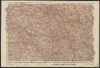
Description:
"Front au 1er. Janvier 1916.", "Supplément à l'illustration.", Ms. note outside bottom right margin "L'illus My'19"., and Shows location of Western Front, railways, roads, canals, borders, and fortifications.
Publisher:
G. Peltier,
Subject (Geographic):
France--Maps
Subject (Topic):
World War, 1914-1918--Maps
Found in:
Beinecke Rare Book and Manuscript Library > Le Front de Soissons a Nancy / dressé et dessiné́ par G. Peltier.
Creator:
Published / Created:
1873
Call Number:
38 P21 1873A
Container / Volume:
BRBL_00163
Image Count:
1
Resource Type:
Maps, Atlases & Globes
Description:
Inset: Fortifications et environs de Paris.
Publisher:
Gravé par A. Martin,
Subject (Geographic):
Paris (France)--Maps
Found in:
Beinecke Rare Book and Manuscript Library > Le Plan de Paris de 1873 [cartographic material] / par le dr. Ermète Pierotti.
Branch:v1.61.8 ,Deployed:2024-06-20T11:15:15-04:00