Ed. statement appears on Northern Hemisphere map only., No. 3 of 43 maps bound together in composite atlas., Relief shown pictorially., Scale [ca. 1:41,000,000. At equator]., and Shows tracks of various ocean voyages.
Publisher:
William Faden
Subject (Geographic):
Northern Hemisphere --Maps --Early works to 1800 and Southern Hemisphere --Maps --Early works to 1800
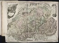
Also appeared in Faden's [General atlas. London : William Faden, 1811?]., Includes "Vue de la Vallee de Chamouny et des glaciers du Cote du Midi, prise de l'eglise de Chamouny en 1742," "Section des principales montagnes a l'est-sud-est, et au Sud de Geneve telles qu'on les voit de la plaine de cette ville," descriptive text, illustrated cartouches., No. 19 of 43 maps bound together in composite atlas., Prime meridian: Ferro., Relief shown pictorially., and Scale [ca. 1:404,000].
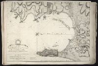
Also appeared in Faden's [General atlas. London : William Faden, 1811?]., In cartouche above title: The Roman obsidional crown, Parcere subjectis et debellare superbos., No. 15 of 43 maps bound together in composite atlas., Oriented with north toward right., Relief shown by hachures; depths by soundings., Scale [ca. 1:24,700]., and Shows ocean currents, buildings, forts, fields, magnetic declination, etc.
Publisher:
William Faden
Subject (Geographic):
Gibraltar --History --Siege, 1779-1783 --Maps --Early works to 1800, Gibraltar --Maps --Early works to 1800, and Gibraltar, Bay of (Spain) --Maps --Early works to 1800
Kitchin, Thomas, d. 1784, creator Sayer, Robert, 1725-1794, publisher
Published / Created:
1787 January 1
Call Number:
1982 Folio 10
Image Count:
2
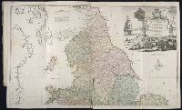
Alternative Title:
England & Wales and South Britain
Description:
Imperfect: both sheets torn along some folds, with some loss of text., Inset map: Isles of Scilly., London meridian., No. 5 of 43 maps bound together in composite atlas., Relief shown pictorially and by hill shading., and Scale [ca. 1:575,000].
Publisher:
R. Sayer
Subject (Geographic):
England --Maps --Early works to 1800 and Wales --Maps --Early works to 1800
Delarochette, L. (Louis), 1731-1802, creator Faden, William, 1749-1836
Published / Created:
1782 March 20
Call Number:
1982 Folio 10
Image Count:
1
Description:
No. 37 of 43 maps bound together in composite atlas., Place names in Dutch; pictorial relief. "The red line describes the route of the British Army from its landing at Simons Baay to Cape Town.", and Scale [ca. 1:528 000].
Publisher:
W. Faden
Subject (Geographic):
Cape of Good Hope (South Africa) --Maps --Early works to 1800
Imperatorskaia akademia nauk (Russia) Kitchin, Thomas, d. 1784, creator Sayer, Robert, 1725-1794
Published / Created:
1788 May 1
Call Number:
1982 Folio 10
Image Count:
2
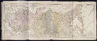
Alternative Title:
Asiatic part of the Russian empire : from the maps published by the Imperial Academy of St. Petersburg with the new discoveries of Captn. Cook &c
Description:
Also appeared in Kitchin's General atlas describing the whole universe. London : Printed R. Sayer and J. Bennet, 1780., No. 25 of 43 maps bound together in composite atlas., Prime meridian: Ferro., Relief shown pictorially., Scale [ca. 1:8,000,000]., Sheets mounted together to form 1 sheet., and Shows vegetation, sailing and explorers tracks, etc.
British & Spanish territories according to the treaty of 1784
Description:
For a description of the second and third states see Stevens and Tree, Comparative Cartography, Map Collectors' Circle (1967)., Includes historical notes and a color key., Includes text., No. 40 of 43 maps bound together in composite atlas., Prime meridian: London., Relief shown pictorially., Scale [ca. 1:6,750,000]., and Shows numerous boundary changes.
Publisher:
Willm. Faden
Subject (Geographic):
United States --Boundaries --Maps --Early works to 1800 and United States --Maps --Early works to 1800