Bar scales in Milliaria Germanica communia 15 in uno gradu, Milliaria Gallica magna, sive horae itineris, and milliaria Italica magna 60 in uno gradu., No. 19 of 69 maps bound together in composite atlas., Relief shown pictorially., and Scale [ca. 1:860 000].
Publisher:
[Frederik de Wit?]
Subject (Geographic):
Tuscany (Grand Duchy) --Maps --Early works to 1800
[Atlas factice of 42 maps, produced by the Homann Erben firm]
Image Count:
1
Alternative Title:
Etats de l’Eglise & du Grand Duche de Toscane, Etats de l’Eglise & du Grand Dvche de Toscane, and Status Ecclesiastici nec non Magni Ducatus Toscanae nova tabula geographica
Publisher:
Curantibus Homannianis Heredibus
Subject (Geographic):
Papal States --Maps --Early works to 1800 and Tuscany (Italy) --Maps --Early works to 1800
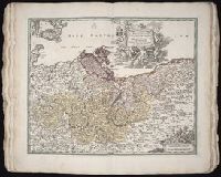
Bar scales given in milliaria Germanica communia and milliaria Gallica communia., Ferro meridian., No. 54 of 69 maps bound together in composite atlas., Relief shown pictorially., and Scale [ca 1:1 330 000].
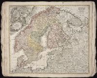
Bar scales in Mill. Germanica Comm 15 in uno gradu and Mill. Gallica et Livonica quae horae itineris., Ferro meridian., No. 38 of 69 maps bound together in composite atlas., Relief shown pictorially., and Scale [ca. 1:910 000].
Subject (Geographic):
Estonia --Maps --Early works to 1800 and Latvia --Maps --Early works to 1800