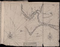
Jovrnal ou Description dv merveillevx voyage de Gvillavme Schovten, hollandois natif de Hoorn
Image Count:
1
Description:
Bound in facing p. 20., Map has several small brown marks on both the recto and verso as well as a larger one in the center that can be seen on both the recto and verso., and Scale not given.
Subject (Geographic):
Horn, Cape (Chile), Le Maire Strait (Argentina), and Tierra del Fuego (Argentina) --Maps --Early works to 1800
Subject (Name):
Schouten, Willem Corneliszoon, d. 1625
Collection Created:
A Amstredam : Chez Harman Ianson, marchand libraire, demeurant en la VVarmoes-straet, a le Sereine, 1619
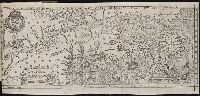
Journal ou relation exacte du voyage de Guill Schouten
Image Count:
1
Alternative Title:
Description du nouveau pasage vers le zud du destroit de Magellan, de couuert et passe en l’an 1616 par Guillaume Schouten de Hoorn Holl
Description:
A few small areas of staining can be seen on verso., Bound in after p. 46., Mutilated with some loss of text., and Scale not given.
Subject (Geographic):
Horn, Cape (Chile) --Early works to 1800, Le Maire Strait (Argentina) --Early works to 1800, and Magellan, Strait of (Chile and Argentina) --Early works to 1800
Subject (Topic):
Oceania --Discovery and exploration --Early works to 1800 and Voyages around the world --Early works to 1800
Collection Created:
A Paris : chez M. Gobert, au Palais en la gallerie des prisonniers, et les cartes, chez M. Tauernier, graueur du roy, demeurant au pont Marchand, 1618
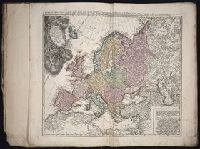
Hase, Johann Matthias, 1684-1742 Homann Erben (Firm)
Published / Created:
1746
Call Number:
1975 Folio 31
Collection Title:
[Atlas factice of 42 maps, produced by the Homann Erben firm]
Image Count:
1
Alternative Title:
Ducatus Silesiae tabula altera superiorem Silesiam exhibens and Haute Silesie, qui comprend les Principautes de Neise, de Munsterberg, de Laegerndorf, de Troppau, d’Oppeln, de Ratibor, de Teschen dessinee par les Heritiers de Homann, l’an 1746
Publisher:
Homann Erben
Subject (Geographic):
Silesia, Upper (Poland and Czech Republic) --Maps --Early works to 1800
Hase, Johann Matthias, 1684-1742 Homann Erben (Firm) Mayer, Tobias, 1723-1762
Published / Created:
1745
Call Number:
1975 Folio 31
Collection Title:
[Atlas factice of 42 maps, produced by the Homann Erben firm]
Image Count:
1
Alternative Title:
Basse Silesie qui comprend les Principautes de Schweidnitz, de Iauer, de Glogau, de Breslau, de Liegnitz, de Brieg, de Wolau, de Oels & de Sagan and Ducatus Silesiae tabula geographica prima inferiorem eius partem
Publisher:
Homann Erben
Subject (Geographic):
Silesia, Lower (Poland and Germany) --Maps --Early works to 1800
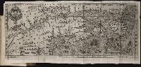
Bound in after p. 224., Depicts coat of arms of Henry IV of France., In pencil on bottom left corner: 224., Map has several small brown marks on both the recto and verso., Map has small hole in left-most section just above a depiction of a pine cone., and Scale [ca. 1:9,428,600].
Subject (Geographic):
Acadia --Early works to 1800, America --Discovery and exploration --French --Early works to 1800, New France --Discovery and exploration --Early works to 1800, and New France --Maps --Early works to 1800
Subject (Name):
Villegaignon, Nicolas Durand de, 1510-1571?
Subject (Topic):
Indians of North America --Early works to 1800 and Indians of North America --Nova Scotia --Early works to 1800
Histoire de la Nouvelle France : contenant les navigations, decouvertes, & habitations faites par
Image Count:
1
Alternative Title:
Figure de la terre neuve, grande ri
Description:
Bound in after p. 236., Depicts coat of arms of Henry IV of France., In pencil on verso: 236., Map has one small hole along fold of second panel at the top., Map has several small brown marks, most notably on the verso., and Scale [ca. 1:9,428,600].
Subject (Geographic):
Acadia --Early works to 1800, America --Discovery and exploration --French --Early works to 1800, New France --Discovery and exploration --Early works to 1800, and New France --Maps --Early works to 1800
Subject (Name):
Millot, Jean, b. 1582, printer, Swelinck, Jan, engraver
, and Villegaignon, Nicolas Durand de, 1510-1571?
Subject (Topic):
Indians of North America --Early works to 1800 and Indians of North America --Nova Scotia --Early works to 1800
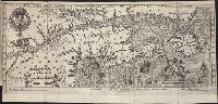
Bound in first after p. [48]., Depicts coat of arms of Henry IV of France., Drawn by Marc Lescarbot, made by Jan Swelinc, published by I. Millot., Immediately following Extraict du Privilege du Roy., Map has several small brown marks on both the recto and verso., Scale [ca. 1:9,428,600]., and Teaching resource: Professor John Mack Faragher, History 141: The American West.
Subject (Geographic):
Acadia --Early works to 1800, America --Discovery and exploration --French --Early works to 1800, New France --Discovery and exploration --Early works to 1800, and New France --Maps --Early works to 1800
Subject (Name):
Millot, Jean, b. 1582, printer, Swelinck, Jan, engraver, and Villegaignon, Nicolas Durand de, 1510-1571?
Subject (Topic):
Indians of North America --Early works to 1800 and Indians of North America --Nova Scotia --Early works to 1800