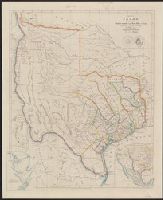
From the Streeter collection., Includes area map and ancillary map of "Plan of Galveston Bay from a ms.", Relief shown by hachures., and Shows 31 counties, notes from Le Grand's survey, various routes, "Fisher & Comp.y" northwest of Austin, "Al Bourgeois d'Orvanne's Grant" west of San Antonio, and names for projected land holdings, "Mr. Kennedy", "Mr. H. Castro", and "Mr. Pierson."
Publisher:
John Arrowsmith,
Subject (Geographic):
Texas--Administrative and political divisions--Maps and Texas--Maps
Subject (Name):
Arrowsmith, John, 1790-1873. London atlas of universal geography
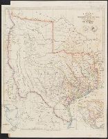
Appears in Arrowsmith's London atlas of universal geography., From the Streeter collection., Includes area map and ancillary map of "Plan of Galveston Bay from a ms.", Library's copy annotated in pencil., Relief shown by hachures., and Shows 31 counties, notes from Le Grand's survey, and various routes.
Publisher:
John Arrowsmith,
Subject (Geographic):
Texas--Administrative and political divisions--Maps and Texas--Maps
Subject (Name):
Arrowsmith, John, 1790-1873. London atlas of universal geography
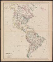
"44.", Appears in author's The London atlas of universal geography, 1840., From the Streeter collection., Inset: Mexico, shewing its connection with the ports of Acapulco, Vera Cruz, & Tampico. Scale [ca. 1:3,325,000]., Library's copy annotated in pencil on verso to highlight details of map and compare to Stephen Austin's map of 1830., and Relief shown by hachures.
Publisher:
J. Arrowsmith,
Subject (Geographic):
Mexico--Maps and Southwestern States--Maps
Subject (Name):
Arrowsmith, John, 1790-1873. London atlas of universal geography and Streeter, Thomas W.--(Thomas Winthrop),--1883-1965--Ownership