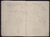
The West-India atlas: or, A compendious description of the West-Indies: illustrated with forty
Image Count:
1
Resource Type:
Maps, Atlases & Globes
Alternative Title:
The harbours of Kingston and Port Royal and The windward passage, with the several passages, from the...east end of Cuba, and the north part of St. Domingo.
Description:
With two inset maps.
Subject (Geographic):
Cuba. and Santo Domingo (Dominican Republic)
Subject (Topic):
Nautical charts
Collection Created:
London, Printed for Robert Sayer and John Bennett, Fleet-Street, 1775
The English pilot: describing the West-India navigation, from Hudson's-Bay to the river Amazones
Image Count:
1
Resource Type:
Maps, Atlases & Globes
Subject (Geographic):
Atlantic Ocean --Maps --Early works to 1800, Casco Bay (Me.) --Maps --Early works to 1800, Maine --Maps --Early works to 1800, and New England --Maps --Early works to 1800
Subject (Topic):
Navigation --Early works to 1800, Pilot guides --Atlantic Coast (U.S.) --Early works to 1800, and Pilot guides --Caribbean Area --Early works to 1800
Collection Created:
London : Printed for W. and J. Mount, T. Page and son, on Tower-Hill, MDCCLIX [1759]
Kingdom of Denmark in which are the islands of Seland and of Fyonie the dukedom of Sleswick and the Diocess of Rypen ... described by Sanson, corrected and amended by William Berry
Description:
Bar scales in Italian miles, common leagues of Germany, great leagues of Germany of common leagues of Sweden, and common leagues of France., Dedicated To the most serene and most sacred majesty Charles II ... by William Berry., Ferro meridian., No. 42 of 69 maps bound together in composite atlas., Relief shown pictorially., and Scale [ca. 1:980 000].
Publisher:
Sold by William Berry at the sign of the Globe between Charing-Cross and White-Hall
Kingdom of France divided into all its provinces, comprehended under twelve generall governments viz. ... described by Sanson, corrected and amended by William Berry
Description:
Bar scales given in Italian miles, common leagues of France, great leagues of France, common leagues of Germany, great leagues of Germany, English miles, and common leagues of Spain., Ms. mathematical computations on right margin., No. 12 of 69 maps bound together in composite atlas., Relief shown pictorially., Scale [ca. 1:2 100 000]., and With dedication To the most serene and most sacred Majesty Charles II ... from William Berry.
Publisher:
Sold by William Berry at the sign of the Globe between Charing-Cross and White-Hall
Subject (Geographic):
Europe, Central --Maps --Early works to 1800 and France --Maps --Early works to 1800
Kingdom of Hungary and the states that have been subject and depended on that crown viz Transilvania, Moldavia, Valachia, Croacia, Bosnia, Dalmatia, Servia, Bulgaria ... described by Sanson, corrected and amended by William Berry
Description:
Bar scales in Italian miles, common leagues of France, common leagues or great leagues of Poland, leagues of Hungary, and leagues that are of one hours travelling., Dedicated To the most serene and most sacred majesty Charles II ... by William Berry., Ferro meridian., No. 25 of 69 maps bound together in composite atlas., Relief shown pictorially., Scale [ca. 1:2 100 000]., and Shows Hungary, Bulgaria, Romania and the northern part of the Balkan Peninsula.
Publisher:
Sold by William Berry at the sign of the Globe, between Charing-Cross, and White-Hall
Subject (Geographic):
Balkan Peninsula --Maps --Early works to 1800, Hungary --Maps --Early works to 1800, and Romania --Maps --Early works to 1800