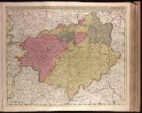
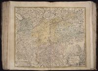
Appears in Valk and Schenk's Atlantis sylloge compendiosa, ca. 1702., Backed with paper. Ms. no. in upper right corner: 24. Sheet measures 53.7 x 62.7 cm. No. 24 of 87 maps bound together., Bar scales given in "milliaria Germanica communia" and "milliaria Gallica communia"., Prime meridian: Ferro., Relief shown pictorially., and Watermark.
Publisher:
Gerard Valck,
Subject (Geographic):
Brandenburg (Germany)--Maps--Early works to 1800., Saxony (Germany)--Maps--Early works to 1800., Saxony-Anhalt (Germany)--Maps--Early works to 1800., and Thuringia (Germany)--Maps--Early works to 1800.
Subject (Name):
Schenk, Peter, 1660-1718 or 1719. Atlantis sylloge compendiosa., Valck, G. (Gerard), 1651 or 1652-1726. Atlantis sylloge compendiosa., and Valck, Leonard, 1675-1746.
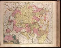
Appeard in Gerard Valck and Peter Schenk's Atlantis sylloge, ca. 1702., Backed with paper. Ms. no. "28" in upper left-hand corner. Sheet measures 53.7 x 63.0 cm. No. 28 of 87 maps bound together., Bar scales given in "milliaria Germanica" and "milliaria Gallica"., Prime meridian: Ferro., Relief shown pictorially., and Watermark.
Publisher:
Edente Gerardô Valck,
Subject (Geographic):
Baden-Württemberg (Germany)--Maps--Early works to 1800.
Subject (Name):
Schenk, Peter, 1660-1718 or 1719. Atlantis sylloge compendiosa. and Valck, G. (Gerard), 1651 or 1652-1726. Atlantis sylloge compendiosa.
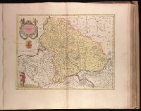
Backed with paper. Illegible ms. note in pencil on map. Ms. no. "55" in upper-right corner. Sheet measures 53.5 x 63.2 cm. No. 50 of 87 maps bound together., Bar scale given in "milliaria Gallica communia"., Prime meridian: Ferro., Relief shown pictorially., Variant with shield below title filled in., and Watermark.
Publisher:
Apud Guiljemum et Joanne[m] Blaeu,
Subject (Geographic):
Île-de-France (France)--Maps--Early works to 1800. and Picardy (France)--Maps--Early works to 1800.
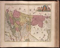
"Cum privil.", "I. Bormeester, eccu.", Bar scales given in "Gemene Duÿtsche Mÿlen 15 in een Graedt" and "Uren gaens de 4 maken 3 Mÿlen"., BEIN 1973 Folio 18: Backed with paper. Ms. no. "41" in upper-right corner. Sheet measures 53.6 x 62.7 cm. No. 40 of 87 maps bound together., Inset: De resterende Eÿlanden van Hollant alhier bÿgevoecht., North oriented to the upper-right., Prime meridian: Ferro., Relief shown pictorially., and Title in Latin; place names in Dutch.
Bar scales given in "mill. Germanica," "mill. Gallica," and "mill. Italica.", Includes illustration "Die Vestung Kofel.", Ms. no. on verso: LII. Sheet measures 53 x 65.4 cm., and Relief shown pictorially.
[Atlas factice of 50 maps, primarily by Johann Baptist Homann and/or issued by the Homann Erben
Image Count:
1
Description:
Bar scales given in "mill. Germanica," "mill. Gallica," and "mill. Italica.", Includes illustration "Die Vestung Kofel.", Relief shown pictorially., and Sheet measures 54.3 x 64.5 cm. No. 30 of 50 maps bound together.
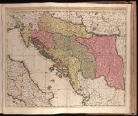
Backed with paper. Ms. no. "77" in upper right corner. Sheet measures 53.6 x 62.5 cm. No. 71 of 87 maps bound together., Bar scales given in "milliaria Hungarica" and "milliaria Germanica.", Covers Croatia, Bosnia and Hercegovina, Serbia, Montenegro and portions of Italy, Albania, Greece, Macedonia and Hungary., In Latin with place names in Italian., and Relief shown pictorially.
"Cum privilegio ord. Holl. et West-frisiae"., Backed with paper. Ms. no. "8" in upper right-hand corner. Sheet measures 53.4 x 62.6 cm. No. 7 of 87 maps bound together., Bar scales given in "milliaria Germanica" and "mill. Danica et Suecia"., Prime meridian: Ferro., Relief shown pictorially., and Watermark.
Publisher:
[Peter Schenk],
Subject (Geographic):
Denmark--Maps--Early works to 1800. and Germany, Northern--Maps--Early works to 1800.
Dimidia Tribvs Manasse ultra Jordanem, tribus Neptalim et partes orientales Tribuum Zabvion et Isachar
Description:
Appears in Jansson's historical atlas editions from 1652-1684 and in his Accuratissima orbis antiqui delineatio. From 1653 on, this work is known under the name of Hornius, who wrote the text and compiled all the maps for the atlases--(Koeman-Krogt. 1:601-1:607)., Coordinates not present on map and are approximated., Inset: Peregrinatio Abrahae., Map indexed with grid lines and alphabet letters P-R at top., Oriented with north toward the left., Printed on one and a half sheets., Relief shown pictorially., and Watermark. Manuscript numbers in upper left and right corners: 46. No. 4 of 6 maps housed together.
Publisher:
[Jan Jansson],
Subject (Geographic):
Palestine--History--To 70 A.D.--Maps--Early works to 1800. and Palestine--Maps--Early works to 1800.