Skip to search
Skip to main content
Skip to first result
Search
You Searched For
Format
cartographic
Genre
Maps
New Search
Search Results
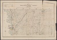
Published / Created:
1914
Call Number:
764 P44 1914
Container / Volume:
BRBL_00459
Image Count:
1
Resource Type:
Maps, Atlases & Globes
Description:
"August, 1914". and "S.W. Dohanian, fecit."
Publisher:
Walker LIth. & Pub. Co.,
Subject (Geographic):
Petersham (Mass.)--Maps
Found in:
Beinecke Rare Book and Manuscript Library > Map of Petersham, Mass. ; showing town roads, wood roads, and trails, for a portion of the Township / prepared and published by The Village Improvement Society from Existing Surveys and Original Transverses.
Creator:
Published / Created:
c1891.
Call Number:
774 P53 1891
Collection Title:
Rand McNally and Co.'s Indexed atlas of the world.
Container / Volume:
BRBL_00500
Image Count:
1
Resource Type:
Maps, Atlases & Globes
Alternative Title:
Philadelphia and vicinity. and Rand McNally & Co.'s new business atlas map of Philadelphia.
Description:
"90, 91.", At head of title and top of map: Rand McNally & Co.'s indexed Atlas of the world., Includes index of piers and their ownership on Delaware River., Inset: Philadelphia and vicinity. Scale [ca. 1:120,000]., and On verso: [part of gazetteer listing for Pe
Publisher:
Rand McNally,
Subject (Geographic):
Philadelphia (Pa.)--Maps and Philadelphia Metropolitan Area (Pa.)--Maps
Subject (Name):
Rand McNally and Company. Rand McNally & Co.'s indexed atlas of the world
Subject (Topic):
Harbors--Pennsylvania--Philadelphia Metropolitan Area--Maps
Found in:
Beinecke Rare Book and Manuscript Library > Map of Philadelphia / Rand McNally & Co., Engravers.
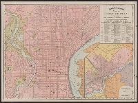
Published / Created:
1877
Call Number:
774 P53 1877
Container / Volume:
BRBL_00500
Image Count:
1
Resource Type:
Maps, Atlases & Globes
Description:
Printed on cloth measuring 70 x 61 cm.
Subject (Geographic):
Philadelphia (Pa.)--Maps
Found in:
Beinecke Rare Book and Manuscript Library > Map of Philadelphia.
Published / Created:
1895
Call Number:
761 P837 1895
Container / Volume:
BRBL_00449
Image Count:
1
Resource Type:
Maps, Atlases & Globes
Description:
Includes index. and Shows city districts, radial distances from City Hall, and railroads.
Publisher:
Thurston Report ,
Subject (Geographic):
Portland (Me.)--Maps
Found in:
Beinecke Rare Book and Manuscript Library > Map of Portland, Me. and vicinity / published by The Thurston Report for the Portland Directory.
Published / Created:
c1901.
Call Number:
846gmb P837 1901
Container / Volume:
BRBL_00624
Image Count:
2
Resource Type:
Maps, Atlases & Globes
Description:
"Bushong & Co., map engravers, Portland, Oregon" on verso., Map has public land (township, range, and section) grid., On verso: Map of Piedmont [addition], Portland, Oregon., and Shows city boundary, subdivisions, additions, streets, and railroads.
Publisher:
C.H. Crocker Co.,
Subject (Geographic):
Portland (Or.)--Maps
Subject (Name):
Bushong & Co
Subject (Topic):
Real property--Oregon--Portland--Maps
Found in:
Beinecke Rare Book and Manuscript Library > Map of Portland, Oregon.
Creator:
Published / Created:
[1870]
Call Number:
815 P85 1870
Container / Volume:
BRBL_00560
Image Count:
1
Resource Type:
Maps, Atlases & Globes
Description:
Relief shown by hachures. and Shows timber lands, swamp lands, railroads, and townships and sections.
Publisher:
David Tostevin : and L.P. Judson,
Subject (Geographic):
Pottawattamie County (Iowa)--Maps
Subject (Name):
Judson, L. P and W. Endicott & Co
Found in:
Beinecke Rare Book and Manuscript Library > Map of Pottawattamie County, Iowa 1870.
Published / Created:
192-]
Call Number:
765 P94 192X
Container / Volume:
BRBL_00464
Image Count:
1
Resource Type:
Maps, Atlases & Globes
Publisher:
s.n.,
Subject (Geographic):
Providence (R.I.)--Administrative and political divisions--Maps
Found in:
Beinecke Rare Book and Manuscript Library > Map of Providence showing representative districts.
Creator:
Published / Created:
[1915?]
Call Number:
765 P94 1915
Container / Volume:
BRBL_00464
Image Count:
1
Resource Type:
Maps, Atlases & Globes
Description:
Shows street names and parks, civic institutions, etc.
Publisher:
Walker Lith. & Pub. Co.,
Subject (Geographic):
Providence (R.I.)--Maps
Subject (Topic):
Streets--Rhode Island--Maps
Found in:
Beinecke Rare Book and Manuscript Library > Map of Providence, Rhode Island.
Published / Created:
192-]
Call Number:
765 P94 192XB
Container / Volume:
BRBL_00464
Image Count:
1
Resource Type:
Maps, Atlases & Globes
Publisher:
s.n.,
Subject (Geographic):
Providence (R.I.)--Administrative and political divisions--Maps
Found in:
Beinecke Rare Book and Manuscript Library > Map of Providence, showing senatorial districts and representative districts comprising each.
Branch:v1.61.8 ,Deployed:2024-06-20T11:15:02-04:00