Skip to search
Skip to main content
Skip to first result
Search
You Searched For
Extent of Digitization
Completely digitized
Resource Type
Maps, Atlases & Globes
Language
English
Publication Place
Paris :
New Search
Search Results
Published / Created:
1919
Call Number:
11hcf 1919-15
Container / Volume:
BRBL_00010J
Image Count:
6
Resource Type:
Maps, Atlases & Globes
Description:
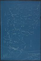
Sheets 1-2: blueprints, sheet 3-4: outline prints, sheet 5: negative line print, sheet 6: black-line print. and Shows department seat, boundaries, and battle lines.
Publisher:
The Commission,
Subject (Geographic):
Aisne (France)--Maps
Found in:
Beinecke Rare Book and Manuscript Library > American Commission to Negotiate Peace : War Damages in Allied Countries, Base map of Aisne Department / taken from File no. 74-A-3. Drawn by R.A.K. , checked by W.H.J. , 7th February, 1919.
Published / Created:
1919
Call Number:
11hcf 1919C-9
Container / Volume:
BRBL_00010V
Image Count:
5
Resource Type:
Maps, Atlases & Globes
Description:
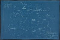
In bottom right: Drawn by R.A.K., Checked by W.H.J. ; No. 343-A-5. and Shows department, arrondissement and canton seats and boundaries, battle lines.
Publisher:
The Commission,
Subject (Geographic):
Marne (France)--Maps
Found in:
Beinecke Rare Book and Manuscript Library > Base Map of Marne Department : Taken from File 74-A-3 / American Commision to Negotiate Peace, War Damages in Allied Countries.
Published / Created:
1919
Call Number:
11hcf 1919C-10
Container / Volume:
BRBL_00010S
Image Count:
6
Resource Type:
Maps, Atlases & Globes
Description:
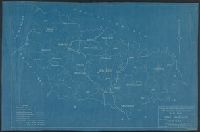
In bottom right: Drawn by Hansen, Checked by Jones ; No. 347-A-5. and Shows department, arrondissement and canton seats and boundaries, Battle lines of Sept. 6, 1914; March 20, 1918; and Nov. 11, 1918.
Publisher:
The Commission,
Subject (Geographic):
Meuse (France)--Maps
Found in:
Beinecke Rare Book and Manuscript Library > Base Map of Meuse Department : Taken from File 74-A-3 / American Commision to Negotiate Peace, War Damages in Allied Countries.
Published / Created:
1919
Call Number:
11hcf 1919C-8
Container / Volume:
BRBL_00010V
Image Count:
6
Resource Type:
Maps, Atlases & Globes
Description:
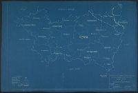
In bottom right: Drawn by S.R., Checked by W.H.J. ; No. 344-A-5. and Shows department, arrondissement and canton seats and boundaries, battle lines.
Publisher:
The Commission,
Subject (Geographic):
Marne (France)--Maps and Seine (France)--Maps
Found in:
Beinecke Rare Book and Manuscript Library > Base Map of Seine et Marne Department: Taken from File No. 115-G-1 / American Commision to Negotiate Peace, War Damages in Allied Countries.
Published / Created:
1919
Call Number:
11hcf 1919C-7
Container / Volume:
BRBL_00010V
Image Count:
6
Resource Type:
Maps, Atlases & Globes
Description:
In bottom right: No. 345-A-5. and Shows department, arrondissement and canton seats and boundaries, national boundaries, battle lines.
Publisher:
The Commission,
Subject (Geographic):
Somme (France)--Maps
Found in:
Beinecke Rare Book and Manuscript Library > Base Map of Somme Department: Taken from File No. 74-A-3 / American Commision to Negotiate Peace, War Damages in Allied Countries.
Published / Created:
1919
Call Number:
11hcf 1919C-11
Image Count:
8
Resource Type:
Maps, Atlases & Globes
Description:
In bottom right: Drawn by S.R., Checked by W.H.J. ; No. 278-A-5. and Shows department, arrondissement and canton seats, national boundaries, battle lines.
Publisher:
The Commission,
Subject (Geographic):
Vosges (France)--Maps
Found in:
Beinecke Rare Book and Manuscript Library > Base Map of Vosges Department: Taken from File No. 74-A-3 / American Commision to Negotiate Peace, War Damages in Allied Countries.
Creator:
Published / Created:
1859
Call Number:
40 1859F
Container / Volume:
BRBL_00201
Image Count:
1
Resource Type:
Maps, Atlases & Globes
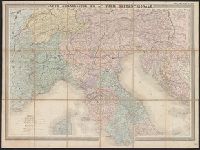
Description:
Cover wanting. Sheet measures 62 x 83 cm., Map of northern Italy showing fortified villas, forts, railroads in service, principal routes and rivers., and Relief shown by hachures.
Publisher:
Publié par E. Andriveau Goujon, Géographe-Editeur ...,
Subject (Geographic):
Italy, Northern--Maps
Subject (Name):
Imprimerie Lemercier et cie
Subject (Topic):
Military maps--Italy
Found in:
Beinecke Rare Book and Manuscript Library > Carte strategique de L'Italie septentrionale [cartographic material] / Imp. Lemercier, Paris.
Creator:
Published / Created:
1919
Call Number:
11hc 1919
Image Count:
2
Resource Type:
Maps, Atlases & Globes
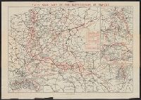
Alternative Title:
Map of the battlefields of France
Description:
"H. Barrère, éditeur-géographe." and Insets: Somme Battle -- Champagne Battle -- Vosges Battle -- Verdun Battle.
Publisher:
Continental Daily Mail,
Subject (Geographic):
France--History--German occupation, 1914-1918--Maps
Subject (Topic):
World War, 1914-1918--France--Maps
Found in:
Beinecke Rare Book and Manuscript Library > Daily Mail map of the battlefields of France.
Published / Created:
1886
Call Number:
38 P21 1886
Container / Volume:
BRBL_00164
Image Count:
2
Resource Type:
Maps, Atlases & Globes
Description:
Made in two colors for guide-service and advertisement of Le Grand Hotel de Paris. and Verso: Western Railway of France, Compagnie Générale Transatlantique with insets: "Environs de Rouen" and "Watering places". Railroad map and prospectus of sights and wat
Publisher:
Hachette,
Subject (Geographic):
France--Maps and Paris (France)--Maps
Found in:
Beinecke Rare Book and Manuscript Library > Grand Hotel: Paris.
Published / Created:
1916
Call Number:
11hcf 1919B-37
Image Count:
1
Resource Type:
Maps, Atlases & Globes
Description:
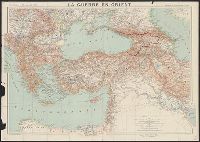
Dessiné et gravé par R. et A. Hausermann.
Publisher:
Augustin Challamel, Éditeur,
Subject (Geographic):
Balkan Peninsula--Maps, Caucasus--Maps, Middle East--Maps, Russia, Southern--Maps, and Turkey--Maps
Subject (Topic):
World War, 1914-1918--Maps
Found in:
Beinecke Rare Book and Manuscript Library > La Guerre en Orient : Extrait de la Carte Générale d'Europe / Marcel Dubois et J.G. Kergomard.
Branch:v1.61.6 ,Deployed:2024-06-12T09:55:19-04:00