Skip to search
Skip to main content
Skip to first result
Search
You Searched For
Resource Type
Maps, Atlases & Globes
Subject (Name)
Rand McNally and Company
Publication Place
Chicago :
New Search
Search Results
Creator:
Published / Created:
1931
Call Number:
844gmb Sa51 1931
Container / Volume:
BRBL_00617
Image Count:
2
Resource Type:
Maps, Atlases & Globes
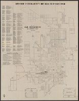
Alternative Title:
101-mile drive on the rim of the world., Map of principal highways in Southern California., and Map of the city of San Bernardino, California, and the "Rim of the world drive" in the San Bernardino Mountains
Description:
Includes index, statistics, and list of public buildings, schools and parks., Publisher from label on verso covering text of "issued by the San Bernardino Chamber of Commerce.", and Text, "Map of principal highways in Southern California," and "[Map of] The 101-mile drive on the rim of the world" (both maps "courtesy of Automobile Club of Southern California") on verso.
Publisher:
Supplied by Rand McNally & Company,
Subject (Geographic):
San Bernardino (Calif.)--Maps
Subject (Name):
Automobile Club of Southern California, Lowe, A. H, and Rand McNally and Company
Subject (Topic):
Roads--California, Southern--Maps and Streets--California--San Bernardino--Maps
Found in:
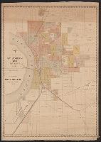
Beinecke Rare Book and Manuscript Library > City of San Bernardino, San Bernardino County, California / A.H. Lowe, City Engineer.
Creator:
Published / Created:
[1898?]
Call Number:
80 1898
Container / Volume:
BRBL_00536
Image Count:
1
Resource Type:
Maps, Atlases & Globes
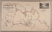
Description:
Includes ill. and text. and Relief shown pictorially.
Publisher:
Rand, McNally & Co.,
Subject (Geographic):
Mississippi River Valley--Discovery and exploration--Maps
Subject (Name):
Rand McNally and Company
Found in:
Beinecke Rare Book and Manuscript Library > Map illustrative of Captain Willard Glazier's voyage of exploration to the source of the Mississippi River / drawn from delineations by his Indian guide, Che-no-wa-ge-sic.
Published / Created:
c1888.
Call Number:
825gme 1888
Container / Volume:
BRBL_00576
Image Count:
1
Resource Type:
Maps, Atlases & Globes
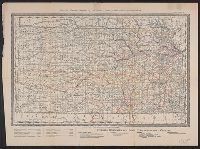
Publisher:
Rand, McNally and Co.,
Subject (Geographic):
Kansas--Maps
Subject (Name):
Kansas. Board of Railroad Commissioners and Rand McNally and Company
Subject (Topic):
Railroads--Kansas--Maps
Found in:
Beinecke Rare Book and Manuscript Library > Map of Kansas / issued by the State Board of Railroad Commissioners.
Creator:
Published / Created:
[1919]
Call Number:
76 1919
Container / Volume:
BRBL_00445
Image Count:
2
Resource Type:
Maps, Atlases & Globes
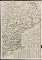
Description:
Indexed.
Publisher:
Rand McNally,
Subject (Geographic):
New England--Maps
Subject (Name):
Rand McNally and Company
Found in:
Beinecke Rare Book and Manuscript Library > Map of New England / issued by United States Railroad Administration.
Creator:
Published / Created:
[1888]
Call Number:
816 Sa23 1888
Container / Volume:
BRBL_00562
Image Count:
1
Resource Type:
Maps, Atlases & Globes
Description:
"Supplement to Daily Herald, New-Year edition, 1888." and Shows numbered lots, additions, and railroads.
Publisher:
Rand McNally & Co.,
Subject (Geographic):
Saint Joseph (Mo.)--Maps
Subject (Name):
Rand McNally and Company
Subject (Topic):
Real property--Missouri--Saint Joseph--Maps
Found in:
Beinecke Rare Book and Manuscript Library > Map of St. Joseph, Mo. and vicinity / by T.M. Long, c.e.
Branch:v1.61.6 ,Deployed:2024-06-12T09:55:19-04:00