Skip to search
Skip to main content
Skip to first result
Search
You Searched For
Format
cartographic
Genre
Military maps
New Search
Search Results
Creator:
Published / Created:
1945
Call Number:
50 1945D
Container / Volume:
BRBL_00273
Image Count:
2
Resource Type:
Maps, Atlases & Globes
Alternative Title:
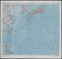
AAF cloth chart ; no. C-52, C-53, AAF cloth chart ; no. C-52, C-53., and East China Sea
Description:
"May 1945.", "N1205-E11320/2703X3740"--Verso., Includes location diagram., Relief shown by contours and spot heights., and Title on verso: East China Sea.
Publisher:
Army Map Service, U.S. Army,
Subject (Geographic):
East China Sea--Maps, Japan--Maps, and South China Sea--Maps
Subject (Name):
United States. Aeronautical Chart Service and United States. Army Air Forces
Subject (Topic):
Aeronautical charts--East China Sea, Aeronautical charts--Japan, Sea of, and Aeronautical charts--South China Sea
Found in:
Beinecke Rare Book and Manuscript Library > Japan and South China Seas / prepared at the direction of the commanding general, Army Air Forces, for the Aeronautical Chart Service by the Lake Survey Branch, Army Map Service, Detroit, Michigan, March 1945.
Creator:
Published / Created:
[1944?]
Call Number:
11hc 1944C
Image Count:
2
Resource Type:
Maps, Atlases & Globes
Alternative Title:
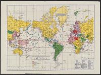
Military and naval map of World War II
Description:
Ancillary maps on verso: [1.] The far east. Scale [ca. 1:40 900 000] at equator -- [2.] Western hemisphere defense map. Scale [ca. 1:35 000 000]. and Legend and dates of war declarations.
Publisher:
Rand McNally and Company,
Subject (Topic):
World maps and World War, 1939-1945--Maps
Found in:
Beinecke Rare Book and Manuscript Library > Military map of the world.
Published / Created:
1918?]
Call Number:
38hc 1918E
Container / Volume:
BRBL_00172
Image Count:
1
Resource Type:
Maps, Atlases & Globes
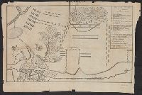
Description:
Ms. annotations in black and red ink.
Publisher:
s.n.,
Subject (Geographic):
Lorraine (France)--Military maps
Subject (Topic):
World War, 1914-1918--France--Lorraine and World War, 1914-1918--Maps
Found in:
Beinecke Rare Book and Manuscript Library > Minenwerfer-Karte, Div. "H".
Creator:
Published / Created:
1945
Call Number:
11hd 1945D
Container / Volume:
BRBL_00010ZF
Image Count:
1
Resource Type:
Maps, Atlases & Globes
Description:
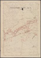
"Cleared for mailing by AC of S G-2, Eighth Army." and Shows movement of Eighth Army and Sixth Army operations.
Publisher:
67th Engineer Topo Co : and SWPA,
Subject (Geographic):
Philippines--Maps
Subject (Topic):
World War, 1939-1945--Campaigns--Philippines--Maps
Found in:
Beinecke Rare Book and Manuscript Library > Philippine campaign / reproduced by 67th Engineer Topo Co, SWPA.
Creator:
Published / Created:
[1945?]
Call Number:
11hd 1941R
Image Count:
1
Resource Type:
Maps, Atlases & Globes
Alternative Title:
World War II
Description:
"Courtesy of Carstairs white seal blended whiskey ... ", 11hc 1945., and Legend.
Publisher:
Rand McNally & Co.,
Subject (Topic):
World maps and World War, 1939-1945--Maps
Found in:
Beinecke Rare Book and Manuscript Library > Rand McNally war map.
Branch:v1.61.8 ,Deployed:2024-06-20T11:15:02-04:00