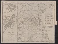
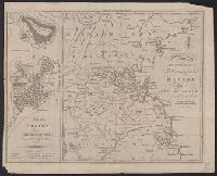
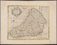
Concentric rings at one mile intervals from Huntingdon., Dedicated to the Robert Montagu, Duke of Manchester., Imperfect: edges trimmed, with loss of imprint information. Dissected and mounted on linen. In cover with label "17 Huntingdonshire.", Notes about the county; includes "Index Villaris.", Prime meridian: London., Relief shown by hachures., and Shows boundaries, roads, woods, parks and settlements.
Publisher:
[Emanuel Bowen?],
Subject (Geographic):
Huntingdonshire (England)--Early works to 1800--Maps.
Subject (Name):
Bowles, John, 1701-1779, publisher. and Hinton, John, -1781, bookseller.
Concentric rings at one mile intervals from Huntingdon., Dedicated to the Robert Montagu, Duke of Manchester., Notes about the county; includes "Index Villaris.", Prime meridian: London., Relief shown by hachures., and Shows boundaries, roads, woods, parks and set
Subject (Geographic):
Huntingdonshire (England)--Early works to 1800--Maps
Subject (Name):
Bowles, John, 1701-1779, publisher and Hinton, John, -1781, bookseller
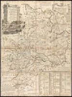
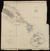
"No. 69" in lower left corner., Bar scale given in "English miles 60 to a degree.", Cross Collection no. 308., From Bowen's A complete system of geography. London : Printed for W. Innys, R. Ware ..., 1747., Hand col., Imperfect: wormholes in margins, with no loss of text., Includes table of parish acreages and ornamental cartouche., and Relief shown pictorially.
Publisher:
Printed for W. Innys, R. Ware ...,
Subject (Geographic):
Barbados--Maps--Early works to 1800
Subject (Name):
Bowen, Emanuel, d. 1767. A complete system of geography
"European Magazine" in upper right., Coordinates not present on map and are approximated., Imperfect: left portion of map and upper right portion of map wanting, with some loss of text., Relief shown pictorially., and Watermark.
Publisher:
Published April 1, 1782, by I. Fielding, Pater noster Row, J. Sewell, Cornhill, and J. Debrett, Piccadilly,
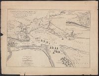
A view of the action gained by the English Sepr. 13 1759 near Quebec.
Description:
Includes inscription to William Pitt from Thos. Jefferys, Insets: Part of the upper river of St. Laurence -- A view of the action gained by the English Sepr. 13 1759 near Quebec, brought from there by an officer of distinction., and Oriented with north to upper
Publisher:
Thos. Jefferys?,
Subject (Geographic):
Saint Lawrence River Estuary (Québec)--History, Military--Maps
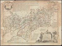
A view of the action gained by the English Sepr. 13 1759 near Quebec.
Description:
Insets: [1.] Part of the upper river of St. Laurence -- [2.] A view of the action gained by the English Sepr. 13, 1759, near Quebec, brought from thence by an officer of distinction., Oriented with north to upper right, and Relief shown by hachures and shading.
Publisher:
Published by Thos. Jefferys, Geographer to his Royal Highness the Prince of Wales, near Charing Cross,
Subject (Geographic):
Saint Lawrence River Estuary (Québec)--History, Military--Maps
Subject (Name):
Jefferys, Thomas, d. 1771 and Pitt, William, Earl of Chatham, 1708-1778, dedicatee