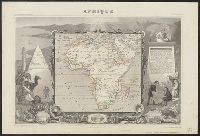
Hand col. Sheet measures 35 x 52 cm., In upper margins: Atlas universel illustré ... Ancien continent., Includes engraved illustrations in borders, statistics, descripti, Inset views: [1.] Alexandrie -- [2.] Le Caire -- [3.] Alger., and Relief shown by hachures.
Publisher:
Chez A. Combette, editeur, rue de la Parcheminerie 15,
Subject (Geographic):
Africa--Maps
Subject (Name):
Bonheur, Raimond, Combette, A, Lemercier, Alfred, printer, and Levasseur, V
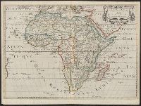
"Avec privilege du Roy.", dgvmp2008., Hand col. Sheet measures 51 x 70 cm. Ms. no. on verso: 49., Has watermarks., Includes text, ill., and Relief shown pictorially.
Publisher:
Chez I.B. Nolin, sur le Quay de l'Horloge du Palais ...,
Subject (Geographic):
Africa--Maps--Early works to 1800
Subject (Name):
Loon, H. V. (Herman van) and Nolin, Jean Baptiste, 1648-1708
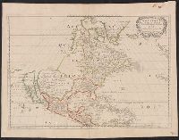
Covers area from northern South America to Greenland and includes the British Isles and the Azores., McLaughlin third state, with Lake Ontario shaded. Mounted on board. Sheet measures 47 x 61 cm. Ms. nos. on recto: 42, 28., Relief shown pictorially., and Shows C
Publisher:
Chez l'autheur, et chez Pierre Mariette, rue S. Iacques a l'Esperāce,
Subject (Geographic):
North America--Maps--Early works to 1800
Subject (Name):
Mariette, Pierre, 1603-1657 and Peyrounin, A., engraver
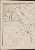
Appeared in Guillaume Sanson's Cartes générales de toutes les parties du monde., Cross collection no. 20., Differs from the 1650 Sanson map in its detail of the Gulf of California and its labeling of oceans--LVA web site., Imperfect: mutilated, with some loss of text. Mounted on linen., No. 1 of 3 maps mounted on linen., Relief shown pictorially., Shows California as an island. Includes the Southwest and Mexico., and Watermark.
Publisher:
Chez Pierre Mariette, ruë St. Jacques à l'Espera[n]ce, avec privilege de Sa Mai[es]té pour 20-äns,
Subject (Geographic):
North America--Maps--Early works to 1800
Subject (Name):
Mariette, Pierre, 1634-1716 and Sanson, Guillaume. Cartes générales de toutes les parties du monde
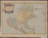
Appeared in Guillaume Sanson's Cartes générales de toutes les parties du monde., Imperfect: mutilated, with some loss of text. Mounted on linen. Sheet measures 43 x 59 cm. Cross collection no. 20. No. 1 of 3 maps mounted on linen., Mounted on cardboard. Sheet measures 46.3 x 59.8 cm. Cross collection no. 141., Relief shown pictorially., Shows California as an island. Includes the Southwest and Mexico., and Watermark.
Publisher:
Chez Pierre Mariette, ruë St. Jacques à l'Espera[n]ce, avec privilege de Sa Mai[es]té pour 20-äns,
Subject (Geographic):
North America--Maps--Early works to 1800
Subject (Name):
Mariette, Pierre, 1634-1716 and Sanson, Guillaume. Cartes générales de toutes les parties du monde
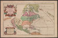
L'Amerique septentrionale divisée en ses principales parties, sçauoir les terres arcticques, le Canada ou Nouvelle France, le Mexique ou Nouvelle Espagne, le Nouveau Mexique, les isles de Terre Neuve, de Californie, et Antilles ou sont distingués les u
Description:
"Auec priuilege du Roy pour vingt ans.", "Presentée a Monseigneur le Davphin, parson tres humble, tres-obeissant, et tres fidele seruiteur, Hubert Iaillot.", Appears in Jaillot's Atlas françois., Prime meridian: Ferro., Relief shown pictorially., and Shows Calif
Publisher:
Chez H. Iaillot joignant les grands Augustins aux deux globes,