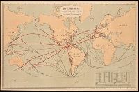
Includes "Table showing distances in miles between commercial ports of the world and distances saved by the Nicaragua Canal." and Shows "present routes" in black and "new routes via Nicaragua canal" in red.
Publisher:
Julius Bein & Co., Photo. Lith.,
Subject (Geographic):
Nicaragua Canal (Nicaragua)--Maps. and Nicaragua--Nicaragua Canal
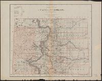
Preliminary agricultural map of Colville region, Washington Terr., Preliminary agricultural map of Yakima Region., and Soils of the Yakima and Colville regions.
Description:
Accompanied by text: Soils of the Yakima and Colville regions (1 leaf ; 61 cm.), Cover title., Preliminary agricultural map of Yakima Region -- Preliminary agricultural map of Colville region, Washington Terr., Raphael Pumpelly, director., and Relief shown by contours, spot heights, and hachures.
Publisher:
Julius Bien & Co.,
Subject (Name):
Hilgard, Eugene W. (Eugene Woldemar), 1833-1916, Julius Bien & Co, and Pumpelly, Raphael, 1837-1923
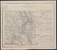
"Department of the Interior, General Land Office, J.S. Williamson, Commissioner.", "Photo lith and print by Julius Bien, 16 and 18 Park Place, N.Y.", and Relief shown by hachures.
Publisher:
J. Bien,
Subject (Geographic):
Colorado--Maps
Subject (Name):
Julius Bien & Co and United States. General Land Office
Includes population chart and index to ownership of electric railways., Inset: Map showing the lines of communication between New York, Boston and the West., and Relief shown by shading and spot heights.