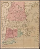
Drawn by Mr. Medcalfe & Eng. by Wm. Faden, Engraved map showing locations of bodies of water, roads, towns, forts, battles, elevations hanchured. Route of the British army shown in colo, and Removed from Atlas of Battles of the Am. Revolution, ect. London 1793.
Accompanied by the author's: A topographical description of such parts of North America as are contained in the (annexed) map of the middle British colonies, &c. in North America. vi, 46, 16 p., Includes text, list of townships, distance charts, and inset "A sketch of the remaining part of Ohio R. &c.", Prime meridian: London and Philadelphia., Relief shown pictorially., and Without accompanying text.
Publisher:
Printed & published ... for J. Almon,
Subject (Geographic):
North America--Maps--Early works to 1800 and Northeastern States--Maps--Early works to 1800.
Subject (Name):
Almon, John, 1737-1805, Evans, Lewis, 1700?-1756, and Turner, James, -1759
Accompanied by the author's: A topographical description of such parts of North America as are contained in the (annexed) map of the middle British colonies, &c. in North America. vi, 46, 16 p. and Includes text, list of townships, distance charts, and inset
Publisher:
Printed & published ... for J. Almon,
Subject (Geographic):
America, Canada--Maps--Early works to 1800, East (U.S.)--Maps--Early works to 1800, and Northeastern States--Maps--Early works to 1800.
Subject (Name):
Almon, John, 1737-1805, Evans, Lewis, 1700?-1756, and Turner, James, -1759
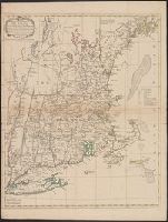
Accompanied by the author's: A topographical description of such parts of North America as are contained in the (annexed) map of the middle British colonies, &c. in North America. vi, 46, 16 p., Includes text, list of townships, distance charts, and inset "A sketch of the remaining part of Ohio R. &c.", Prime meridian: London and Philadelphia., Relief shown pictorially., and Without accompanying text.
Publisher:
Printed & published ... for J. Almon,
Subject (Geographic):
North America--Maps--Early works to 1800 and Northeastern States--Maps--Early works to 1800.
Subject (Name):
Almon, John, 1737-1805, Evans, Lewis, 1700?-1756, and Turner, James, -1759
A textual note at upper left reads "The Course of the Ohio or Alliganey River and its Branches are laid down from Surveys and Draughts made on the Spot by M.r Gist and others in the Years 1751, 2, 3 & 4". and Cartouche designed by Francis Hayman and engraved
Publisher:
Thomas Jefferys,
Subject (Geographic):
Maryland--Maps--Early works to 1800., Middle Atlantic States--Maps--Early works to 1800., and Virginia--Maps--Early works to 1800.
Subject (Name):
Byrd, William, 1674-1744., Churton, William, 1710-1767, surveyor., Dalrymple, John, -1766, surveyor., Dandridge, William, -1743., Fitzwilliam, Richard, -1744., and Fry, Joshua, approximately 1700-1754, ca