Atlas de España y sus posesiones de ultramar and Diccionario Geográfico-Estadístico-Histórico.
Description:
"El contorno por Leclercq, la topografia por Desbuissons, la letra por Bacot.", "Grabado en Madrid bajo la direccion del autor.", Hand col. Map sheet, covers, In upper left of margin: Diccionario Geográfico-Estadístico-Histórico., and Incl. 4 insets.
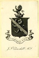
A coat of arms featuring a large lion. A diagonal band placed over the lion divides the plate in half. At the top of the crest is a second lion rising above a crown. Below on a banner reads the motto Siempre Fiel.
Subject (Name):
Churchill, J. F.
Subject (Topic):
Armorial, Armorial bookplates., Crown, Lion, Nature, Physicians, Shield, and Shields
Mexico. Dirección de Estudios Geográficos y Climatológicos
Published / Created:
[1922]
Call Number:
881 1922
Container / Volume:
BRBL_00650
Image Count:
2
Resource Type:
Maps, Atlases & Globes
Description:
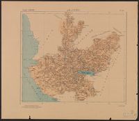
"No. 14.", Accompanied by physiographic plate covering same area, showing only relief and drainage (1 sheet : col. ; 56 cm.)., Appears in Atlas geográfico de la República Mexicana., and Relief shown by shading.
Publisher:
La Dirección,
Subject (Geographic):
Jalisco (Mexico)--Maps
Subject (Name):
Mexico. Dirección de Estudios Geográficos y Climatológicos. Atlas geográfico de la República Mexicana
Manuscript copy in Spanish of a 1793 Spanish land grant by Louisiana Governor Francisco Louis Hector Carondelet to Don Joseph Valliere, and signed by Carlos Trudeau, Royal and Private Surveyor of the Province of Louisiana. The grant contains a map showing the location of the land on the White River in the present-day states of Arkansas and Missouri, and is impressed with the seal of the State of Louisiana, certified in English, dated December 7, 1840, and signed by L. Bringier, Surveyor General of Louisiana. The land grant copy is accompanied by an English translation of the grant and copies in an unidentified hand of three letters regarding the property including that of John Wilson to W. A. Bradley, Washington City (October 17, 1841); a letter to Wilson from [Beragency?], New Orleans (undated); and to John Wilson from H. H. Williams, New Orleans (June 19, 1841).
Description:
Joseph Valliere was a Captain in the Spanish Army and served in Louisiana; he died in 1799. and Purchased from Fred A. Rosenstock on the Frederick W. & Carrie S. Beinecke Fund for Western Americana, 1975.
Subject (Name):
Bradley, W. A, Bringier, Louis, Louisiana.--Governor (1791-1797 : Carondelet), Louisiana.--Surveyor General's Office, Trudeau, Charles, Valliere, Joseph,---approximately 1799, Williams, H. H., and Wilson, John,--active 1841
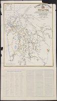
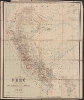
Map shows major methods of communication and transportation.
Description:
"Edwardo Higginson, Konsul för Perú, Southampton"., Map text and explanation in Spanish and Swedish., Prime meridian: Paris., and Relief shown by hachures and spot heights.
Publisher:
George Philip & Son,
Subject (Geographic):
Peru--Maps
Subject (Name):
George Philip & Son, Larrabure y Unánue, D. E, and London Geographical Institute