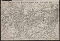
Railway and distance map accompanying Rand, McNally and Co.'s Railway Guide
Description:
Imperfect: wormholes on left edge of map, with some loss of text; lower left corner of map wanting, with some loss of text. Removed from Rand McNally and Company's railway guide (October, 1872).
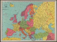
On verso: Europe in 1921, with railways. - Western fron. - Section of Maginot line fortification. - Europe air mileage distances. - Unification of Germany, 1866-1871. - Text., Shows 1914 boundarie, and Title on cover when folded: Rand McNally war map of Europe.
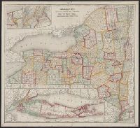
New railroad, county and township map of New York and Railroad, county and township map of New York
Description:
Insets: [Niagara River region] -- [New York metropolitan area] -- [Long Island]., Prime meridians: Greenwich and Washington., and Relief shown by hachures.
Publisher:
Rand, McNally & Co.,
Subject (Geographic):
New York (State)--Administrative and political divisions--Maps. and New York (State)--Maps.