
You Searched For
« Previous
| 1 - 10 of 15 |
Next »
Search Results

2.
- Creator:
- Hondius, Jodocus, 1594 or 1595-1629
- Published / Created:
- [1629]
- Call Number:
- 966 1730
- Container / Volume:
- BRBL_00699
- Image Count:
- 1
- Resource Type:
- Maps, Atlases & Globes
- Description:
- Cross Collection no. 350., From Jodocus Hondius's Appendix Atlantis majoris. [Amsterdam] : Per Iodocum Hondium, 1630., Imperfect: mutilated along fold at bottom, with no loss of text. Mounted on linen., Map of the Straits of Magellan, South America., Relief shown pictorially., and Title in Latin; place names in Dutch.
- Publisher:
- Judocus Hondius excudit,
- Subject (Geographic):
- Magellan, Strait of (Chile and Argentina)--Maps--Early works to 1800
- Subject (Name):
- Gryp, Dirck, engraver and Hondius, Jodocus, 1594 or 1595-1629. Appendix Atlantis majoris
- Found in:
- Beinecke Rare Book and Manuscript Library > Freti Magellanici ac novi freti vulgo le Maire exactissima delineatio / [cartographic material] / D Grÿp, sculp.
- Creator:
- Blaeu, Willem Janszoon, 1571-1638
- Published / Created:
- [1635]
- Call Number:
- 966 1625
- Container / Volume:
- BRBL_00699
- Image Count:
- 2
- Resource Type:
- Maps, Atlases & Globes
- Alternative Title:
- Afbeelding der Straet Magellanes
- Description:
- Bar scales in "Miliaria Germanica communia" and "Miliaria Gallica communia.", From Blaeu's Le theatre du monde ... Amsterdami : Apud Guiljelmum et Iohannem Blaeu, 1635., In French on verso, with caption title "Le Destroict de Magellanes, & celuy de la Maire" and signature 7L., and Relief shown pictorially.
- Publisher:
- Guiljelmus Blaeuw excudit,
- Subject (Geographic):
- Magellan, Strait of (Chile and Argentina)--Maps--Early works to 1800
- Subject (Name):
- Blaeu, Joan, 1596-1673. Theatrum orbis terrarum. French, Blaeu, Willem Janszoon, 1571-1638. Theatrum orbis terrarum. French, and Gryp, Dirck, engraver
- Found in:
- Beinecke Rare Book and Manuscript Library > Freti Magellanici ac novi freti vulgo le Maire exactissima delineatio : = Afbeelding der Straet Magellanes : so als de selve van Mr. Barent Iansz : potgeieter van Munster door en weder door bevaren en met syn Capiteyn Sebald de Waerd met groot pericul syn
- Creator:
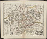
- Keere, Pieter van den, 1571-approximately 1646
- Published / Created:
- [between 1652 and 1684]
- Call Number:
- 36 1630
- Container / Volume:
- BRBL_00117
- Image Count:
- 1
- Resource Type:
- Maps, Atlases & Globes
- Description:
- Appears in Jansson's historical atlas editions from 1652-1684., Hand colored., and Relief shown pictorially.
- Publisher:
- Apud Joannem Janssonium,
- Subject (Geographic):
- Benelux countries--Historical geography--Maps--Early works to 1800., Benelux countries--Maps--Early works to 1800., Europe, Central--Historical geography--Maps--Early works to 1800., Europe, Central--Maps--Early works to 1800., Europe, Eastern--Historical geography--Maps--Early works to 1800., Europe, Eastern--Maps--Early works to 1800., Germany--Historical geography--Maps--Early works to 1800., and Germany--Maps--Early works to 1800.
- Subject (Name):
- Jansson, Jan, 1588-1664
- Subject (Topic):
- Ethnology--Europe--Maps--Early works to 1800. and Germanic peoples--Maps--Early works to 1800.
- Found in:
- Beinecke Rare Book and Manuscript Library > Germaniae veteris nova descriptio / Petrus Kaerius celavit.
- Creator:
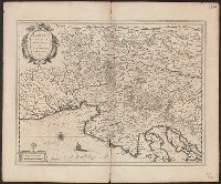
- Mercator, Gerhard, 1512-1594
- Published / Created:
- [1635]
- Call Number:
- 46 1630
- Container / Volume:
- BRBL_00259
- Image Count:
- 2
- Resource Type:
- Maps, Atlases & Globes
- Alternative Title:
- Karstia, Carniola, Histria et Windorvm marchia
- Description:
- Bar scale given in "milliaria Italica communia"., From Blaeu's Theatrum orbis terrarum, 1635., In Latin on verso; with caption title "Descriptio Karstiae, Carniolae, Windorum marchiae, comitatus Ciliae fori Iulii, necnon Istriae" and signature K., and Relief sho
- Publisher:
- Guiljelm. Blaeu excudit,
- Subject (Geographic):
- Carniola (Slovenia)--Maps--Early works to 1800 and Croatia--Maps--Early works to 1800
- Subject (Name):
- Blaeu, Joan, 1596-1673. Theatrum orbis terrarum and Blaeu, Willem Janszoon, 1571-1638. Theatrum orbis terrarum
- Found in:
- Beinecke Rare Book and Manuscript Library > Karstia, Carniola, Histria et Windorum marchia / Ger. Mercatore auctore.
- Published / Created:
- [1635?]
- Call Number:
- 335 N15 1635
- Container / Volume:
- BRBL_00087
- Image Count:
- 2
- Resource Type:
- Maps, Atlases & Globes
- Alternative Title:
- Namvrcvm comitatvs
- Description:
- Preliminary record.
- Publisher:
- apud Guiljelmum et Johannem Blaeu,
- Subject (Geographic):
- Namur (Belgium)--Maps--Early works to 1800
- Found in:
- Beinecke Rare Book and Manuscript Library > Namurcum comitatus / auctore Iohann Surhonio.
- Creator:
- Blaeu, Willem Janszoon, 1571-1638
- Published / Created:
- [1630]
- Call Number:
- 783 1630
- Container / Volume:
- BRBL_00507
- Image Count:
- 1
- Resource Type:
- Maps, Atlases & Globes
- Alternative Title:
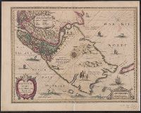
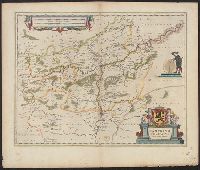
- Nova Virginiae tabvla
- Description:
- From Willem Janszoon Blaeu's Atlantis appendix ... Amsterdami : Apud Guiljelmum Blaeuw, 1630., Oriented west., Relief shown pictorially., Sheet measures 45.2 x 54.8 cm., and Upper left: Portait of Powhatan with subtitle: Status regis Powhatan quando pr
- Publisher:
- Ex Officina Guiljelmi Blaeuw,
- Subject (Geographic):
- Chesapeake Bay Region (Md. and Va.)--Maps--Early works to 1800, Maryland--Maps--Early works to 1800, and Virginia--Maps--Early works to 1800
- Subject (Name):
- Blaeu, Willem Janszoon, 1571-1638. Atlantis appendix, Gryp, Dirck, engraver, Powhatan, ca. 1550-1618, and Smith, John, 1580-1631
- Subject (Topic):
- Powhatan Indians--Pictorial works--Early works to 1800
- Found in:
- Beinecke Rare Book and Manuscript Library > Nova Virginiae tabula / DGrijp sculpt.
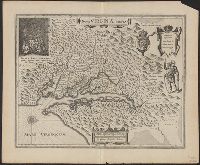
- Creator:
- Blaeu, Willem Janszoon, 1571-1638
- Published / Created:
- [1635]
- Call Number:
- 783 1630
- Container / Volume:
- BRBL_00691
- Image Count:
- 2
- Resource Type:
- Maps, Atlases & Globes
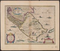
- Alternative Title:
- Nova Virginiae tabvla
- Description:
- From Willem Janszoon and Joan Blaeu's Theatrum orbis terrarum ... Amsterdami : Apud Guiljelmum et Iohannem Blaeu, 1635., Hand col. Sheet measures 45.8 x 59.7 cm. Cross Collection no. 210., Latin on verso, with running title "Virginia" and signature "D"., Oriented west., Relief shown pictorially., Upper left: Portait of Powhatan with subtitle: "Status regis Powhatan quando prefectus Smith Captivus illi daretur"., and Upper right: Key to symbols.
- Publisher:
- Ex Officina Guiljelmi Blaeuw,
- Subject (Geographic):
- Chesapeake Bay Region (Md. and Va.)--Maps--Early works to 1800 and Virginia--Maps--Early works to 1800
- Subject (Name):
- Blaeu, Joan, 1596-1673. Theatrum orbis terrarum, Blaeu, Willem Janszoon, 1571-1638. Theatrum orbis terrarum, Gryp, Dirck, engraver, Powhatan, ca. 1550-1618, and Smith, John, 1580-1631
- Subject (Topic):
- Powhatan Indians--Pictorial works--Early works to 1800
- Found in:
- Beinecke Rare Book and Manuscript Library > Nova Virginiae tabula / DGrijp sculpt.
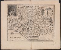
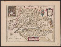
- Creator:
- Blaeu, Willem Janszoon, 1571-1638
- Published / Created:
- [1635]
- Call Number:
- 783 1630A
- Container / Volume:
- BRBL_00691
- Image Count:
- 2
- Resource Type:
- Maps, Atlases & Globes
- Alternative Title:
- Nova Virginiae tabvla
- Description:
- From Blaeu's Novus atlas ... Amsterdami : Apud Guiljelmum Blaeuw, 1635., Oriented west., Relief shown pictorially., Upper left: Portait of Powhatan with subtitle: Status regis Powhatan quando prefectus Smith Captivus illi daretur., Upper right: Key to symbols., and Verso in German, with running title "Landschafft Virginia" and signature "B".
- Publisher:
- Ex Officina Guiljelmi Blaeuw,
- Subject (Geographic):
- Virginia--Maps--Early works to 1800
- Subject (Name):
- Blaeu, Willem Janszoon, 1571-1638. Theatrum orbis terrarum. German, Gryp, Dirck, engraver, Powhatan, ca. 1550-1618, and Smith, John, 1580-1631
- Subject (Topic):
- Powhatan Indians--Pictorial works--Early works to 1800
- Found in:
- Beinecke Rare Book and Manuscript Library > Nova Virginiae tabula / DGrijp sculpt.

- Published / Created:
- [1639]
- Call Number:
- 19 1639
- Container / Volume:
- BRBL_00013
- Image Count:
- 2
- Resource Type:
- Maps, Atlases & Globes
- Description:
- Preliminary record. and Text on verso. Cf. Phillips, v. 1 no. 452.
- Publisher:
- H. Hondius,
- Subject (Geographic):
- Antarctica--Maps--Early works to 1800
- Found in:
- Beinecke Rare Book and Manuscript Library > Polus Antarcticus.