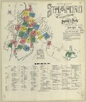
Sanborn fire insurance maps are a rich source of historic data on the urban built environment of North America during the 19th and early 20th centuries. The atlases were created for the purpose of underwriting fire insurance policies, which depended upon accurate and frequently-updated information about construction materials, municipal and transportation infrastructure, industrial and commercial landuse and more. The Yale University Library Map Department scanned its holdings of Sanborn fire insurance maps (consisting primarily of Connecticut towns) in order to make the maps more accessible.
Alternative Title:
Nov. 1901, Stamford, Conn. and Stamford, Fairfield Co., Connecticut
Description:
"26 sheets. (5099).", Accompanied by new sheets 48, 49, 58 (dated Jan. 1918) and 55 (dated Sept. 1916), and additional sheets 56, 57, 58 (dated Sept. 1916), 59 (dated Jan. 1918) and 65 (dated Dec. 1921)., Contains information on population, prevailing winds, water facilities and fire department., Includes index of streets and specials., Partial cadastral map., and SMLMAPL 766 St22 1901: Sheets disbound. "Triplicate" stamp on all sheets. Library of Congress copyright stamp on title sheet.
Subject (Geographic):
Stamford (Conn.)--Maps
Subject (Name):
Library of Congress Stamp
Subject (Topic):
Fire risk assessment--Connecticut--Stamford--Maps and Real property--Connecticut--Stamford--Maps
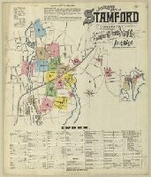
Sanborn fire insurance maps are a rich source of historic data on the urban built environment of North America during the 19th and early 20th centuries. The atlases were created for the purpose of underwriting fire insurance policies, which depended upon accurate and frequently-updated information about construction materials, municipal and transportation infrastructure, industrial and commercial landuse and more. The Yale University Library Map Department scanned its holdings of Sanborn fire insurance maps (consisting primarily of Connecticut towns) in order to make the maps more accessible.
Alternative Title:
Aug. 1896, Stamford, Conn. and Stamford, Fairfield County, Connecticut
Description:
"17 sheets. (669).", Contains information on population, prevailing winds, water facilities and fire department., Includes index of streets and specials., Partial cadastral map., and SMLMAPL 766 St22 1896: Sheets disbound. "Triplicate" stamp on all sheets. Library of Congress copyright and Map Division stamps on title sheet.
Subject (Geographic):
Stamford (Conn.)--Maps
Subject (Name):
Library of Congress Stamp and Library of Congress. Map Division Stamp
Subject (Topic):
Fire risk assessment--Connecticut--Stamford--Maps and Real property--Connecticut--Stamford--Maps
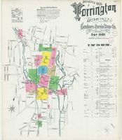
Sanborn fire insurance maps are a rich source of historic data on the urban built environment of North America during the 19th and early 20th centuries. The atlases were created for the purpose of underwriting fire insurance policies, which depended upon accurate and frequently-updated information about construction materials, municipal and transportation infrastructure, industrial and commercial landuse and more. The Yale University Library Map Department scanned its holdings of Sanborn fire insurance maps (consisting primarily of Connecticut towns) in order to make the maps more accessible.
Alternative Title:
Oct. 1901 Torrington, Conn. and Torrington, Litchfield Co., Connecticut
Description:
"13 sheets (5046).", Contains information on population, prevailing winds, water facilities and fire department., Includes index of streets and specials., Partial cadastral map., and SMLMAPL 766 T63 1901: Sheets disbound. "Triplicate" stamp on sheet. Library of Congress copyright stamp on title sheet.
Subject (Geographic):
Torrington (Conn.)--Maps
Subject (Name):
Library of Congress Stamp
Subject (Topic):
Fire risk assessment--Connecticut--Torrington--Maps and Real property--Connecticut--Torrington--Maps
Sanborn fire insurance maps are a rich source of historic data on the urban built environment of North America during the 19th and early 20th centuries. The atlases were created for the purpose of underwriting fire insurance policies, which depended upon accurate and frequently-updated information about construction materials, municipal and transportation infrastructure, industrial and commercial landuse and more. The Yale University Library Map Department scanned its holdings of Sanborn fire insurance maps (consisting primarily of Connecticut towns) in order to make the maps more accessible.
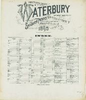
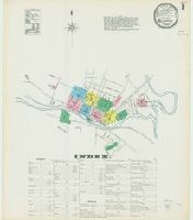
Alternative Title:
Waterbury, Conn., Waterbury, New Haven Co., Connecticut, and Waterbury, New Haven County, Connecticut
Description:
"Waterbury, Conn. (4826)", Accompanied by new sheet 71 (dated May 1918) and additional sheets 78 and 79 (dated May 1918)., Contains information on population, water facilities, and fire department., Includes index of streets and specials and key map., Partial cadastral map., SMLMAPL 766 W29 1901: Sheets disbound. "Triplicate" stamp on sheets. Library of Congress copyright stamp on title sheet., and The unnumbered leaves are the title/index sheet and the map index sheet.
Subject (Geographic):
Waterbury (Conn.)--Maps
Subject (Name):
Library of Congress Stamp
Subject (Topic):
Fire risk assessment--Connecticut--Waterbury--Maps and Real property--Connecticut--Waterbury--Maps
Sanborn fire insurance maps are a rich source of historic data on the urban built environment of North America during the 19th and early 20th centuries. The atlases were created for the purpose of underwriting fire insurance policies, which depended upon accurate and frequently-updated information about construction materials, municipal and transportation infrastructure, industrial and commercial landuse and more. The Yale University Library Map Department scanned its holdings of Sanborn fire insurance maps (consisting primarily of Connecticut towns) in order to make the maps more accessible.
Alternative Title:
April 1895, Waterbury, Conn., Waterbury, Conn., and Waterbury, New Haven County, Connecticut
Description:
"34 sheets (7858).", Contains information on population, water facilities, and fire department., Includes index of streets and specials., Partial cadastral map., SMLMAPL 766 W29 1895: Sheets disbound. "Triplicate" stamp on sheets. Library of Congress copyright stamp on title sheet., and The unnumbered leaf is the title and index sheet; sheets 11 and 15 are duplicated as "skeleton" sheets, numbered 11S and 15S.
Subject (Geographic):
Waterbury (Conn.)--Maps
Subject (Name):
Library of Congress Stamp
Subject (Topic):
Fire risk assessment--Connecticut--Waterbury--Maps and Real property--Connecticut--Waterbury--Maps
Sanborn fire insurance maps are a rich source of historic data on the urban built environment of North America during the 19th and early 20th centuries. The atlases were created for the purpose of underwriting fire insurance policies, which depended upon accurate and frequently-updated information about construction materials, municipal and transportation infrastructure, industrial and commercial landuse and more. The Yale University Library Map Department scanned its holdings of Sanborn fire insurance maps (consisting primarily of Connecticut towns) in order to make the maps more accessible.
Alternative Title:
June 1897, Willimantic Conn., Willimantic, Windham Co., Conn., and Willimantic, Windham County
Description:
"11 sheets (1301).", Contains information on population, prevailing winds, water facilities and fire department., Includes index of streets and specials., Partial cadastral map., and SMLMAPL 766 W677 1897: Sheets disbound. "Triplicate" stamp on sheets. Manuscript Library of Congress copyright number and date "418472̲ July 20th, 1897" on title sheet.
Subject (Geographic):
Willimantic (Conn.)--Maps
Subject (Name):
Library of Congress Stamp
Subject (Topic):
Fire risk assessment--Connecticut--Willimantic--Maps and Real property--Connecticut--Willimantic--Maps
Sanborn fire insurance maps are a rich source of historic data on the urban built environment of North America during the 19th and early 20th centuries. The atlases were created for the purpose of underwriting fire insurance policies, which depended upon accurate and frequently-updated information about construction materials, municipal and transportation infrastructure, industrial and commercial landuse and more. The Yale University Library Map Department scanned its holdings of Sanborn fire insurance maps (consisting primarily of Connecticut towns) in order to make the maps more accessible.
Alternative Title:
June 1892, Willimantic Conn., Willimantic, Windham Co., Connecticut, and Willimantic, Windham County
Description:
"10 sheets (5257).", Contains information on population, prevailing winds, water facilities and fire department., Includes index of streets and specials., Partial cadastral map., and SMLMAPL 766 W677 1892: Sheets disbound. "Triplicate" stamp on sheets. Library of Congress copyright stamp on title sheet.
Subject (Geographic):
Willimantic (Conn.)--Maps
Subject (Name):
Library of Congress Stamp
Subject (Topic):
Fire risk assessment--Connecticut--Willimantic--Maps and Real property--Connecticut--Willimantic--Maps
Sanborn fire insurance maps are a rich source of historic data on the urban built environment of North America during the 19th and early 20th centuries. The atlases were created for the purpose of underwriting fire insurance policies, which depended upon accurate and frequently-updated information about construction materials, municipal and transportation infrastructure, industrial and commercial landuse and more. The Yale University Library Map Department scanned its holdings of Sanborn fire insurance maps (consisting primarily of Connecticut towns) in order to make the maps more accessible.
Alternative Title:
Dec. 1901, Jewett City, Conn.
Description:
"5 sheets.", Contains information on population, prevailing winds, water facilities and fire department., Includes index of streets and specials., Partial cadastral map., and SMLMAPL 766 J55 1901: Sheets disbound. "Triplicate" stamp on all sheets. Library of Congress copyright stamp on title sheet.
Subject (Geographic):
Jewett City (Conn.)--Maps
Subject (Name):
Library of Congress Stamp
Subject (Topic):
Fire risk assessment--Connecticut--Jewett City--Maps and Real property--Connecticut--Jewett City--Maps