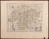
Keere, Pieter van den, 1571-approximately 1646, cartographer.
Published / Created:
[between 1652 and 1684]
Call Number:
BrSides Double Folio 2019 103
Image Count:
1
Resource Type:
Maps, Atlases & Globes
Description:
Appears in Jansson's historical atlas editions from 1652-1684., Manuscript number in upper left corner: 13., and Relief shown pictorially.
Publisher:
Apud Joannem Janssonium,
Subject (Geographic):
Benelux countries--Historical geography--Maps--Early works to 1800., Benelux countries--Maps--Early works to 1800., Europe, Central--Historical geography--Maps--Early works to 1800., and Europe, Central--Maps--Early works to 1
Subject (Name):
Jansson, Jan, 1588-1664, publisher.
Subject (Topic):
Ethnology--Europe--Maps--Early works to 1800. and Germanic peoples--Maps--Early works to 1800.
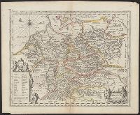
Appears in Jansson's historical atlas editions from 1652-1684., Hand colored., and Relief shown pictorially.
Publisher:
Apud Joannem Janssonium,
Subject (Geographic):
Benelux countries--Historical geography--Maps--Early works to 1800., Benelux countries--Maps--Early works to 1800., Europe, Central--Historical geography--Maps--Early works to 1800., Europe, Central--Maps--Early works to 1800., Europe, Eastern--Historical geography--Maps--Early works to 1800., Europe, Eastern--Maps--Early works to 1800., Germany--Historical geography--Maps--Early works to 1800., and Germany--Maps--Early works to 1800.
Subject (Name):
Jansson, Jan, 1588-1664
Subject (Topic):
Ethnology--Europe--Maps--Early works to 1800. and Germanic peoples--Maps--Early works to 1800.