Skip to search
Skip to main content
Skip to first result
Search
You Searched For
Format
cartographic
Genre
Illustrations
New Search
Search Results
Published / Created:
1846
Call Number:
1976 Folio 93
Collection Title:
Mitchell’s universal atlas
Image Count:
1
Resource Type:
Maps, Atlases & Globes
Subject (Geographic):
Maine
Collection Created:
Philadelphia, S.A. Mitchell, 1847, c1844
Found in:
Beinecke Rare Book and Manuscript Library > A new map of Maine
Published / Created:
1833
Call Number:
1976 Folio 98
Collection Title:
A new universal atlas, containing maps of the various empires, kingdoms, states and republics of
Image Count:
1
Resource Type:
Maps, Atlases & Globes
Subject (Geographic):
Maine
Collection Created:
Philadelphia, Published by the author, 1836
Found in:
Beinecke Rare Book and Manuscript Library > A new map of Maine
Published / Created:
1850
Call Number:
1976 Folio 96
Collection Title:
A new universal atlas containing maps of the various empires, kingdoms, states and republics of the
Image Count:
1
Resource Type:
Maps, Atlases & Globes
Publisher:
Thomas, Cowperthwait & Co
Subject (Geographic):
Maine
Collection Created:
Philadelphia, Cowperthwait, DeSilver & Butler, 1854, c1850
Found in:
Beinecke Rare Book and Manuscript Library > A new map of Maine
Call Number:
1976 Folio 94
Collection Title:
A new universal atlas containing maps of the various empires, kingdoms, states and republics of the
Image Count:
1
Resource Type:
Maps, Atlases & Globes
Subject (Geographic):
Maine
Collection Created:
Philadelphia, S.A. Mitchell, 1849
Found in:
Beinecke Rare Book and Manuscript Library > A new map of Maine
Creator:
Published / Created:
[1732]
Call Number:
E1015 M66 1732
Collection Title:
Atlas minor: or a set of sixty-two new and correct maps, of all parts of the world. All composed
Image Count:
1
Description:
Autograph of Gravely. Autograph of Baldock. Autograph of Aston. Autograph of W. Alington.
Subject (Geographic):
America--Maps--Early works to 1800
Subject (Topic):
Atlases--Early works to 1800
Collection Created:
London :
Found in:
Beinecke Rare Book and Manuscript Library > A new map of the whole world with the trade winds according to ye latest and most exact observations by H. Moll geographer.
Creator:
Published / Created:
[1732]
Call Number:
E1015 M66 1732
Collection Title:
Atlas minor: or a set of sixty-two new and correct maps, of all parts of the world. All composed
Image Count:
1
Description:
Autograph of Gravely. Autograph of Baldock. Autograph of Aston. Autograph of W. Alington.
Subject (Geographic):
America--Maps--Early works to 1800
Subject (Topic):
Atlases--Early works to 1800
Collection Created:
London :
Found in:
Beinecke Rare Book and Manuscript Library > A new map of ye north parts of America claimed by France under ye names of Louisiana. Mississipi, Canada & New France, with the adjoyning territories of England & Spain. By H. Moll geographer.
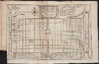
Call Number:
CF352 I54 1793
Collection Title:
A topographical description of the Western territory of North America; containing a succinct
Image Count:
1
Description:
Engrav'd for S. Campbell's Edition of Imlay's Description of Kentucky., Facing p. 111., and Teaching resource: Professor John Mack Faragher, History 141: The American West.
Subject (Geographic):
Genesee River Valley (Pa. and N.Y.) --Early works to 1800, Mississippi River Valley --Description and travel --Early works to 1800, Mississippi River Valley --History --To 1803, and Ohio River Valley --Description and travel -
Subject (Name):
Filson, John, ca. 1747-1788 Discovery, settlement, and present state of Kentucky, Toulmin, Harry, 1766-1823 Thoughts on emigration, and United States. Dept. of State
Subject (Topic):
Public lands --United States --Early works to 1800
Collection Created:
New-York, Printed by Samuel Campbell, No. 37, Hanover Square, M,DCC,XCIII
Found in:
Beinecke Rare Book and Manuscript Library > A plan of the rapids of the Ohio
Call Number:
CF2041 +L54
Collection Title:
A true & exact history of the island of Barbados. Illustrated with a mapp of the island, as also
Image Count:
1
Resource Type:
Maps, Atlases & Globes
Description:
Verso blank.
Subject (Geographic):
Barbados --Description and travel and Barbados --Maps --Early works to 1800
Collection Created:
London, Printed for H. Moseley, 1657
Found in:
Beinecke Rare Book and Manuscript Library > A topographicall description and admeasurement of the yland of Barbados in the West Indyaes with the m.rs names of the seuerall plantacons
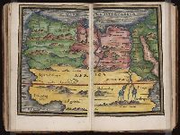
Published / Created:
[1542]
Call Number:
Taylor 86
Collection Title:
Rvdimenta cosmographica
Image Count:
1
Subject (Geographic):
Africa, Arab countries, and Middle East
Subject (Topic):
Cosmography, Early maps, and Geography, Medieval
Collection Created:
Impressvm in inclyta Transylvaniae Corona 1542
Found in:
Beinecke Rare Book and Manuscript Library > Africa
Call Number:
Ck3 35p
Collection Title:
Missive van William Penn ... : Geschreven aan de commissarissen van de Vrye Societeyt der
Image Count:
1
Description:
Facing p. 22.
Subject (Geographic):
Pennsylvania --Description and travel and Philadelphia (Pa.) --Description and travel
Subject (Name):
Holme, Thomas, d. 1695 and Paschall, Thomas, 1634-1718. Abstract of a letter. Dutch
Subject (Topic):
Indians --Pennsylvania
Collection Created:
Amsterdam : J. Claus, 1684
Found in:
Beinecke Rare Book and Manuscript Library > Afteykeninge van de Stadt Philadelphia in de Provinstie van Penn-sylvania in Americae na de Copie tot London. en intneder duyts laeten Snyden door Jacob Claus
Branch:v1.61.6 ,Deployed:2024-06-12T09:55:33-04:00