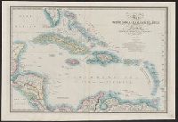
Date beneath publisher statement: March 1st 1827., Includes notes., Relief shown by hachures., Some sheets: Published by Jas. Wyld (successor to W. Faden, and Stevens and Tree describe the various issues of this map in Tooley's Mapping of America, p. 91., no. 63.
Insets: City of Washington and District of Columbia. Scale ca. 1:190,000. 13 x 14 cm. Country round Washington. Scale ca. 1:1,020,000. 18 x 24 cm.-Pensacola bay and its fortifications. Scale ca. 1:155,000. 12 x 14 cm.-Charleston and the harbour. Scale ca.
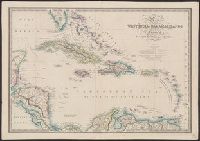
Publisher:
James Wyld
Subject (Geographic):
United States--History--Civil War, 1861-1865--Maps
Insets: Plan of the entrance to Port Manoukao -- Plan of Victoria Bay of Islands New Zealand -- Port Nicholson -- Plan of Dusky Bay -- Plan of Southern Port, Stewarts Island -- -Oyerri or Pelorus River -- Plan of the bar and part of the Hokianga River . and Plan of Port Nicholson and Oyerri by permission of the New Zealand Land Company.
Publisher:
James Wyld, geographer to the Queen, Charing Cross East,
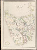
Inset: Kings Island., Map of Tasmania showing counties, railways and tramways with notes on the topography. Relief shown pictorially and by hachures and spot heights., Plate "28.", and Stamp on verso: Karpinski-von Wieser Map Collection.
Publisher:
James Wyld, Geographer to the Queen, 457, West Strand, Charing Cross East,
"27" in top right-hand corner., Map showing N.S.W. and Victoria divided into counties with notes on the topography. Gold deposits are marked. Relief shown by hachures and spot heights., and Stamp on verso: Karpinski-von Wieser Map Collection.
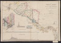
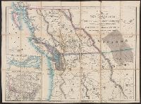
Cut and mounted on linen; "Wyld's new maps" advertisement on verso., Forts; boundaries; Indians; proposed railway; gold; coal., and Insets: Strait of San Juan de Fuca. -- on an enlarged scale. -- 7.4 x 8 cm.; British possessions in North America. -- scale [1:34
Publisher:
James Wyld,
Subject (Geographic):
British Columbia--Maps and Canada--Boundaries--United States--Maps
Subject (Topic):
Coal mines and mining--North America, Western--Maps, Gold mines and mining--British Columbia--Maps, and Indians--North America, Western--Maps