Keere, Pieter van den, 1571-approximately 1646, cartographer.
Published / Created:
[between 1652 and 1684]
Call Number:
BrSides Double Folio 2019 103
Image Count:
1
Resource Type:
Maps, Atlases & Globes
Description:
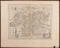
Appears in Jansson's historical atlas editions from 1652-1684., Manuscript number in upper left corner: 13., and Relief shown pictorially.
Publisher:
Apud Joannem Janssonium,
Subject (Geographic):
Benelux countries--Historical geography--Maps--Early works to 1800., Benelux countries--Maps--Early works to 1800., Europe, Central--Historical geography--Maps--Early works to 1800., and Europe, Central--Maps--Early works to 1
Subject (Name):
Jansson, Jan, 1588-1664, publisher.
Subject (Topic):
Ethnology--Europe--Maps--Early works to 1800. and Germanic peoples--Maps--Early works to 1800.
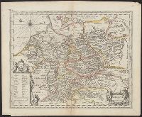
Appears in Jansson's historical atlas editions from 1652-1684., Hand colored., and Relief shown pictorially.
Publisher:
Apud Joannem Janssonium,
Subject (Geographic):
Benelux countries--Historical geography--Maps--Early works to 1800., Benelux countries--Maps--Early works to 1800., Europe, Central--Historical geography--Maps--Early works to 1800., Europe, Central--Maps--Early works to 1800., Europe, Eastern--Historical geography--Maps--Early works to 1800., Europe, Eastern--Maps--Early works to 1800., Germany--Historical geography--Maps--Early works to 1800., and Germany--Maps--Early works to 1800.
Subject (Name):
Jansson, Jan, 1588-1664
Subject (Topic):
Ethnology--Europe--Maps--Early works to 1800. and Germanic peoples--Maps--Early works to 1800.
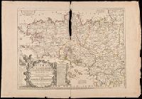
Hand colored. Stamp: Karpinski-von Wieser Map Collection. and Includes notes, explanation of scales and an "Avertissement".
Publisher:
Chez J.B. Nolin, sur le Quay de l'Horloge du Palais a l'Enseigne de la Place des Victoires, Vers le Pont Neuf, Avec Privilege du Roy,
Subject (Geographic):
Brittany (France)--Administrative and political divisions--Maps--Early works to 1800., Brittany (France)--Maps--Early works to 1800., and France--Brittany
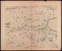
Tribus Ruben, et Gad et partes orientales tribuum Benjamin, Ephraim, et dimidiae Manasse intra Jordanem
Description:
Appears in Jansson's historical atlas editions from 1652-1684 and in his Accuratissima orbis antiqui delineatio. From 1653 on, this work is known under the name of Hornius, who wrote the text and compiled all the maps for the atlases--(Koeman-Krogt. 1:601-1:607)., Coordinates not present on map and are approximated., Includes many biblical scenes and notes., Manuscript number in upper left corner: 47. No. 1 of 6 maps housed together., Map indexed with grid lines and alphabet letters J-O at top of map under title., Map of the Hebrew tribes of Reuben and Gad, with the eastern parts of the tribes of Benjamin, Ephraim, and half of Manasseh beyond the Jordan River., Oriented with north to the left., Relief shown pictorially., and The first map drawn of a series of six sheets that form an enlarged adaptation of Andrichom's "Sitius Terrae Promissionis". This map is the sheet positioned at top, center.
Publisher:
[Jan Jansson],
Subject (Geographic):
Middle East--Palestine. and Palestine--History--To 70 A.D.--Maps--Early works to 1800.