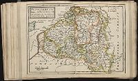
Twenty four new and accurate maps of the several parts of Europe ... : all (except the last) new
Image Count:
1
Alternative Title:
Flanders, or the Spanish Netherlands; with the bishopricks of Cambray and Liege
Description:
In pencil on verso: 14.
Subject (Geographic):
Flanders (Belgium) --Maps --Early works to 1800
Subject (Name):
Barker, B. (Benjamin), d. 1764, bookseller, Clements, Henry, d. 1719, bookseller, King, Charles, d. 1735, bookseller, Nicholson, John, d. ca. 1717, bookseller, Parker, Richard, fl. 1692-1725, bookseller, and Tooke, Benjamin, d. 1716, bookseller
Subject (Topic):
Atlases --Early works to 1800
Collection Created:
[London] : Sold by J. Nicholson at the King’s-Arms in Little Britain, Benj. Barker and Charles King ..., Benj. Tooke ..., Hen. Clements ..., R. Parker and Ralph Smith under the Royal-Exchange ..., [1715?]
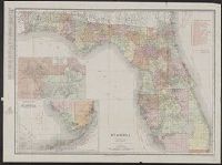
Depths shown by soundings and bathymetric isolines., Includes section along the Florida East Coast Railway from Jacksonville to Key West., and Text on verso.
Publisher:
Matthews-Northrup Works,
Subject (Geographic):
Florida--Maps
Subject (Name):
Florida East Coast Railway and Matthews-Northrup Works
Rand, McNally & Co.'s New business atlas map of Florida
Description:
Includes table for identifying marked Florida railroads., Insets: Map showing part of Lake, Orange & Volusia Counties. [Scale ca. 1:321,870] -- Southern portion of Florida. [Scale ca. 1:1,203,840]., Prime meridian: Greenwich., and Relief shown by hachures.
Covers area bounded by 26th Ave. N. and 19th Ave. N.; 22d St. and 15th St., Library's copy annotated in ink and pencil, indicating "Babbitts out lot[s] F, G, H.", and Shows subdivided city blocks.
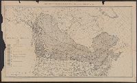
Date below scale: 1912., In lower margin: From the Proceedings of the Society of American Foresters, vol. 7, no. 2., and In upper margin: Supplement to the Paper Trade Journal, vol. LVI, no. 8, February 20, 1913 ....
Publisher:
Vance Pub. Corp.?,
Subject (Name):
Society of American Foresters. Proceedings of the Society of American Foresters
Subject (Topic):
Forests and forestry--Canada--Maps, Landforms--Canada--Maps, and Prairies--Canada--Maps
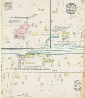
Sanborn fire insurance maps are a rich source of historic data on the urban built environment of North America during the 19th and early 20th centuries. The atlases were created for the purpose of underwriting fire insurance policies, which depended upon accurate and frequently-updated information about construction materials, municipal and transportation infrastructure, industrial and commercial landuse and more. The Yale University Library Map Department scanned its holdings of Sanborn fire insurance maps (consisting primarily of Connecticut towns) in order to make the maps more accessible.
Alternative Title:
June 1884, Forestville, Conn.
Description:
"2 sheets.", Contains information on population, prevailing winds, water facilities and fire department., Partial cadastral map., and SMLMAPL 766 F76 1884: Sheets disbound. "Triplicate" stamp on both sheets. Library of Congress copyright stamp on title sheet.
Subject (Geographic):
Forestville (Conn.)--Maps
Subject (Name):
Library of Congress Stamp
Subject (Topic):
Fire risk assessment--Connecticut--Forestville--Maps and Real property--Connecticut--Forestville--Maps