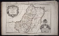
Uytenbogaart, J. W. H. (Johannes Wilhelmus Huybert) Wit, Frederik de., creator
Published / Created:
[1680?]
Call Number:
1973 Folio 10
Image Count:
1
Resource Type:
Maps, Atlases & Globes
Description:
Appears in the Wit's Atlas from 1680., Dedication: Amplissimo Doctissimoque Viro Domino Do. Joanni Uytenbogaert Jcto. nomine Illustrium et praepotent. DD. ordinum Hollandiae et Westvrisiae Aerary Publici Amstelodamensis Tribuno., Includes color illustrated views of Messina, Catania, and Trapano, and ancillary maps of Milazzo and Palermo., No. 21 of 69 maps bound together in composite atlas., Oriented with north toward the upper left., Relief shown pictorially., Scale indeterminable., and Urbibus praecipuis exornatum et novissime editum per F. de Wit.
Publisher:
Gedruckt tot Amsterdam by Frederik de Wit inde Kalverstraet by den Dam inde Witte Paskaert
Italy divided according as its severall principalities extend, which are the territories of the Church, of the Catholick king, which contain the kingdomes of Naples, Sicily, Sardinia, and the Dukedome of Millain ... described by Sanson, corrected and amended by Will. Berry
Description:
Bar scales given in Italian miles, common leagues of Germany, great German leagues, common leagues of France, great French leagues, and common leagues of Spain., Dedicated To the most serene and most sacred majesty of Charles II ... by William Berry., No. 16 of 69 maps bound together in composite atlas., Relief shown pictorially., and Scale [ca. 1:2 300 000].
Publisher:
Sold by William Berry at the signe of the Globe between Charing-Cross and White Hall
Bar scales given in Stadia, mille Passus, milliaria unius horae, leucae Gallicae, and Dietce., Ferro meridian., No. 55 of 69 maps bound together in composite atlas., Relief shown pictorially., and Scale [ca 1:650 000].
Bar scales given in mille pas geometriques, ou milles d'Italie, lieues communes de France, lieues d'une heure de Chemin, lieues communes d'Allemagne, and lieues communes de Suisse., Includes 33 coats of arms., No. 15 of 69 maps bound together in composite atlas., Relief shown pictorially., and Scale [ca. 1:585 000].
Publisher:
Chez H. Iaillot
Subject (Geographic):
Switzerland --Administrative and political divisions --Maps --Early works to 1800 and Switzerland --Maps --Early works to 1800
Cercle de Franconie, ou sont les eveches De Wurtzburg, de Bamberg, et d'Aichstet, les estats du grand Maistre des Chevaliers Teutons, les Marquisats de Cullembach, et d'Ohnspach, les Comtes d'Henneberg, d'Holach, de Reineck, de Wertheim, d'erpach, de Schwartzenberg, et de Castel, les Baronies de Limpurg, et de Sensheim, et les villes imperiales de Nurenberg, de Rotenburg, de Schweinfurt, Windsheim, et de Weissenburg
Description:
Bar scales in Italian miles, common leagues of Germany, great leagues of Germany, common leagues of France, great leagues of France, and leagues of one hours traveling., Dresse sur les Memoires les plus Nouveaux par le Sr. Sanson., Ferro meridian., No. 30 of 69 maps bound together in composite atlas., Relief shown pictorially., and Scale [ca. 1:510 000].
No. 13 of 69 maps bound together in composite atlas., Oriented with north towards upper left., Relief shown pictorially., Scale not given., and Title in Latin; place names in French.