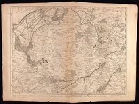
Crépy, Etienne Louis, printer Fricx, Eugène-Henri, d. 1733 Fricx, Eugène-Henri, d. 1733. Cartes des provinces des Pays Bas
Published / Created:
[1743]
Call Number:
1977 Folio 177
Image Count:
2
Resource Type:
Maps, Atlases & Globes
Description:
"No. 7" in lower right corner., Bar scales given in "echelle de deux Lieues et demie com[m]une de France" and "echelle de deux Lieues de Brabant"., From Fricx's Cartes des provinces des Pays Bas, 1744., Relief shown by hachures., Sheet measures 54.7 x 73.6 cm. No. 17 of 34 maps bound together., and Watermark.
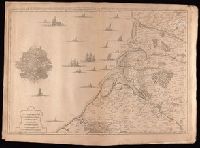
Crépy (Firm) Fricx, Eugène-Henri, d. 1733 Fricx, Eugène-Henri, d. 1733. Cartes des provinces des Pays Bas
Published / Created:
1743
Call Number:
1977 Folio 177
Image Count:
2
Resource Type:
Maps, Atlases & Globes
Description:
"No. 13" in lower right corner, outside of neat line., Bar scales given in "echelle de deux lieues et demie communes de France" and "echelle de deux lieues de Brabant"., From Fricx's Cartes des provinces des Pays Bas, 1744., Prime meridian: Ferro., Relief shown by hachures., Sheet measures 55.3 x 72.3 cm. No. 33 of 34 maps bound together., and Watermark.
Publisher:
Chez Crepy rue S. Jacques a limage S. Pierre,
Subject (Geographic):
Nord-Pas-de-Calais (France)--Maps--Early works to 1800
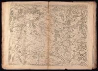
Crépy, Etienne Louis, printer Fricx, Eugène-Henri, d. 1733 Fricx, Eugène-Henri, d. 1733. Cartes des provinces des Pays Bas
Published / Created:
[1744]
Call Number:
1977 Folio 177
Image Count:
2
Resource Type:
Maps, Atlases & Globes
Description:
"11" in lower right corner., From Fricx's Cartes des provinces des Pays Bas, 1744., Relief shown by hachures., Sheet measures 54.6 x 72.5 cm. No. 19 of 34 maps bound together., and Watermark.
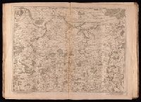
Crépy (Firm) Fricx, Eugène-Henri, d. 1733 Fricx, Eugène-Henri, d. 1733. Cartes des provinces des Pays Bas
Published / Created:
en 1744.
Call Number:
1977 Folio 177
Image Count:
2
Resource Type:
Maps, Atlases & Globes
Description:
"No. 15" in lower right corner, outside of neat line., Bar scales given in "echelle de deux lieues et demie comune de France" and "echelle de deux lieues de Brabant"., From Fricx's Cartes des provinces des Pays Bas, 1744., Prime meridian: Ferro., Relief shown by hachures., Sheet measures 55.3 x 72.3 cm. No. 32 of 34 maps bound together., Title devised by cataloger., and Watermark.
Publisher:
Chez Crepy rue S. Jacques a limage S. Pierre,
Subject (Geographic):
Luxembourg (Belgium)--Maps--Early works to 1800 and Luxembourg (Luxembourg)--Maps--Early works to 1800