Skip to search
Skip to main content
Skip to first result
Search
You Searched For
Date
1700 - 1799
Resource Type
Maps, Atlases & Globes
Date Created
1700 to 1799
New Search
Search Results
Published / Created:
1796
Call Number:
75 1796A
Container / Volume:
BRBL_00396
Image Count:
1
Resource Type:
Maps, Atlases & Globes
Subject (Geographic):
United States--Maps--Early works to 1800
Found in:
Beinecke Rare Book and Manuscript Library > A Geographical View of all the Post Towns in the United States of America and their distances from each other according to the establishment of the Postmaster General, 1796. By Samuel A. Puddock, Accomptant, Boston. B. Callender, Sculp., Boston.
Published / Created:
[1750?]
Call Number:
3211cea 1750
Container / Volume:
BRBL_00055
Image Count:
2
Resource Type:
Maps, Atlases & Globes
Description:
Insets: Falmouth H., Plymouth Hr. Isle of Wight ca. 1:200,000.
Publisher:
Will. Mount and Tho. Page,
Subject (Geographic):
English Channel--Maps--Early works to 1800
Found in:
Beinecke Rare Book and Manuscript Library > A Large Chart of the Channel between England and France ... by Capt. Edmund Halley ...
Published / Created:
1760
Call Number:
771fcm R297 1760
Container / Volume:
BRBL_00714
Image Count:
1
Resource Type:
Maps, Atlases & Globes
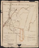
Description:
Color: pen and ink with green detail. and Explanation in bottom right hand side.
Subject (Geographic):
New York--Maps, Manuscript--Early works to 1800
Found in:
Beinecke Rare Book and Manuscript Library > A Map Claverack and Parts adjacent shewing the Claim of John Van Renselaer Esqr. The construction set up on the part of the crown, in the late action of intrustion. Done at New York, 9. Nov. 1760.
Published / Created:
1774
Call Number:
62 1774
Container / Volume:
BRBL_00333
Image Count:
1
Resource Type:
Maps, Atlases & Globes
Publisher:
Printed for Robt. Sayer,
Subject (Geographic):
Ethiopia--Maps--Early works to 1800
Found in:
Beinecke Rare Book and Manuscript Library > A Map of Abyssinia and Nubia, By Samuel Dunn.
Published / Created:
1722]
Call Number:
755 1722A
Container / Volume:
BRBL_00425
Image Count:
1
Resource Type:
Maps, Atlases & Globes
Publisher:
s. n.,
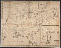
Subject (Geographic):
East (U.S.)--Maps--Early works to 1800
Found in:
Beinecke Rare Book and Manuscript Library > A Map of Carolana and the river of Meschacebe.
Published / Created:
1757
Call Number:
304 1757
Container / Volume:
BRBL_00033
Image Count:
1
Resource Type:
Maps, Atlases & Globes
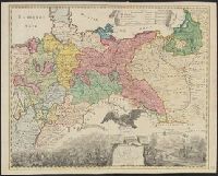
Description:
Preliminary record. and The map (bounded by Frisia, Jutland, Prussia, Poland and extending South to include Silesia and parts of Bavaria and Lotharingia) occupies the upper half of the sheet; the lower half shows an engraved battle scence ...
Subject (Geographic):
Europe, Central--Maps--Early works to 1800
Found in:
Beinecke Rare Book and Manuscript Library > A Map of Central Europe.
Published / Created:
[1795?]
Call Number:
327 1795A
Container / Volume:
BRBL_00072
Image Count:
1
Resource Type:
Maps, Atlases & Globes
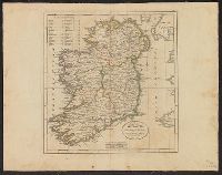
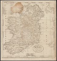
Subject (Geographic):
Ireland--Maps--Early works to 1800
Found in:
Beinecke Rare Book and Manuscript Library > A Map of Ireland ...
Published / Created:
1795
Call Number:
327 1795B
Container / Volume:
BRBL_00072
Image Count:
1
Resource Type:
Maps, Atlases & Globes
Description:
From Carey's American Edition of Guthrie's Geography Improved.
Publisher:
Mathew Carey,
Subject (Geographic):
Ireland--Maps--Early works to 1800
Found in:
Beinecke Rare Book and Manuscript Library > A Map of Ireland according to the best authorities.
Published / Created:
[1798?]
Call Number:
327 1798
Container / Volume:
BRBL_00073
Image Count:
1
Resource Type:
Maps, Atlases & Globes
Subject (Geographic):
Ireland--Maps--Early works to 1800
Found in:
Beinecke Rare Book and Manuscript Library > A Map of Ireland according to the best authorities. Engraved for Plowden's Historical Review of the State of Ireland.
Published / Created:
[1793?]
Call Number:
802 1793
Container / Volume:
BRBL_00542
Image Count:
1
Resource Type:
Maps, Atlases & Globes
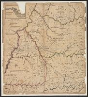
Description:
[Incorrectly dated 1785] and Inset: [part of Ohio] River, ca. 1:60,000, 7 x 11 cm.
Subject (Geographic):
Kentucky--Maps--Early works to 1800
Found in:
Beinecke Rare Book and Manuscript Library > A Map of Kentucky, Drawn from Actual Observations. By John Filson.
Branch:v1.61.6 ,Deployed:2024-06-12T09:55:19-04:00