Skip to search
Skip to main content
Skip to first result
Search
You Searched For
Date
Unknown
Genre
Maps
Date Created
[Missing]
New Search
Search Results
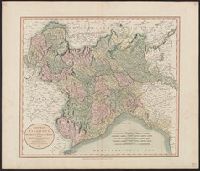
Creator:
Call Number:
401 1811
Container / Volume:
BRBL_00233
Image Count:
1
Resource Type:
Maps, Atlases & Globes
Description:
Hand colored. Stamp: Karpinski-von Wieser Map Collection. Label: 17., Meridian: Greenwich., and Relief shown by hachures.
Subject (Geographic):
Genoa (Italy : Province)--Maps, Milan (Italy : Province)--Maps, Piedmont (Italy)--Maps, and Savoy (France and Italy)--Maps
Found in:
Beinecke Rare Book and Manuscript Library > A new map of Piedmont, the duchies of Savoy and Milan, and the republic of Genoa, with their subdivisions : from the latest authorities / by John Cary.
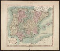
Creator:
Call Number:
39 1801
Container / Volume:
BRBL_00186
Image Count:
1
Resource Type:
Maps, Atlases & Globes
Description:
Appeared in Cary's new universal atlas, London, 1808. and Relief shown pictorially.
Subject (Geographic):
Portugal--Maps and Spain--Maps
Subject (Name):
Cary, John, ca. 1754-1835. Cary's new universal atlas and Hughes, Thomas Lowe,--1925---Ownership
Found in:
Beinecke Rare Book and Manuscript Library > A new map of Spain and Portugal : divided into their respective kingdoms and provinces from the latest authorities / by John Cary, engraver.
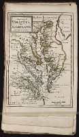
Call Number:
1976 1233
Collection Title:
Forty-two new maps of Asia, Africa, and America ... : all engrav’d, according to the latest
Image Count:
1
Alternative Title:
Virginia and Maryland
Description:
In pencil on verso: 41. and Table of contents for maps 2-20 in section "America" misnumbered.
Subject (Geographic):
Maryland --Maps --Early works to 1800 and Virginia --Maps --Early works to 1800
Subject (Name):
Nicholson, John, d. ca. 1717, bookseller
Subject (Topic):
Atlases --Early works to 1800
Collection Created:
London : Printed for J. Nicholson ..., 1716 ...
Found in:
Beinecke Rare Book and Manuscript Library > A new map of Virginia, and Maryland
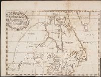
Call Number:
Zc90 +744do
Collection Title:
An account of the countries adjoining to Hudson's Bay, in the North-west part of America
Image Count:
1
Description:
Preceding title page. and Teaching resource: Professor John Mack Faragher, History 141: The American West.
Subject (Geographic):
Great Lakes (North America), Northwest Coast of North America, Northwest Passage, and Northwest, Canadian --Description and travel
Subject (Name):
Fuentes, Bartolome de, 17th cent, Hudson’s Bay Company, and Middleton, Christopher, d. 1770
Subject (Topic):
Fur trade --Canada and Indians of North America --Canada
Collection Created:
London : Printed for J. Robinson, 1744
Found in:
Beinecke Rare Book and Manuscript Library > A new map of part of North America from the latitude of 40 to 68 degrees. Including the late discoveries made on board the Furnace Bomb Ketch in 1742. And the western rivers & lakes falling into Nelson River in Hudson's Bay, as described by Joseph La Fran
Call Number:
1977 +379
Collection Title:
Geografia; cioe, Descrittione vniversale della terra. Partita in due volumi, nel primo de' quali si
Image Count:
1
Alternative Title:
[Geographia. Italian]
Subject (Geographic):
Africa. and Guinea
Subject (Topic):
Geography
Collection Created:
In Padova, Appresso Paolo, & Francesco Galignani, fratelli, 1620-21 [v.1, 1621]
Found in:
Beinecke Rare Book and Manuscript Library > A new map of that part of Africacalled the coast of Guinea ...
Creator:
Call Number:
3614 1799
Container / Volume:
BRBL_00135
Image Count:
1
Resource Type:
Maps, Atlases & Globes
Description:
Appeared in Cary's New universal atlas, London, 1808., Covers East Prussia., and Printed on verso: 36.
Subject (Geographic):
Prussia, East (Poland and Russia)--Maps--Early works to 1800
Subject (Name):
Cary, John, approximately 1754-1835. Cary's new universal atlas and Hughes, Thomas Lowe,--1925---Ownership
Found in:
Beinecke Rare Book and Manuscript Library > A new map of the Kingdom of Prussia : with its divisions into provinces and governments ; from the latest authorities / by John Cary, engraver, 1799.
Published / Created:
Undated
Call Number:
1976 1233
Collection Title:
Twenty four new and accurate maps of the several parts of Europe ... : all (except the last) new
Image Count:
1
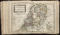
Alternative Title:
The United-Provinces, or Netherlands
Description:
In pencil on verso: 13.
Subject (Geographic):
Netherlands --Maps --Early works to 1800
Subject (Name):
Barker, B. (Benjamin), d. 1764, bookseller, Clements, Henry, d. 1719, bookseller, King, Charles, d. 1735, bookseller, Nicholson, John, d. ca. 1717, bookseller, Parker, Richard, fl. 1692-1725, bookseller, and Tooke, Benjamin, d. 1716, bookseller
Subject (Topic):
Atlases --Early works to 1800
Collection Created:
[London] : Sold by J. Nicholson at the King’s-Arms in Little Britain, Benj. Barker and Charles King ..., Benj. Tooke ..., Hen. Clements ..., R. Parker and Ralph Smith under the Royal-Exchange ..., [1715?]
Found in:
Beinecke Rare Book and Manuscript Library > A new map of the United Provinces or Netherlands &c
Call Number:
1976 1233
Collection Title:
Forty-two new maps of Asia, Africa, and America ... : all engrav’d, according to the latest
Image Count:
1
Alternative Title:
Barbadoes
Description:
In pencil on verso: 35. and Table of contents for maps 2-20 in section "America" misnumbered.
Subject (Geographic):
Barbados --Maps --Early works to 1800
Subject (Name):
Nicholson, John, d. ca. 1717, bookseller
Subject (Topic):
Atlases --Early works to 1800
Collection Created:
London : Printed for J. Nicholson ..., 1716 ...
Found in:
Beinecke Rare Book and Manuscript Library > A new map of the island of Barbadoes, containing all ye parishes, and principal plantations; together with ye forts, lines, batteries, roads, &c
Call Number:
1976 1233
Collection Title:
Forty-two new maps of Asia, Africa, and America ... : all engrav’d, according to the latest
Image Count:
1
Alternative Title:
Jamaica
Description:
In pencil on verso: 37. and Table of contents for maps 2-20 in section "America" misnumbered.
Subject (Geographic):
Jamaica --Maps --Early works to 1800
Subject (Name):
Nicholson, John, d. ca. 1717, bookseller
Subject (Topic):
Atlases --Early works to 1800
Collection Created:
London : Printed for J. Nicholson ..., 1716 ...
Found in:
Beinecke Rare Book and Manuscript Library > A new map of the island of Jamaica
Call Number:
1976 1233
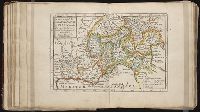
Collection Title:
Twenty four new and accurate maps of the several parts of Europe ... : all (except the last) new
Image Count:
1
Alternative Title:
Lombardy, with Dauphine, Provence, the Cevennes, &c
Description:
In pencil on verso: 21. and Table of contents for maps 20-24 misnumbered.
Subject (Geographic):
Cevennes Mountains (France) --Maps, Dauphine Alps (France), France --Maps --Early works to 1800, Graubuenden (Switzerland), Italy --Maps --Early works to 1800, and Switzerland --Maps --Early works to 1800
Subject (Name):
Barker, B. (Benjamin), d. 1764, bookseller, Clements, Henry, d. 1719, bookseller, King, Charles, d. 1735, bookseller, Nicholson, John, d. ca. 1717, bookseller, Parker, Richard, fl. 1692-1725, bookseller, and Tooke, Benjamin, d. 1716, bookseller
Subject (Topic):
Atlases --Early works to 1800
Collection Created:
[London] : Sold by J. Nicholson at the King’s-Arms in Little Britain, Benj. Barker and Charles King ..., Benj. Tooke ..., Hen. Clements ..., R. Parker and Ralph Smith under the Royal-Exchange ..., [1715?]
Found in:
Beinecke Rare Book and Manuscript Library > A new map of the seats of war in Italy and the Sevennes together with ye territorys about it
Branch:v1.61.6 ,Deployed:2024-06-12T09:55:36-04:00