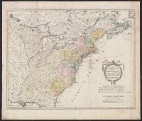
Treize Etats Unis de l'Amerique septentrionale, d'apress les meilleurs & speciales cartes angloises qui ont parues jusqu'ici and XIII Etats Unis de l'Amerique septentrionale, d'apres les meilleurs & speciales cartes angloises qui ont parues jusqu'ici
Description:
"I.M. Schmidt, sc. Nor.", "Mit Römisch Kaÿserl. Allerg. Freÿheit.", Backed with linen., Bar scales given in "Geographische Meilen," "See-Meilen 20 auf einen Grad.," and "Englaendil. Meilen.", Prime meridian: Ferro., and Relief shown pictorially.
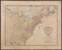
Treize Etats Unis de l'Amerique septentrionale, d'apress les meilleurs & speciales cartes angloises qui ont parues jusqu'ici and XIII Etats Unis de l'Amerique septentrionale, d'apres les meilleurs & speciales cartes angloises qui ont parues jusqu'ici
Description:
"I.M. Schmidt, sc. Nor.", "Mit Römisch Kaÿserl. Allerg. Freÿheit.", Bar scales given in "Geographische Meilen," "See-Meilen 20 auf einen Grad.," and "Englaendil. Meilen.", and Franklin Collection no. 131 1784-7. Sheet measures 54.5 x 67.1 cm.
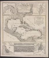
Carte de isles de l'Amérique, Delineatio munimenti et portus S. Augustini, Delineatio portus mexicani Vera Cruz, Technographia urbis San-Domingo, and Urbs capitalis regni mexicani dicta Mexico
Description:
Central map (Carte des isles de l'Amérique). Cross Collection no. 247., Central map has title: Carte des isles de l'Amérique et deplusieurs pays de terre ferme situés au devant de ces isles & autour du Golfe de Mexique / dressée sur un grand nombre de cartes particuliéres ... par le sr. d'Anville, géographe ordre. du roi, mars 1731., Large central map shows southern United States, Mexico, Central America, northern South America, and West Indies. Surrounding maps show the Isthmus of Panama, Saint Augustine, Fla., San Domingo (present-day Haiti), Mexico City, and Vera Cruz, Mexico., Relief shown pictorially., and Surrounding maps have titles: Delineatio munimenti et portus S. Augustini -- Technographia urbis San-Domingo -- Urbs capitalis regni mexicani dicta Mexico -- Delineatio portus mexicani Vera Cruz -- [Isthmus of Panama].
Publisher:
Homann Heirs,
Subject (Geographic):
Caribbean Area--Maps--Early works to 1800, Central America--Maps--Early works to 1800, Haiti--Maps--Early works to 1800, Mexico City (Mexico)--Maps--, and Veracruz (Veracruz-Llave, Mexico)--Maps--Early works to 1800
Subject (Name):
Anville, Jean Baptiste Bourguignon d', 1697-1782. Carte des isles de l'Amérique and Homann Erben (Firm)
Mappe-monde qui représente les deux hemisphères savoir celui de l'orient et celui de l'occident, tirée des quatre cartes générales de feu M. le profess. Hasius, Planiglobii terrestris mappa vniversalis, and Schul-Atlas von zwantzig General- und Special-Lan
Description:
Appears in Homann heirs' Schul-atlas von zwantzig general-und special-land karten ... Cf. Phillips, no. 293., Imperfect: torn along fold, with no loss of text. Shee, Map colored to show distribution of religions., and Title in Latin and French; legend in German.
Publisher:
Homann Erben],
Subject (Name):
Hase, Johann Matthias, 1684-1742 and Homann Erben (Firm)
Subject (Topic):
Religion--Maps--Early works to 1800 and World maps--Early works to 1800