Search
You Searched For
Search Results
- Creator:
- Lanfiere, Thomas
- Published / Created:
- [1665?]
- Call Number:
- BrSides By6 1665
- Image Count:
- 1
- Found in:
- Beinecke Rare Book and Manuscript Library > A Discription of plain-dealing, time, and death, which all men ought to mind whilst they do live on earth ...
- Published / Created:
- [1774]
- Call Number:
- 76 1774
- Container / Volume:
- BRBL_00729
- Image Count:
- 1
- Resource Type:
- Maps, Atlases & Globes
- Found in:
- Beinecke Rare Book and Manuscript Library > A Map of the most inhabited part of New England [cartographic material] : containing the provinces of Massachusets Bay and New Hampshire with the colonies of Conecticut and Rhode Island divided into counties and townships : The whole composed from actual
- Published / Created:
- [1774]
- Call Number:
- 76 1774
- Container / Volume:
- BRBL_00729
- Image Count:
- 2
- Resource Type:
- Maps, Atlases & Globes
- Found in:
- Beinecke Rare Book and Manuscript Library > A Map of the most inhabited part of New England [cartographic material] : containing the provinces of Massachusets Bay and New Hampshire with the colonies of Conecticut and Rhode Island divided into counties and townships : The whole composed from actual
- Published / Created:
- [1774]
- Call Number:
- 76 1774
- Container / Volume:
- BRBL_00443
- Image Count:
- 2
- Resource Type:
- Maps, Atlases & Globes
- Found in:
- Beinecke Rare Book and Manuscript Library > A Map of the most inhabited part of New England [cartographic material] : containing the provinces of Massachusets Bay and New Hampshire with the colonies of Conecticut and Rhode Island divided into counties and townships : The whole composed from actual
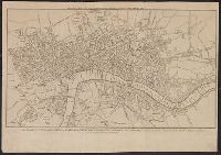
- Published / Created:
- [1780]
- Call Number:
- 32 L84 1780
- Container / Volume:
- BRBL_00048
- Image Count:
- 1
- Resource Type:
- Maps, Atlases & Globes
- Found in:
- Beinecke Rare Book and Manuscript Library > A New & Correct Plan of the Cities of London and Westminister, with the Borough of Southwark ...
- Creator:
- Blodget, Samuel, 1724-1807
- Published / Created:
- February the 2d, 1756.
- Call Number:
- 771hc H864 1756
- Container / Volume:
- BRBL_00495
- Image Count:
- 1
- Resource Type:
- Maps, Atlases & Globes
- Found in:
- Beinecke Rare Book and Manuscript Library > A Prospective view of the battle fought near Lake George, on the 8th of Sepr. 1755 : between 2000 English, with 250 Mohawks, under the command of Gen. Johnson: & 2500 French & indians under the command of Genl. Dieskau in which the English were victorious
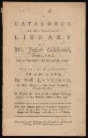
- Creator:
- Langford, Mr. (Abraham), 1711-1774.
- Published / Created:
- [1776]
- Call Number:
- X348 L264 1776
- Image Count:
- 14
- Found in:
- Beinecke Rare Book and Manuscript Library > A catalogue of the valuable library of Mr. Josiah Colebrook, deceased : F.R.S. and late treasurer of the Antiquarian Society, which ... will be sold by auction, by Mess. Langford ... on Tuesday the 20th of this instant February 1776, and the two following evenings ...
- Published / Created:
- [1783?]
- Call Number:
- 70 1783A
- Container / Volume:
- BRBL_00356
- Image Count:
- 3
- Resource Type:
- Maps, Atlases & Globes
- Found in:
- Beinecke Rare Book and Manuscript Library > A chart of North and South America : including the Atlantic and Pacific Oceans, with the nearest coasts of Europe, Africa and Asia : according to the preliminary articles of peace signed at Versailles, 20 Jany. 1783.
- Published / Created:
- [1783?]
- Call Number:
- 70 1775
- Container / Volume:
- BRBL_00686
- Image Count:
- 3
- Resource Type:
- Maps, Atlases & Globes
- Found in:
- Beinecke Rare Book and Manuscript Library > A chart of North and South America : including the Atlantic and Pacific Oceans, with the nearest coasts of Europe, Africa and Asia : according to the preliminary articles of peace signed at Versailles, 20 Jany. 1783.