Skip to search
Skip to main content
Skip to first result
Search
You Searched For
Date
1600 - 1799
Format
cartographic
Date Created
1600 to 1799
New Search
Search Results
Creator:
Published / Created:
1775?-1781?]
Call Number:
1983 Folio 25
Image Count:
3
Resource Type:
Maps, Atlases & Globes
Abstract:
A made-up collection of charts, plans and views, partly hand colored, from the Atlantic Neptune comprising [v. 1]: the charts of the South East Coast of Nova Scotia, with the title page of The charts of the coast and harbors of New England, 1781 bound in front (31 items, dated between 1777 and 1781). [v. 2]: Charts of the coast and harbours in the Gulph and river of St. Lawrence, 1780, including the charts of the coast of New England (36 items, dated between 1775 and 1781). [v. 3]: Charts of several harbours and divers parts of the coast of North America from New York south westwards to the Gulph of Mexico, 1780, including some 16 charts belonging to the New England part of the work (35 items, dated between 1776 and 1781). General title page wanting.
Description:
Includes indexes.
Publisher:
The Admiralty,
Subject (Geographic):
North America--Maps and North America--Pictorial works
Subject (Topic):
Nautical charts--Atlantic Coast (North America)
Found in:
Beinecke Rare Book and Manuscript Library > [The Atlantic Neptune : published for the use of the Royal Navy Great Britain / by Joseph F.W. Des Barres, esq.].
Published / Created:
[1779]
Call Number:
787hca Sa91 1779P
Container / Volume:
BRBL_00730
Image Count:
1
Resource Type:
Maps, Atlases & Globes
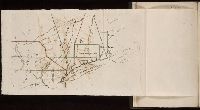
Description:
"Nota" with details of changes in positions during the siege., Inset: "Explication des lettres du plan.", Map shows fortifications around the city, the positions of the French, American and British batteries, roads to surrounding towns, and the Savannah and Augustine rivers., Pen and ink ms. signed "O'Connor"., and Title supplied by cataloger.
Subject (Geographic):
Savannah (Ga.)--History--Siege, 1779--Maps, Manuscript--Early works to 1800 and Savannah (Ga.)--Maps, Manuscript--Early works to 1800
Found in:
Beinecke Rare Book and Manuscript Library > [The siege of Savannah, 1779].
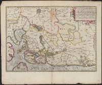
Published / Created:
1774
Call Number:
Pequot Sm95
Collection Title:
An examination of the Connecticut claim to lands in Pennsylvania : with an appendix, containing
Image Count:
1
Description:
Between p. 30-31
Subject (Geographic):
Connecticut., Massachusetts., and Rhode Island
Subject (Topic):
Susquehanna Claim, 1753-1808
Collection Created:
Philadelphia : Printed by J. Crukshank, 1774
Found in:
Beinecke Rare Book and Manuscript Library > [Untitled map depicting southern New England and the coastline]
Creator:
Published / Created:
[1739?]
Call Number:
1973 folio 44
Collection Title:
Plan de Paris commence l’annee 1734. Dessine et gravesous les ordres de Messire Michel Etienne
Image Count:
1
Resource Type:
Maps, Atlases & Globes
Description:
Consists of 20 numbered sectional plans of Paris. and Scale about 1:1800.
Subject (Geographic):
Paris (France) --Maps
Subject (Topic):
Architecture --France --Paris
Collection Created:
[Paris? 1739?]
Found in:
Beinecke Rare Book and Manuscript Library > [Untitled sectional plan of Paris]
Creator:
Published / Created:
[1739?]
Call Number:
1973 folio 44
Collection Title:
Plan de Paris commence l’annee 1734. Dessine et grave sous les ordres de Messire Michel Etienne
Image Count:
1
Resource Type:
Maps, Atlases & Globes
Description:
Consists of 20 numbered sectional plans of Paris. and Scale about 1:1800.
Subject (Geographic):
Jardin des Tuileries (Paris, France), Paris (France) --Maps, and Tuileries Palace (Paris, France)
Subject (Topic):
Architecture --France --Paris
Collection Created:
[Paris? 1739?]
Found in:
Beinecke Rare Book and Manuscript Library > [Untitled sectional plan of Paris]
Published / Created:
[1605]
Call Number:
3361 1605
Container / Volume:
BRBL_00088
Image Count:
2
Resource Type:
Maps, Atlases & Globes
Description:
Preliminary record. and Verso: Text.
Subject (Geographic):
West Flanders (Belgium)--Maps--Early works to 1800
Found in:
Beinecke Rare Book and Manuscript Library > [West Flanders] Petrus Koerius coelavit.
Published / Created:
[1700]
Call Number:
11 1700A
Container / Volume:
BRBL_00004
Image Count:
1
Resource Type:
Maps, Atlases & Globes
Description:
Preliminary record.
Subject (Geographic):
World--Maps--Early works to 1800
Found in:
Beinecke Rare Book and Manuscript Library > [World Map] Portugal - The Country that has contributed most to geographic knowledge of the Globe in the course of one century she discovered and explored nearly two-thirds of the inhabited Globe.
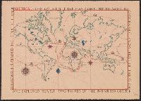
Published / Created:
[Ca. 1612]
Call Number:
Taylor 258
Collection Title:
Descriptio ac delineatio geographica detectionis freti, sive, transitus ad occasum supra terras
Image Count:
1
Description:
Bound in after p. [8]., Map folded irregularly., Printed on recto in lower right corner: B., and Scale [ca. 1:160,000,000].
Subject (Name):
Quieros, Pedro Fernandes de, d. 1615
Subject (Topic):
World maps --Early works to 1800
Collection Created:
Amsterodami Ex officina Hesse lij Gerardi. Anno 1613
Found in:
Beinecke Rare Book and Manuscript Library > [World map]
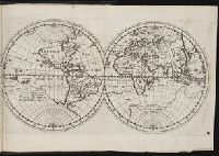
Published / Created:
1606
Call Number:
Taylor 237
Collection Title:
Regimiento de navegacion mando hazer el rei nvestro senor por orden de sv conseio real de las
Image Count:
1
Description:
Right edge of map has been folded unevenly., Scale [ca. 1:141,000,000]., and Some place names appear inverted on map.
Subject (Name):
Garcia de Cespedes, Andres, d. 1611
Subject (Topic):
Navigation --Early works to 1800 and World maps --Early works to 1800
Collection Created:
Madrid, En casa de I. de la Cuesta, 1606
Found in:
Beinecke Rare Book and Manuscript Library > [World map]
Published / Created:
[Ca. 1612]
Call Number:
Pequot G325
Collection Title:
Descriptio ac delineatio geographica detectionis freti, sive, transitus ad occasum supra terras
Image Count:
1
Description:
Bound in after p. [8]., Printed on recto: "B" in lower right margin., and Scale [ca. 1:160,000,000].
Subject (Topic):
World maps --Early works to 1800
Collection Created:
Amsterodami Ex officina Hesse lij Gerardi. Anno 1613
Found in:
Beinecke Rare Book and Manuscript Library > [World map]
Branch:v1.61.8 ,Deployed:2024-06-20T11:15:02-04:00