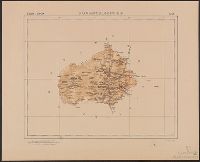
Mexico. Dirección de Estudios Geográficos y Climatológicos
Published / Created:
[1922]
Call Number:
8821 1922
Container / Volume:
BRBL_00653
Image Count:
2
Resource Type:
Maps, Atlases & Globes
Description:
"No. 2.", Accompanied by physiographic plate covering same area, showing only relief and drainage (1 sheet : col. ; 48 cm.)., Appears in Atlas geográfico de la República Mexicana., and Relief shown by shading.
Publisher:
La Dirección,
Subject (Geographic):
Aguascalientes (Mexico : State)--Maps
Subject (Name):
Mexico. Dirección de Estudios Geográficos y Climatológicos. Atlas geográfico de la República Mexicana
The West-India pilot: containing piloting directions for Port Royal and Kingston harbours in
Image Count:
1
Subject (Geographic):
Atlantic Ocean --Maps --Early works to 1800, Puerto Rico --Maps --Early works to 1800, and West Indies --Maps --Early works to 1800
Subject (Topic):
Harbors --Atlantic Coast (North America) --Maps --Early works to 1800, Nautical charts --Atlantic Coast (North America) --Early works to 1800, Nautical charts --Caribbean Area --Early works to 1800, Nautical charts --West Indies --Early works to 1800, Pilot guides --Atlantic Coast (North America) --Early works to 1800, Pilot guides --Caribbean Area --Early works to 1800, and Pilot guides --West Indies --Early works to 1800
Collection Created:
London : Printed for the author and sold by S. Hooper ..., MDCCLXXI [1771]
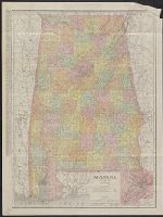
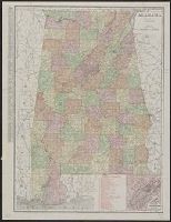
Rand McNally & Co.'s indexed county and township pocket map and shippers' guide of Alabama and Rand McNally and Co.'s indexed county and township pocket map and shippers' guide of Alabama
Description:
Includes key to railroads numbered 1-160 (with gaps in numbering) beneath added title: Alabama railroads., Inset (12 x 11 cm.): Environs of Birmingham., and Without accompanying index. Numerous cities on map with printed circles.