Skip to search
Skip to main content
Skip to first result
Search
You Searched For
Date
1600 - 1799
Resource Type
Maps, Atlases & Globes
Date Created
1600 to 1799
New Search
Search Results
Published / Created:
1704
Call Number:
Cxb e678ge
Collection Title:
The history of the bucaniers of America : from the first original down to this time; written in
Image Count:
1
Resource Type:
Maps, Atlases & Globes
Alternative Title:
[Piratas de América. English]
Publisher:
Printed for T. Newborough [etc.]
Collection Created:
London : Printed for T. Newborough [etc.],
Found in:
Beinecke Rare Book and Manuscript Library > A Map of the Countrey and Citty of Panama. Part 3: Chap: 5.
Published / Created:
1795]
Call Number:
18 1795A
Container / Volume:
BRBL_00012
Image Count:
1
Resource Type:
Maps, Atlases & Globes
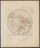
Description:
Engraved for Carey's Edition of Guthrie's Geography Improved.
Publisher:
Mathew Carey,
Subject (Geographic):
Arctic Regions--Maps--Early works to 1800
Found in:
Beinecke Rare Book and Manuscript Library > A Map of the Countries situate about the North Pole as far as the 50th Degree of North Latitude. W. Barker, sculp.
Published / Created:
1795]
Call Number:
18 1795
Container / Volume:
BRBL_00012
Image Count:
1
Resource Type:
Maps, Atlases & Globes
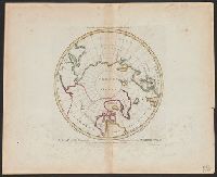
Description:
Engraved for Carey's Edition of Guthrie's Geography Improved.
Publisher:
Mathew Carey,
Subject (Geographic):
Arctic Regions--Maps--Early works to 1800
Found in:
Beinecke Rare Book and Manuscript Library > A Map of the Countries situate about the North Pole as far as the 50th Degree of North Latitude. W. Barker, sculp.
Published / Created:
[1770?]
Call Number:
771ad C38 1770
Container / Volume:
BRBL_00714
Image Count:
1
Resource Type:
Maps, Atlases & Globes
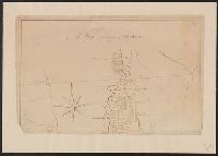
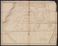
Description:
Color: pen and ink drawing with yellow detail., Lower half lacking., and Ms. cadastral map showing lands along Lake Champlain belonging to English soldiers.
Subject (Geographic):
New York--Maps, Manuscript--Early works to 1800
Found in:
Beinecke Rare Book and Manuscript Library > A Map of the County of Charlotte.
Published / Created:
1768
Call Number:
771 Al13 1768
Container / Volume:
BRBL_00713
Image Count:
2
Resource Type:
Maps, Atlases & Globes
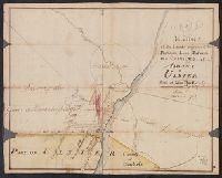
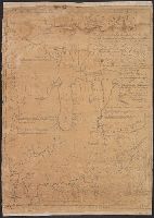
Description:
Color: pen and ink, some yellow, blue and pink shading. and Notes: Clipping from Revolutionary war period, manuscript New York maps.
Subject (Geographic):
Albany (N.Y.)--Maps, Manuscript--Early works to 1800
Found in:
Beinecke Rare Book and Manuscript Library > A Map of the Lands Adjoining the Partition Line between Countys of Albany & Ulster Done of New York, 1768, Will Cockburn.
Published / Created:
1765
Call Number:
771 Al13 1765
Container / Volume:
BRBL_00713
Image Count:
2
Resource Type:
Maps, Atlases & Globes
Description:
Clipping from revolutionary war period manuscript New York maps. and Color: pen and ink drawing.
Subject (Geographic):
Albany (N.Y.)--Maps, Manuscript--Early works to 1800
Found in:
Beinecke Rare Book and Manuscript Library > A Map of the Lands on the Southside of the County of Albany between the Blue Mountains and the Sawkill. Surred in the month of Oct. 1765, by Will Cockburn.
Published / Created:
[1785?]
Call Number:
755 1785F
Container / Volume:
BRBL_00435
Image Count:
1
Resource Type:
Maps, Atlases & Globes
Description:
Mounted.
Publisher:
Engraved and Printed by John Fitch,
Subject (Geographic):
East (U.S.)--Maps--Early works to 1800
Found in:
Beinecke Rare Book and Manuscript Library > A Map of the North West parts of the United States of America ... [by] John Fitch ...
Published / Created:
1774
Call Number:
771 1774
Container / Volume:
BRBL_00713
Image Count:
1
Resource Type:
Maps, Atlases & Globes
Description:
Color: water color.
Subject (Geographic):
New York--Maps--Early works to 1800
Found in:
Beinecke Rare Book and Manuscript Library > A Map of the Province of New York as divided into Counties together with the adjacent provinces. Compiled from the latest Maps and Actual Surveys. Will:Cockburn.
Published / Created:
[1790?]
Call Number:
32 1790
Container / Volume:
BRBL_00044
Image Count:
1
Resource Type:
Maps, Atlases & Globes
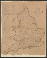
Publisher:
P. Wogan,
Subject (Geographic):
England--Maps--Early works to 1800
Found in:
Beinecke Rare Book and Manuscript Library > A Map of the Roads of England and Wales.
Published / Created:
[1795]
Call Number:
801 1795
Container / Volume:
BRBL_00541
Image Count:
1
Resource Type:
Maps, Atlases & Globes
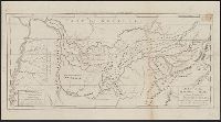
Description:
Engraved for Carey's American Edition of Guthrie's Geography Improved. and J.T. Scott Sculp.
Subject (Geographic):
Tennessee--Maps--Early works to 1800
Found in:
Beinecke Rare Book and Manuscript Library > A Map of the Tennassee State formerly Part of North Carolina taken Chiefly from Survey by Genl. Smith & others.
Branch:v1.61.6 ,Deployed:2024-06-12T09:55:19-04:00