
You Searched For
« Previous
| 1 - 10 of 50 |
Next »
Search Results
- Creator:
- Revere, Paul, 1735-1818
West, Benjamin, 1738-1820 - Published / Created:
- 1774 December
- Call Number:
- Vanderbilt 147
- Collection Title:
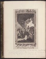
- An historical account of the expedition against the Ohio Indians, in the year 1764. Under the
- Image Count:
- 1
- Description:
- Engraved for Royl. Amern. Mag. Vol. I, No. Xix by P. Revere.
- Subject (Geographic):
- Fort Pitt (Pa.) --History, Ohio River Valley --History --Revolution, 1775-1783, and Pennsylvania --History
- Subject (Name):
- Bouquet, Henry, 1719-1765 and Hutchins, Thomas, 1730-1789
- Subject (Topic):
- Bouqet’s Expedition, 1764, Bushy Run, Battle of, Pa., 1763, Indians of North America --Wars --1750-1815, and Indians --Warfare
- Collection Created:
- Philadelphia, Printed and sold by W. Bradford, 1765
- Found in:
- Beinecke Rare Book and Manuscript Library > A Conference held between some Indian chiefs and Colonel Bouquet in the year 1764

- Creator:
- Tiddeman, Mark
- Call Number:
- 1973 Folio 116
- Collection Title:
- The English pilot: describing the West-India navigation, from Hudson's-Bay to the river Amazones
- Image Count:
- 2
- Subject (Geographic):
- Atlantic Ocean --Maps --Early works to 1800 and Virginia --Maps --Early works to 1800
- Subject (Topic):
- Navigation --Early works to 1800, Pilot guides --Atlantic Coast (U.S.) --Early works to 1800, and Pilot guides --Caribbean Area --Early works to 1800
- Collection Created:
- London :
- Found in:
- Beinecke Rare Book and Manuscript Library > A draught of Virginia from the capes to York in York River and to Kuiquotan or Hamton in James River

- Call Number:
- 1973 Folio 116
- Collection Title:
- The English pilot: describing the West-India navigation, from Hudson's-Bay to the river Amazones
- Image Count:
- 1
- Description:
- Imperfect: mutilated with some loss of image.
- Subject (Geographic):
- Africa, West --Maps --Early works to 1800, Atlantic Ocean --Maps --Early works to 1800, New England --Maps --Early works to 1800, Newfoundland and Labrador --Maps --Early works to 1800, Portugal --Maps --Early works to 1800, South America --Maps --Early works to 1800, and West Indies --Maps --Early works to 1800
- Subject (Topic):
- Navigation --Early works to 1800, Pilot guides --Atlantic Coast (U.S.) --Early works to 1800, and Pilot guides --Caribbean Area --Early works to 1800
- Collection Created:
- London :
- Found in:
- Beinecke Rare Book and Manuscript Library > A general chart of the western ocean

- Call Number:
- 1974 Folio 72
- Collection Title:
- The English pilot: describing the West-India navigation, from Hudson's-Bay to the river Amazones
- Image Count:
- 2
- Description:
- Mathematical notations on one verso.
- Subject (Geographic):
- Africa, West --Maps --Early works to 1800, Atlantic Coast (North America) --Maps --Early works to 1800, Atlantic Ocean --Maps --Early works to 1800, Newfoundland and Labrador --Maps --Early works to 1800, South America --Maps --Early works to 1800, and West Indies --Maps --Early works to 1800
- Subject (Topic):
- Navigation --Early works to 1800, Pilot guides --Atlantic Coast (U.S.) --Early works to 1800, and Pilot guides --Caribbean Area --Early works to 1800
- Collection Created:
- London : Printed for W. and J. Mount, T. Page and son, on Tower-Hill, MDCCLX [1760]
- Found in:
- Beinecke Rare Book and Manuscript Library > A generall chart of the western ocean
- Call Number:
- QE533 D56
- Collection Title:
- A Moral and Philosophical History of Comets... including an Accurate Description of the Present
- Image Count:
- 3
- Description:
- Includes final page of A compendious view of the astronomy of comets ...
- Subject (Name):
- Newman, H
- Subject (Topic):
- Comets
- Collection Created:
- London : Printed for the author; sold by J. Fairburn, 1811
- Found in:
- Beinecke Rare Book and Manuscript Library > A history of comets, &c

- Call Number:
- 1974 Folio 72
- Collection Title:
- The English pilot: describing the West-India navigation, from Hudson's-Bay to the river Amazones
- Image Count:
- 1
- Subject (Geographic):
- Africa --Maps --Early works to 1800, Antarctic Ocean --Maps, Atlantic Ocean --Maps --Early works to 1800, Europe --Maps --Early works to 1800, North America --Maps --Early works to 1800, and South America --Maps --Early works to 1800
- Subject (Topic):
- Navigation --Early works to 1800, Pilot guides --Atlantic Coast (U.S.) --Early works to 1800, and Pilot guides --Caribbean Area --Early works to 1800
- Collection Created:
- London : Printed for W. and J. Mount, T. Page and son, on Tower-Hill, MDCCLX [1760]
- Found in:
- Beinecke Rare Book and Manuscript Library > A new and correct chart of the western and southern oceans

- Call Number:
- 1974 Folio 72
- Collection Title:
- The English pilot: describing the West-India navigation, from Hudson's-Bay to the river Amazones
- Image Count:
- 1
- Subject (Geographic):
- Africa --Maps --Early works to 1800, Atlantic Ocean --Maps --Early works to 1800, Central America --Maps --Early works to 1800, Great Britain --Maps --Early works to 1800, Newfoundland and Labrador --Maps --Early works to 1800, North America --Maps --Early works to 1800, South America --Maps --Early works to 1800, Spain --Maps --Early works to 1800, and West Indies --Maps --Early works to 1800
- Subject (Topic):
- Navigation --Early works to 1800, Pilot guides --Atlantic Coast (U.S.) --Early works to 1800, and Pilot guides --Caribbean Area --Early works to 1800
- Collection Created:
- London : Printed for W. and J. Mount, T. Page and son, on Tower-Hill, MDCCLX [1760]
- Found in:
- Beinecke Rare Book and Manuscript Library > A new generall chart for the West Indies

- Call Number:
- 1973 Folio 116
- Collection Title:
- The English pilot: describing the West-India navigation, from Hudson's-Bay to the river Amazones
- Image Count:
- 1
- Subject (Geographic):
- Africa --Maps --Early works to 1800, Atlantic Ocean --Maps --Early works to 1800, Central America --Maps --Early works to 1800, Great Britain --Maps --Early works to 1800, Newfoundland and Labrador --Maps --Early works to 1800, North America --Maps --Early works to 1800, South America --Maps --Early works to 1800, Spain --Maps --Early works to 1800, and West Indies --Maps --Early works to 1800
- Subject (Topic):
- Navigation --Early works to 1800, Pilot guides --Atlantic Coast (U.S.) --Early works to 1800, and Pilot guides --Caribbean Area --Early works to 1800
- Collection Created:
- London :
- Found in:
- Beinecke Rare Book and Manuscript Library > A new generall chart for the West Indies

- Call Number:
- 1973 Folio 114
- Collection Title:
- The English pilot: describing the West-India navigation, from Hudson's-Bay to the river Amazones
- Image Count:
- 2
- Resource Type:
- Maps, Atlases & Globes
- Subject (Geographic):
- Africa --Maps --Early works to 1800, Atlantic Ocean --Maps --Early works to 1800, Central America --Maps --Early works to 1800, Great Britain --Maps --Early works to 1800, Newfoundland and Labrador --Maps --Early works to 1800, North America --Maps --Early works to 1800, South America --Maps --Early works to 1800, Spain --Maps --Early works to 1800, and West Indies --Maps --Early works to 1800
- Subject (Topic):
- Navigation --Early works to 1800, Pilot guides --Atlantic Coast (U.S.) --Early works to 1800, and Pilot guides --Caribbean Area --Early works to 1800
- Collection Created:
- London : Printed for W. and J. Mount, T. Page and son, on Tower-Hill, MDCCLIX [1759]
- Found in:
- Beinecke Rare Book and Manuscript Library > A new generall chart for the West Indies