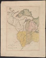
"Entered according to Act of Congress in the year 1866 by A. Lindenkohl, in the Clerk's Office in the District Court of the Southern District of New York." and Mounted on linen paper. Pasted across header: Distances between the principal cities of the Souther
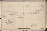
Harbour of St. Thomas, the lighthouse bearing N. by E. 1/2 E. 1/3 of a mile, and the signal station N.W. 1/2 N. 3/4 of a mile, St. Thomas Harbour, and View of the Dog Islets taken from the Tow Rock
Description:
Chart shows Virgin Islands and eastern end of Puerto Rico.
Publisher:
James Imray & Son, 102, Minories,
Subject (Geographic):
Puerto Rico--Maps, Saint Thomas (V.I.)--Maps, and Virgin Islands--Maps
Subject (Name):
James Imray and Son
Subject (Topic):
Views, City (Saint Thomas, V.I) and Views, Topographical (V.I.)