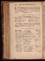
General history of the robberies and murders of the most notorious pyrates
Description:
Attributed to Defoe by Professor John R. Moore of Indiana university. and The frontispiece noted by Sabin, and found in the 1st and 3d editions are wanting in this copy.
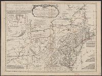
Differs from other copies in absence of Connecticut River north of "Great Falls." Also differs in coloration of boundaries: Ohio and Kentucky Rivers are colored as boundaries; Pennsylvania extends north to a line at approximately 42⁰ 40ʹ; Maryland extends
[American maps ; v. 3, no. 22], Canada from the French surveys with the frontiers of New York and New England., and Library of Congress. American maps ; v. 3, no. 22.
Description:
Relief shown pictorially and by hachures. and Shows the Canadian-United States border from Lake Ontario along the St. Lawrence River to 45₋p0₋s N. latitude, east to the Connecticut River, and northeast along the "Height of the land." Coverage of areas away fr
Subject (Geographic):
Canada--Boundaries--United States--Maps--Early works to 1800, New York (State)--Maps--Early works to 1800, Québec (Province)--Maps--Early works to 1800, and United States--History--Revolution, 1775-1783--British forces
Printed for the author, by J. Dixwell, in St. Martin's Lane: and sold by Mr. A. Cozens, no. 4, Leicester Street, Leicester Fields; and J. Dodsley, in Pall Mall
Begins: The devil has left his puritanical dress., On the flood of scurrilous pamphlets which appeared when the censorship of the press was not renewed after the dissolution of Parliament., Printed in 2 columns., and Reprinted in Bagford ballads, v.2, p. 715-719.