Carte géographique, statistique et historique des possessions Russes
Description:
From Buchon's Atlas géographique, statistique, historique et chronologique des deux Amériques et des îles adjacentes. 1825., In upper right: No. IV., and Includes inset of "Partie occidentale des îles Aleutiennes" and text surrounding map.
Publisher:
fonderie et imprimerie de J. Carez,
Subject (Geographic):
Alaska--Maps
Subject (Name):
Arnoul, Buchon, J. A. C. (Jean Alexandre C.), 1791-1846. Atlas géographique, statistique, historique et chronologique des deux Amériques et des îles adjacentes, Carez, J, and Le Gagneur
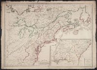
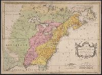
Carte des possessions angloises et françoises du continent de l'Amérique septentrionale
Description:
"On trouvera dans le troisiéme volume de la Nouvelle introduction à la géographie moderne ..." at bottom., Appeared in Jean Palairet's Atlas methodique., Prime meridians: Ferro and London., Relief shown pictorially., and Variant with "Explication" in French and English and with additional boundary lines with titles in French drawn horizontally across the map.
Publisher:
[Jean Palairet],
Subject (Geographic):
France--Colonies--America--Maps--Early works to 1800., Great Britain--Colonies--America--Maps--Early works to 1800., North America--Maps--Early works to 1800., and United States--History--French and Indian War, 1755-1763--Maps
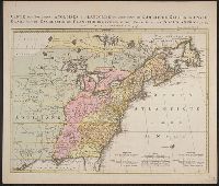
Hand col. On sheet 54 x 73 cm. Recto: Date in title cartouche changed to "1763" in ink ms.; other annotations in ink ms.; numbered "14" in ink ms. Verso: Numbered "14" in ink ms. Labeled "Améri and Printed information matches description in Tooley.
Publisher:
Chez Mrs. Nourse, Vaillant, Millar, Rocque & autres ... Mr. Néaulme ... Mr. P. Gosse,
Subject (Geographic):
France--Colonies--America--Maps--Early works to 1800, Great Britain--Colonies--America--Maps--Early works to 1800, North America--Maps--E, and United States--History--French and Indian War, 1755-1763--Maps--Early works to 1800
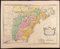
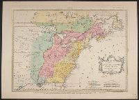
Carte des possessions angloises et françoises du continent de l'Amérique septentrionale
Description:
Appears in Palairet's Atlas methodique, 1755. Bottom margin: "On trouvera dans le troisiéme volume de la Nouvelle introduction, Copy 1: Hand col. Sheet measures 58 x 72 cm. Verso: Stamped "Yale Horace Brown 1900S"., and Matches description in Tooley.
Publisher:
Chez Mrs. Nourse, Vaillant, Millar, Rocque & Sayer ... Neaulme & Covens & Mortier ... Mr. P. Gosse,
Subject (Geographic):
France--Colonies--America--Maps--Early works to 1800, Great Britain--Colonies--America--Maps--Early works to 1800, North America--Maps--E, and United States--History--French and Indian War, 1755-1763--Maps--Early works to 1800
Subject (Name):
Cóvens et Mortier, Gosse, Pierre, 1718-1794, Kitchin, Thomas, 1718-1784, engraver, Millar, Andrew, 1707-1768, Néaulme, Jean, 1694-1780, Nourse, J. (John), -1780, and Rocque, John, -1762
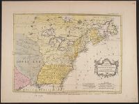
Carte des possessions angloises et françoises du continent de l'Amérique septentrionale
Description:
Appears in Palairet's Atlas methodique, 1755. Bottom margin: "On trouvera dans le troisiéme volume de la Nouvelle introduction à la géographie moderne ... "
Publisher:
Chez Mrs. Nourse, Vaillant, Millar, Rocque & Sayer ... Neaulme & Covens & Mortier ... Mr. P. Gosse,
Subject (Geographic):
France--Colonies--America--Maps--Early works to 1800, Great Britain--Colonies--America--Maps--Early works to 1800, North America--Maps--E, and United States--History--French and Indian War, 1755-1763--Maps--Early works to 1800
Subject (Name):
Cóvens et Mortier, Gosse, Pierre, 1718-1794, Kitchin, Thomas, 1718-1784, engraver, Millar, Andrew, 1707-1768, Néaulme, Jean, 1694-1780, Nourse, J. (John), -1780, and Rocque, John, -1762
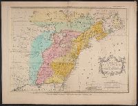
"On trouvera dans le troisiéme volume de la Nouvelle introduction à la géographie moderne ..." at bottom., Appeared in Jean Palairet's Atlas methodique., Mounted on heavy paper. On sheet 44 x 60 cm. Stamp on verso: Yale Horace Brown 1900S., Prime meridians: Ferro and London. Coordinates converted by cataloger to express longitude as measured from the Greenwich meridian., Relief shown pictorially., and Variant with "Explication" in French only.
Subject (Geographic):
France--Colonies--America--Maps--Early works to 1800., Great Britain--Colonies--America--Maps--Early works to 1800., North America--Maps--Early works to 1800., and United States--History--French and Indian War, 1755-1763--Maps--Early works to 1800.
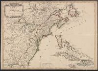
Kaart van de Engelsche en Fransche bezittingen in het vaste land van Noord America. and Possessions angloises & françoises du continet de l'Amérique septentrionale.
Description:
Based on Jean Palairet's Carte des possessions angloises françoises du continent de l'Amérique septentrionale, 1755., Hand colored., LC copy 2 accompanied by Jean Palairet's Beknopte beschr, Prime meridian: London and Île de Fer., and Relief shown pictorially.
Publisher:
Chez R. et J. Ottens, geográphes,
Subject (Geographic):
North America--Maps--Early works to 1800
Subject (Name):
Ottens, J. (Josua), 1704-1765 and Palairet, Jean, 1697-1774. Carte des possessions angloises françoises du continent de l'Amérique septentrionale