Search
You Searched For
Search Results
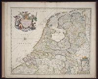
- Creator:
- Visscher, Nicolaes, 1649-1702
- Published / Created:
- ca. 1684
- Call Number:
- Folio 469
- Collection Title:
- [Atlas factice of 13 maps by Nicolaes Visscher I, Nicolaes Visscher II, Guillaume Sanson, and
- Image Count:
- 1
- Publisher:
- Nicolaes Visscher
- Subject (Geographic):
- Benelux countries --Maps --Early works to 1800 and Europe --Maps --Early works to 1800
- Subject (Topic):
- Atlases, Dutch --Early works to 1800
- Collection Created:
- 1677-1692
- Found in:
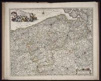
- Beinecke Rare Book and Manuscript Library > Belgium Foederatum / [cartographic material] / emendate auctum et novissime editum, per Nicolaum Visscher
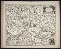
- Creator:
- Visscher, Nicolaes, 1649-1702
- Published / Created:
- ca. 1684
- Call Number:
- Folio 469
- Collection Title:
- [Atlas factice of 13 maps by Nicolaes Visscher I, Nicolaes Visscher II, Guillaume Sanson, and
- Image Count:
- 1
- Publisher:
- Nicolaes Visscher
- Subject (Geographic):
- Europe --Maps --Early works to 1800 and Hainaut (Belgium) --Maps --Early works to 1800
- Subject (Topic):
- Atlases, Dutch --Early works to 1800
- Collection Created:
- 1677-1692
- Found in:
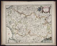
- Beinecke Rare Book and Manuscript Library > Comitatus Hannoniae et Archiepiscopatus Cameracensis tabula / [cartographic material] / per Nicolaum Visscher
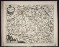
- Creator:
- Visscher, Nicolaes, 1649-1702
- Published / Created:
- ca. 1684
- Call Number:
- Folio 469
- Collection Title:
- [Atlas factice of 13 maps by Nicolaes Visscher I, Nicolaes Visscher II, Guillaume Sanson, and
- Image Count:
- 1
- Publisher:
- Nicolaes Visscher
- Subject (Geographic):
- Europe --Maps --Early works to 1800 and Namur (County) --Maps --Early works to 1800
- Subject (Topic):
- Atlases, Dutch --Early works to 1800
- Collection Created:
- 1677-1692
- Found in:
- Beinecke Rare Book and Manuscript Library > Comitatus Namurci / [cartographic material] / emendata delineatio nuperrime in lucem edita per Nicolaum Visscher
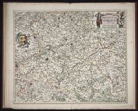
- Creator:
- Visscher, Nicolaes, 1649-1702
- Published / Created:
- ca. 1684
- Call Number:
- Folio 469
- Collection Title:
- [Atlas factice of 13 maps by Nicolaes Visscher I, Nicolaes Visscher II, Guillaume Sanson, and
- Image Count:
- 2
- Publisher:
- Nicolaes Visscher
- Subject (Geographic):
- Europe --Maps --Early works to 1800 and Luxembourg --Maps --Early works to 1800
- Subject (Topic):
- Atlases, Dutch --Early works to 1800
- Collection Created:
- 1677-1692
- Found in:
- Beinecke Rare Book and Manuscript Library > Ducatus Lutzenburgi novissima et accuratissima delineatio / [cartographic material] / per Nic. Visscher
- Creator:
- Visscher, Nicolaes, 1649-1702
- Published / Created:
- ca. 1684
- Call Number:
- Folio 469
- Collection Title:
- [Atlas factice of 13 maps by Nicolaes Visscher I, Nicolaes Visscher II, Guillaume Sanson, and
- Image Count:
- 1
- Publisher:
- Nicolaes Visscher
- Subject (Geographic):
- Belgium --Maps --Early works to 1800, Europe --Maps --Early works to 1800, and France, Northern --Maps --Early works to 1800
- Subject (Topic):
- Atlases, Dutch --Early works to 1800
- Collection Created:
- 1677-1692
- Found in:
- Beinecke Rare Book and Manuscript Library > Flandriae comitatus / [cartographic material] / accuratissima descriptio edita per Nicolaum Visscher
- Creator:
- Visscher, Nicolaes, 1649-1702
- Published / Created:
- ca. 1684
- Call Number:
- Folio 469
- Collection Title:
- [Atlas factice of 13 maps by Nicolaes Visscher I, Nicolaes Visscher II, Guillaume Sanson, and
- Image Count:
- 1
- Publisher:
- Nicolaes Visscher
- Subject (Geographic):
- Artois (France) --Maps --Early works to 1800, Europe --Maps --Early works to 1800, and Pas-de-Calais (France) --Maps --Early works to 1800
- Subject (Topic):
- Atlases, Dutch --Early works to 1800
- Found in:
- Beinecke Rare Book and Manuscript Library > Geographica Artesiae comitatus tabula / [cartographic material] / per Nicolaum Visscher edita
- Creator:
- Homann, Johann Baptist, 1663-1724
Visscher, Nicolaes, 1649-1702
- Published / Created:
- 1715?
- Call Number:
- 1975 Folio 31
- Collection Title:
- [Atlas factice of 42 maps, produced by the Homann Erben firm]
- Image Count:
- 1
- Publisher:
- Johann Baptist Homann
- Subject (Geographic):
- Ireland --Maps --Early works to 1800
- Subject (Topic):
- Atlases, German --Early works to 1800
- Collection Created:
- [Nuremberg,
- Found in:
- Beinecke Rare Book and Manuscript Library > Hiberniae regnum tam in praecipuas Ultoniae, Connaciae, Laceniae et Momoniae [cartographic material] : quam in minores earundem provincias et ditiones divisum ex prototype Guil. Petty-Vischeriano deductu et exhibitum / a Joh. Bapt. Homanno
- Creator:
- Homann, Johann Baptist, 1663-1724
Visscher, Nicolaes, 1649-1702
- Published / Created:
- 1715?
- Call Number:
- 1975 Folio 31
- Collection Title:
- [Atlas factice of 42 maps, produced by the Homann Erben firm]
- Image Count:
- 1
- Publisher:
- Johann Baptist Homann
- Subject (Geographic):
- Great Britain --Maps --Early works to 1800
- Subject (Topic):
- Atlases, German --Early works to 1800
- Collection Created:
- [Nuremberg,
- Found in:
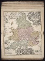
- Beinecke Rare Book and Manuscript Library > Magnae Britanniae pars meridionalis in qua regnum Angliae tam in septem antiqua Anglo-Saxonum regna quom in omnes Hodiernas regiones accurate divisum hic ostenditur quam tabula ab archetypo Vischeriano desumptam exhibet / [cartographic material] / Ioh. Ba
- Creator:
- Homann, Johann Baptist, 1663-1724
Visscher, Nicolaes, 1649-1702
- Published / Created:
- [172-?]
- Call Number:
- 1983 Folio 23
- Collection Title:
- [Atlas factice of 50 maps, primarily by Johann Baptist Homann and/or issued by the Homann Erben
- Image Count:
- 1
- Publisher:
- [Johann Baptist Homann]
- Subject (Geographic):
- Great Britain --Maps --Early works to 1800
- Collection Created:
- [Nuremberg : Homann Erben, 1710-1786]
- Found in:
- Beinecke Rare Book and Manuscript Library > Magnae Britanniae pars meridionalis in qua regnum Angliae tam in septem antiqua Anglo-Saxonum regna quom in omnes Hodiernas regiones accurate divisum hic ostenditur quam tabula ab archetypo Vischeriano desumptam exhibet [cartographic material] / Ioh. Bapt
- Creator:
- Homann, Johann Baptist, 1663-1724
Visscher, Nicolaes, 1649-1702
- Published / Created:
- 1715?
- Call Number:
- 1975 Folio 31
- Collection Title:
- [Atlas factice of 42 maps, produced by the Homann Erben firm]
- Image Count:
- 1
- Publisher:
- Johann Baptist Homann
- Subject (Geographic):
- Scotland --Maps --Early works to 1800
- Subject (Topic):
- Atlases, German --Early works to 1800
- Collection Created:
- [Nuremberg,
- Found in:
- Beinecke Rare Book and Manuscript Library > Magnae Britanniae pars septentrionalis qua regnum Scotiae [cartographic material] : in suas partes et subjacentes insulas divisum : accurata tabula ex archetypo Vischeriano desumta exhibetur imitatore / Johan. Bapt. Homanno