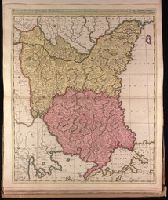
Britannia prout divisa fuit temporibus Anglo-Saxonum praesertim durante illorum heptarchia.
Description:
Border illustrations include seven Anglo-Saxon kings on the left; the conversion to Christianity of a further seven are depicted on the right., Manuscript number in upper left corner: 7., Relief shown pictorially., and Shows kingdom boundaries, rivers, settlements and shields.
Appeared in Valk and Schenk's Atlantis sylloge compendiosa, ca. 1702., Backed with paper. Ms. no. "82" in upper left corner. Sheet measures 62.5 x 53.7 cm. No. 76 of 87 maps bound together., Bar scales given in "milliaria Hungarica" and "milliaria Germanica.", Prime meridian: Ferro., and Relief shown pictorially.
Publisher:
Gerard Valk,
Subject (Geographic):
Bulgaria--Maps--Early works to 1800., Romania--Maps--Early works to 1800., and Turkey--Maps--Early works to 1800.
Subject (Name):
Schenk, Peter, 1660-1718 or 1719. Atlantis sylloge compendiosa. and Valck, G. (Gerard), 1651 or 1652-1726. Atlantis sylloge compendiosa.
Society for the Diffusion of Useful Knowledge (Great Britain)
Published / Created:
Novr. 1842.
Call Number:
BrSides Folio 2019 94
Image Count:
1
Resource Type:
Maps, Atlases & Globes
Description:
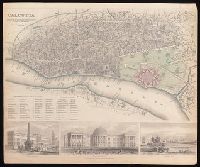
Coordinates not present on map and are approximated., Includes "References to the public buildings, churches & chapels" and illustrations of Writers Buildings, Government House and Esplanade Row., and Oriented with north to lower left.
"Avec Privilege du Roi.", Insets: Map of territory west of Lake Superior; map of territory west of Florida; view of "Sault du Niagara, de 135 pieds de haut"., Relief shown pictorially., and Second state: contains two keys to colors "Couleur selon les pretentions des Anglois" and "Selon les pretentions de la France."
Publisher:
[Georges-Louis Le Rouge] Rue des Augustins,
Subject (Geographic):
Atlantic States--Maps--Early works to 1800., France--Colonies--America--Maps--Early works to 1800., Great Britain--Colonies--America--Maps--Early works to 1800., Maritime Provinces--Maps--Early works to 1800., and United States--History--French and Indian War, 1754-1763--Maps--Early works to 1800.
"Avec privilege du Roy.", "Se vend a Bruxelles chez Eugene Henry Fricx, imprimeur du Roy.", Includes "Avertissement.", Prime meridian: Ferro., Relief shown pictorially., and Shows east coast of Brazil.
"P. II. 44" in upper right corner., From P. Santini's Atlas universel, 1784., Prime meridians: Paris; Ferro. Coordinates converted by cataloger to express longitude as measured from the Greenwich meridian., Relief shown pictorially., and This edition was issued in Venice for Francesco Santini and Giuseppi Antonio Remondini's reissue of De L'Isle's Atlas universel.
Subject (Geographic):
Bering Strait Region--Discovery and exploration--Russian--Maps--Early works to 1800., North America--Discovery and exploration--Russian--Maps--Early works to 1800., Pacific Coast (North America)--Discovery and exploration--Maps--Early works to 1800., and Russian Far East (Russia)--Discovery and exploration--Russian--Maps--Early works to 1800.
Subject (Name):
L'Isle, Guillaume de, 1675-1726., Remondini, Giuseppi Antonio, 1747-1811, publisher., and Santini, P. Atlas universel.