[Atlas factice of 42 maps, produced by the Homann Erben firm]
Image Count:
1
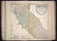
Alternative Title:
Etats de l’Eglise & du Grand Duche de Toscane, Etats de l’Eglise & du Grand Dvche de Toscane, and Status Ecclesiastici nec non Magni Ducatus Toscanae nova tabula geographica
Publisher:
Curantibus Homannianis Heredibus
Subject (Geographic):
Papal States --Maps --Early works to 1800 and Tuscany (Italy) --Maps --Early works to 1800
[Atlas factice of 50 maps, primarily by Johann Baptist Homann and/or issued by the Homann Erben
Image Count:
1
Alternative Title:
Etats de l’Eglise & du Grand Duche de Toscane, Etats de l’Eglise & du Grand Dvche de Toscane, and Status Ecclesiastici nec non Magni Ducatus Toscanae nova tabula geographica
Publisher:
Curantibus Homannianis Heredibus
Subject (Geographic):
Papal States --Maps --Early works to 1800 and Tuscany (Italy) --Maps --Early works to 1800
Appears in: Städt-atlas oder Schäuplatz berühmter Städte: Vestungen, Prospekte, Gegenden, Grundrisse, Belagergungen, etc. Nürnberg : Homännischen Erben, 1762., Insets: Landau; Strasburg; Neu Breisach; Fort Louis; Hünningen; Manheim; Philippsburg; Alt Breisach; Freiburg., Manuscript number in lower right corner: 40. From the Karpinski-von Wieser Map Collection., and Relief shown pictorially.
Publisher:
[Homann Erben]
Subject (Geographic):
Baden-Württemberg (Germany)--Maps--Early works to 1800.
Subject (Topic):
Polish Succession, War of, 1733-1738--Maps--Early works to 1800.
[Atlas factice of 50 maps, primarily by Johann Baptist Homann and/or issued by the Homann Erben
Image Count:
1
Alternative Title:
Cours de Danube
Publisher:
Cura Homannianorum Heredum, C.P.S.C.M
Subject (Geographic):
Balkan Peninsula --Maps --Early works to 1800, Danube River Valley --Maps --Early works to 1800, Europe, Central --Maps --Early works to 1800, and Europe, Southern --Maps --Early works to 1800
Carte de la Turquie Asiatique contenant la Natolie Moderne divisée en fes Beglerbeys &.
Description:
"C.P.S.C.M.", Bar scales given in "milliaria Germanica," "milliaria Turcica terrestria," and "milliaria Turcica marina"., Imperfect: chewed at edges, witn some loss of text. Sheet measures 48.6 x 54.7 cm., Prime meridian: Ferro., Relief shown pictorially., and Wat
Publisher:
Impensis Homannianorum Heredum,
Subject (Geographic):
Middle East--Maps--Early works to 1800 and Turkey--Maps--Early works to 1800