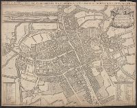
Nova & accuratissima celeberrimæ universitatis civitatisque Oxoniensis scenographia
Description:
"Cum privil. S.R.M. 1675"., Copy 1: Sheet measures 42 x 54 cm. Verso: Stamped "Bibliotheca Bodleiana", "Madan Collection"., Dedication to Henry Compton., From Loggan's Oxonia illustrata ... [Oxford : The Sheldonian Theatre, 1675]., and Index of academic and civic
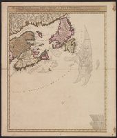
Carte nouvelle contenant la partie d'Amerique la plus septentrionale : ou sont exactement dêcrites les provinces suivantes comme le Canada ou Nouvelle France, la Nouvelle Ecosse, la Nouvelle Angleterre, les Nouveaux Paı̈s Bas, la Pensylvanie, la Virginie
Description:
"Cum privilegio ordinum generalium foederati Belgii.", Appears in some eds. of the author's Atlas minor sive geographia compendiosa., Library copy incomplete, Atlantic Canada sheet only; damaged in upper left., and Relief shown pictorially. Depths shown by sound
Publisher:
Nicolao Visscher,
Subject (Geographic):
Atlantic Provinces--Maps--Early works to 1800 and North America--Maps--Early works to 1800
Subject (Name):
Anse, Luggert van, fl. 1690-1716, engraver and Visscher, Nicolaes, 1649-1702. Atlas minor sive geographia compendiosa
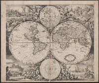
Imperfect: mutilated along folds, with some loss of text. Cross collection no. 24., Includes ill. and ancillary maps of north and south polar regions., and Relief shown pictorially.
Homann Erben (Firm) Homann, Johann Baptist, 1663-1724 Meyer, Tobias
Published / Created:
1749
Call Number:
1973 Folio 30
Collection Title:
[Atlas factice of 32 maps and 1 distance table, produced by the Homann Erben firm]
Image Count:
1
Alternative Title:
General map of Great Britain and Ireland with part of Holland Flandres France &c. agreable to modern history by the heirs of late Mr. Homann at Nueremburg 1749, priviledged by Emperours Majesty
Publisher:
Edentibg. Homan[n]ianis heredibus
Subject (Geographic):
Great Britain --Maps --Early works to 1800 and Ireland --Maps --Early works to 1800
Descriptio ac delineatio geographica detectionis freti, sive, transitus ad occasum supra terras
Image Count:
1
Abstract:
Map depicts the Coat of Arms of the United Kingdom (era of the Union of the Crowns), reigning between the years 1603-1707.
Alternative Title:
Tabula nautica, qua repraesentantur orae maritimae, meatus, ac freta, noviter a H. Hudsono Anglo ad Caurum supra Novam Franciam
Description:
Bound in after p. [2]., In pencil on recto: 170., Map cut and folded irregularly., Map has multiple small stains on both the recto and verso., and Scale [ca. 1:9,000,000].
Descriptio ac delineatio geographica detectionis freti, sive, transitus ad occasum supra terras
Image Count:
1
Abstract:
Map depicts the Coat of Arms of the United Kingdom (era of the Union of the Crowns), reigning between the years 1603-1707.
Alternative Title:
Tabula nautica ...
Description:
Bound in after p. [6]., In ink on recto: place names "Okkak", "Nain"[?] and one longer handwritten note on the bottom margin., Map cut and folded irregularly., Map has been repaired with multiple pieces of tape on verso., Map has multiple small stains on both the recto and verso., Printed on recto in lower right corner: A1., and Scale [ca. 1:9,000,000].
Subject (Geographic):
North Atlantic Ocean --Maps --Early works to 1800
Subject (Name):
Hudson, Henry, d. 1611
Collection Created:
Amsterodami Ex officina Hesse lij Gerardi. Anno 1613
Charts and title pages in English, text in Dutch., Map oriented with North at bottom left., and Volvelle on p. [17].
Publisher:
Jodocus Hondius excudit,
Subject (Geographic):
Europe --Maps --Early works to 1800, Great Britain --Maps --Early works to 1800, Netherlands --Maps --Early works to 1800, and North Sea --Maps --Early works to 1800
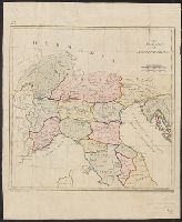
In top left margin: 24., Prime meridians: London and Ferro., Relief shown pictorially., Title in English, place names in Latin., and Watermarks: J. Buttanshaw; coat of arms over G.R.
Publisher:
T. Stackhouse,
Subject (Geographic):
Italy--Historical geography--Maps--Early works to 1800, Italy--History--To 476--Maps--Early works to 1800, and Rome--Maps--Early works to 1800