National Geographic Society (U.S.). Cartographic Division
Published / Created:
1986
Call Number:
8101 1986
Container / Volume:
BRBL_00552
Image Count:
2
Resource Type:
Maps, Atlases & Globes
Alternative Title:
Making of America ; no. 13
Description:
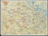
"Supplement to the National Geographic, December 1986, page 786A, vol. 170, no. 6.", Includes historical notes and key to abbreviations., Panel title: The making of America, Northern Plains., Relief shown by shading and spot heights., and Text, col. ill., and 5 m
Publisher:
The Society,
Subject (Geographic):
Great Plains--History--Maps, Great Plains--Maps, Middle West--History--Maps, and Middle West--Maps
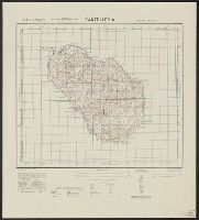
National Geographic Society (U.S.). Cartographic Division
Published / Created:
1960
Call Number:
845 1960
Container / Volume:
BRBL_00620
Image Count:
1
Resource Type:
Maps, Atlases & Globes
Description:
"Atlas plate 11.", Relief shown by shading and spot heights. Depths shown by gradient tints and soundings., and Supplement to April, 1960 issue of the National Geographic magazine.
National Geographic Society (U.S.). Cartographic Section
Published / Created:
1950
Call Number:
845 1950
Container / Volume:
BRBL_00620
Image Count:
1
Resource Type:
Maps, Atlases & Globes
Description:
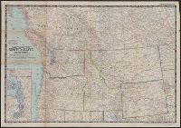
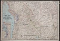
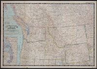
"Compilation by H.C. Bryan, R.W. Collins, R.J. Daily, A.D. Grozzini, and A.E. Holdstock. Relief by John J. Brehm.", Inset map: Puget Sound Region, scale 1:1,000,000 or 15.8 miles to the inch., and Issued as supplement to National Geographic, v.97, no. 6, June 1950.
National Geographic Society (U.S.). Cartographic Section
Published / Created:
1950
Call Number:
80 1950
Container / Volume:
BRBL_00536
Image Count:
1
Resource Type:
Maps, Atlases & Globes
Description:
"Compilation by H.C. Bryan, R.W. Collins, R.J. Darley, A.D. Grazzini, and A.E. Holdstock. Relief by John J. Brehm.", Inset: Puget Sound Region. Scale 1:1,000,000 or 15.8 miles to the in., Issued as supplement to National Geographic, v.97, no. 6, June 1950., and Relief shown by shading and spot heights.
Publisher:
The Society,
Subject (Geographic):
Alberta--Maps, British Columbia--Maps, Northwest, Pacific--Maps, and Saskatchewan--Maps
Subject (Name):
Brehm, J. J, Bryan, H. C, Collins, R. W, Darley, James M. (James Morrison), Darley, Richard J, Grazzini, Athos D, and Holdstock, A. E
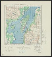
Great Britain. War Office. General Staff. Geographical Section
Published / Created:
1942,
Call Number:
344 T75 1943
Container / Volume:
BRBL_00094
Image Count:
1
Resource Type:
Maps, Atlases & Globes
Alternative Title:
Geographical Section, General Staff ; No. 4246, GSGS (Series) ; 4246., and Tromsö omegn
Description:
"Contour interval 30 metres.", "Reproduced from Norwegian map of 1932 by O.S., 1942.", "War Office, 1942.", Includes notes and diagrams., Military grid., and Relief shown by contours and spot heights.
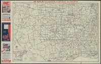
Official road map, western states and Western states
Description:
"This map revised annually, next issue spring 1941.", In lower left: 4004-J., Includes ill. and text., Index, text, and advertisements on verso., and Relief shown by spot heights and pictorially.
Map of south central states and South central states
Description:
Advertisement, index, text, and map of "Mexican highways" (scale [ca. 1:5,258,880]) on verso., Includes advertisements and inset of routes between San Antonio, Houston, Laredo, and Brownsville., and Relief shown by hachures and spot heights.
Publisher:
AAA,
Subject (Topic):
Roads--Mexico--Maps and Roads--Southern states--Maps
Great Britain. War Office. General Staff. Geographical Section
Published / Created:
1943
Call Number:
40 P19 1942
Container / Volume:
BRBL_00213
Image Count:
1
Resource Type:
Maps, Atlases & Globes
Alternative Title:
Geographical Section, General Staff ; no. 4162 and GSGS (Series) ; 4162.
Description:
"3-43.", "Copied from an Italian map of 1896.", "Grid added November 1942.", Military grid., and Relief shown by contours, rock drawings, and spot heights.