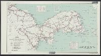
United States. Office of Strategic Services. Research and Analysis Branch
Published / Created:
1945
Call Number:
574gm 1945BA
Container / Volume:
BRBL_00311
Image Count:
1
Resource Type:
Maps, Atlases & Globes
Alternative Title:
Korea roads and railroads
Description:
"No. 6171 ... 28 February 1945.", Includes glossary with Korean, Japanese, English and Chinese terms., Inset: Ullŭng-do., and Oriented with north to left.
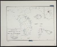
United States. Office of Strategic Services. Research and Analysis Branch
Published / Created:
1945
Call Number:
56gm 1945C
Container / Volume:
BRBL_00298
Image Count:
1
Resource Type:
Maps, Atlases & Globes
Description:
"No. 3294.", Includes reliability diagram., Inset maps: Routes to northwest China through Russia and India. -- [Area map]., and Relief shown by spot heights.
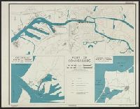
United States. Office of Strategic Services. Research and Analysis Branch
Published / Created:
[1944]
Call Number:
36 K54 1944
Container / Volume:
BRBL_00124
Image Count:
2
Resource Type:
Maps, Atlases & Globes
Description:
"9 November 1944.", "Base: C.B. no. 1818, plan no. 16, June 1940. Port area corrected from aerial photographs taken July 1944.", "No. 5294 - R&A, OSS.", 36 K54 1944: Stamp in upper rig, Includes index map., and Index to numbered basins & shipyards on verso.
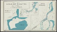
United States. Office of Strategic Services. Research and Analysis Branch
Published / Created:
1944
Call Number:
352 K125 1944
Container / Volume:
BRBL_00107
Image Count:
2
Resource Type:
Maps, Atlases & Globes
Description:
"Index to numbered basins and quays" on verso., "No. 5413"., Ancillary maps: Port of Pillau -- Königsberg and Pillau., and Ms. annotation: Restricted.
Publisher:
Reproduction Branch, OSS,
Subject (Geographic):
Baltiĭsk (Russia)--Maps and Kaliningrad (Kaliningradskai︠a︡ oblastʹ, Russia)--Maps
Subject (Topic):
Harbors--Russia (Federation)--Baltiĭsk--Maps and Harbors--Russia (Federation)--Kaliningrad (Kaliningradskai︠a︡ oblastʹ)--Maps