Skip to search
Skip to main content
Skip to first result
Search
You Searched For
Genre
Maps
Publication Place
[Washington, D.C.] :
New Search
Search Results
Creator:
Published / Created:
1945
Call Number:
36fb 1945B
Container / Volume:
BRBL_00128
Image Count:
1
Resource Type:
Maps, Atlases & Globes
Description:
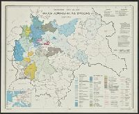
"No. 3817 - R & A, OSS, rev. 1 May, 1945." and Includes 2 insets.
Publisher:
R & A, OSS,
Subject (Geographic):
Europe, Central--Administrative and political divisions--Maps and Germany--Administrative and political divisions--Maps
Found in:
Beinecke Rare Book and Manuscript Library > Greater Germany, administrative divisions, 1 July 1944.
Creator:
Published / Created:
1945
Call Number:
36fb 1945
Container / Volume:
BRBL_00128
Image Count:
1
Resource Type:
Maps, Atlases & Globes
Description:
"FREE"--Upper right border and center lower border., "No. 5408 -- R & A, OSS, rev. 1 May, 1945.", Includes location map, "Reliability of data" table, and notes., and Indexed for administrative units.
Publisher:
R & A, OSS,
Subject (Geographic):
Europe, Central--Administrative and political divisions--Maps and Germany--Administrative and political divisions--Maps
Subject (Name):
United States. Office of Strategic Services. Reproduction Branch
Found in:
Beinecke Rare Book and Manuscript Library > Greater Germany, major administrative divisions, 1 July, 1944 / lithographed in the Reproduction Branch, OSS.
Published / Created:
[1843]
Call Number:
807 1843
Container / Volume:
BRBL_00731
Image Count:
2
Resource Type:
Maps, Atlases & Globes
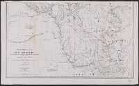
Description:
"Published by order of the U.S. House of Representatives."
Publisher:
C.B. Graham's lithy.,
Subject (Geographic):
Mississippi River--Maps
Found in:
Beinecke Rare Book and Manuscript Library > Hydrographical basin of the upper Mississippi River ... / by J.N. Nicollet ...
Creator:
Published / Created:
1879
Call Number:
826 1879
Container / Volume:
BRBL_00577
Image Count:
1
Resource Type:
Maps, Atlases & Globes
Description:
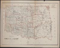
Includes dates of treaties with Indian nations., Library's copy annotated in black ink., Prime meridians: Washington and Greenwich., Relief shown by hachures., and Shows wagon roads, trails, railroads and natural features.
Publisher:
General Land Office,
Subject (Geographic):
Indian Territory--Maps
Subject (Name):
Roeser, C. (Charles)
Found in:
Beinecke Rare Book and Manuscript Library > Indian Territory, 1879 / compiled from the official records of the General Land Office and other sources by C. Roeser, Principal Draughtsman.
Creator:
Published / Created:
1945
Call Number:
581gfc 1945
Container / Volume:
BRBL_00314
Image Count:
1
Resource Type:
Maps, Atlases & Globes
Description:
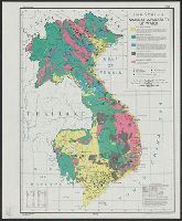
"8 Oct. 1945.", "No. 8124.", and Includes glossary and "Reliability of data" table.
Publisher:
lithographed in the Reproduction Branch, SSU,
Subject (Name):
United States. War Dept. Strategic Services Unit. Reproduction Branch
Subject (Topic):
Industries--Indochina--Maps and Mineral industries--Indochina--Maps
Found in:
Beinecke Rare Book and Manuscript Library > Indochina, construction materials / R & A, IRIS.
Creator:
Published / Created:
[1945]
Call Number:
581gfa 1945
Container / Volume:
BRBL_00314
Image Count:
1
Resource Type:
Maps, Atlases & Globes
Description:
"8 October, 1945.", "No. 8151.", and Includes "Glossary" and table of "Reliability of data."
Publisher:
lithographed in the Reproduction Branch, OSS,
Subject (Name):
United States. Office of Strategic Services. Reproduction Branch
Subject (Topic):
Water-supply--Indochina--Maps
Found in:
Beinecke Rare Book and Manuscript Library > Indochina, natural availability of water / R & A, IRIS.
Creator:
Published / Created:
1915
Call Number:
75gce 1915
Container / Volume:
BRBL_00410
Image Count:
1
Resource Type:
Maps, Atlases & Globes
Alternative Title:
Outline map of the United States by counties
Description:
"Jan. 1, 1915" in lower left margin., Irrigated areas shown on outline map of the United States. Explanation in margin., and This edition has county names printed in blue.
Publisher:
Office of Farm Management,
Subject (Geographic):
United States--Administrative and political divisions--Maps and United States--Maps
Subject (Name):
Geological Survey (U.S.)
Subject (Topic):
Irrigation--United States--Maps
Found in:
Beinecke Rare Book and Manuscript Library > Irrigation map of the United States / engraved and printed by the U.S. Geological Survey ; outline of irrigated areas based upon data collected by the Bureau of the Census, 1910 ; revised by Irrigation Division, Office of Experimental Stations, and by the
Creator:
Published / Created:
1945
Call Number:
57gfa 1945
Container / Volume:
BRBL_00305
Image Count:
1
Resource Type:
Maps, Atlases & Globes
Description:
"15 January 1945.", "No. 5572-R&A, O.S.S.", Includes glossary and table: Reliability of data., and Inset: Hokkaidō.
Publisher:
OSS,
Subject (Geographic):
Japan--Maps
Subject (Topic):
Waterworks--Japan--Maps
Found in:
Beinecke Rare Book and Manuscript Library > Japan : distribution of waterworks.
Creator:
Published / Created:
1945
Call Number:
57gp 1945
Container / Volume:
BRBL_00307
Image Count:
1
Resource Type:
Maps, Atlases & Globes
Description:
"1 September 1945.", "No. 6172 -- R & A, OSS.", Indicates gross tonnage and proportion of sailing vessels., and Inset: Japan secondary ports.
Publisher:
Reproduction Branch, OSS,
Subject (Geographic):
Japan--Maps
Subject (Name):
United States. Office of Strategic Services. Reproduction Branch
Subject (Topic):
Shipping--Japan--Maps
Found in:
Beinecke Rare Book and Manuscript Library > Japan : ports of greatest shipping activity (entrances and clearances of vessels in gross tons) 1934.
Creator:
Published / Created:
1945
Call Number:
57 1945C
Container / Volume:
BRBL_00303
Image Count:
1
Resource Type:
Maps, Atlases & Globes
Description:
"31 October 1945.", "No. 5930 - R&A, IRIS.", Includes glossary and reliability table., Inset: Hokkaidō., and Relief indicated by shading.
Publisher:
IRIS,
Subject (Geographic):
Japan--Maps
Found in:
Beinecke Rare Book and Manuscript Library > Japan cities and towns : (shi and machi).
Branch:v1.61.8 ,Deployed:2024-06-20T11:14:55-04:00