
You Searched For
1 - 9 of 9
Search Results
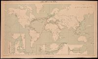
- Creator:
- Great Britain. War Office. General Staff. Geographical Section
- Published / Created:
- 1909
- Call Number:
- BrSides Double Folio 2018 95
- Image Count:
- 1
- Resource Type:
- Maps, Atlases & Globes
- Alternative Title:
- G.S.G.S. ; No. 1849 and GSGS (Series) ; No. 1849
- Description:
- Backed with linen. and Includes grid, notes and 6 inset maps.
- Publisher:
- War Office,
- Subject (Topic):
- Cables, Submarine--Maps., Telegraph, Telegraph--Maps., and World maps
- Found in:
- Beinecke Rare Book and Manuscript Library > Cable map of the world [cartographic material].
3.
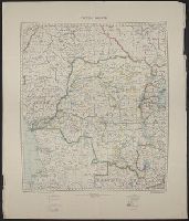
- Creator:
- Great Britain. War Office. General Staff. Geographical Section
- Published / Created:
- 1921
- Call Number:
- 652 1921
- Container / Volume:
- BRBL_00342
- Image Count:
- 1
- Resource Type:
- Maps, Atlases & Globes
- Description:
- Information on map as of 1918., Relief shown by gradient tints., and Sheet measures 74 x 65 cm.
- Publisher:
- Geographical Section, General Staff,
- Subject (Geographic):
- Congo (Democratic Republic)--Maps
- Found in:
- Beinecke Rare Book and Manuscript Library > Congo Belge.
4.

- Creator:
- Great Britain. War Office. General Staff. Geographical Section
- Published / Created:
- 1921
- Call Number:
- 652 1921
- Container / Volume:
- BRBL_00342
- Image Count:
- 1
- Resource Type:
- Maps, Atlases & Globes
- Description:
- Information on map as of 1918., Relief shown by gradient tints., and Sheet measures 74 x 65 cm.
- Publisher:
- Geographical Section, General Staff,
- Subject (Geographic):
- Congo (Democratic Republic)--Maps
- Found in:
- Beinecke Rare Book and Manuscript Library > Congo Belge.

- Creator:
- Great Britain. War Office. General Staff. Geographical Section
- Published / Created:
- [1918?]
- Call Number:
- 36 K54 1918
- Container / Volume:
- BRBL_00124
- Image Count:
- 1
- Resource Type:
- Maps, Atlases & Globes
- Alternative Title:
- Helgoland und Düne, Sketch map showing southern portion of Jutland Peninsula and Heligoland., and The Kaiser Wilhelm Canal.
- Description:
- "Dec. 1918"--In lower right corner of margin., The Kaiser Wilhelm Canal -- Helgoland und Düne -- Sketch map showing southern portion of Jutland Peninsula & Heligoland., and Title from top margin.
- Publisher:
- War Office,
- Subject (Geographic):
- Helgoland (Germany)--Maps, Kiel Canal (Germany)--Maps, and Schleswig-Holstein (Germany)--Maps
- Found in:
- Beinecke Rare Book and Manuscript Library > Kiel Canal and Heligoland.

- Creator:
- Great Britain. War Office. General Staff. Geographical Section
- Published / Created:
- 1945
- Call Number:
- 5855 1945
- Container / Volume:
- BRBL_00315
- Image Count:
- 1
- Resource Type:
- Maps, Atlases & Globes
- Alternative Title:
- G.S.G.S. ; no. 4474, GSGS (Series) ; no. 4474., and Kota Bharu
- Description:
- "Copied from a map prepared by Survey Department F.M.S., dated 1937. Revised, and roads reclassified by I.S.T.D., 1945. Photolithographed by the War Office, 1945." and Stamped "AMS 1 324197".
- Publisher:
- War Office,
- Subject (Geographic):
- Malaya--Maps
- Found in:
- Beinecke Rare Book and Manuscript Library > Malaya 1:380,160 : Kota Bharu Sheet No.2.

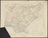
- Creator:
- Great Britain. War Office. General Staff. Geographical Section
- Published / Created:
- 1905
- Call Number:
- 4894 1905A
- Container / Volume:
- BRBL_00267
- Image Count:
- 1
- Resource Type:
- Maps, Atlases & Globes
- Alternative Title:
- Geographical Section, General Staff ; no. 1896 and GSGS (Series) ; 1896.
- Description:
- "Additions August 1905." and Relief shown by shading and spot heights.
- Publisher:
- War Office,
- Subject (Geographic):
- Crete (Greece)--Maps
- Found in:
- Beinecke Rare Book and Manuscript Library > Map of Crete [cartographic material].
- Creator:
- Great Britain. War Office. General Staff. Geographical Section
- Published / Created:
- 1910
- Call Number:
- 6551 1910
- Container / Volume:
- BRBL_00346
- Image Count:
- 1
- Resource Type:
- Maps, Atlases & Globes
- Alternative Title:
- G.S., G.S. ; no. 2437. and GSGS (Series) ; 2437.
- Description:
- Imperfect: Chewed. Accompanying text (47 p.) wanting.
- Publisher:
- War Office,
- Subject (Geographic):
- Nigeria--Maps
- Found in:
- Beinecke Rare Book and Manuscript Library > Northern and southern Nigeria / Comp. in the Geog. Section, Gen. Staff.
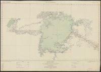
- Creator:
- Great Britain. War Office. General Staff. Geographical Section
- Published / Created:
- 1919
- Call Number:
- 399 1919
- Container / Volume:
- BRBL_00195
- Image Count:
- 1
- Resource Type:
- Maps, Atlases & Globes
- Alternative Title:
- Geographical Section, General Staff ; no. 2920 and GSGS (Series) ; 2920.
- Description:
- Relief shown by contours and spot heights; depths by soundings and isolines.
- Publisher:
- War Office,
- Subject (Geographic):
- Gibraltar, Strait of--Maps
- Found in:
- Beinecke Rare Book and Manuscript Library > Straits of Gibraltar [cartographic material].