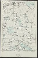
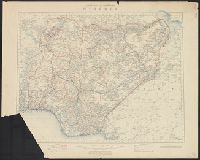
Great Britain. War Office. General Staff. Geographical Section United States. Army Map Service
Published / Created:
1942
Call Number:
352gme M94 1942C
Container / Volume:
BRBL_00111
Image Count:
1
Resource Type:
Maps, Atlases & Globes
Alternative Title:
Geographical Section, General Staff ; no. 4224 and GSGS (Series) ; no. 4224.
Description:
Five classes of roads and paths are also indicated., In lower left corner of margin: War Office 1941., and In lower right corner of margin: Reproduced from a Finnish map.
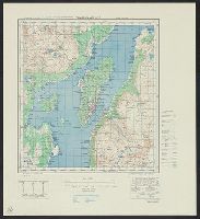
Great Britain. War Office. General Staff. Geographical Section United States. Army Map Service
Published / Created:
1942
Call Number:
352gme M94 1942D
Container / Volume:
BRBL_00111
Image Count:
1
Resource Type:
Maps, Atlases & Globes
Alternative Title:
Geographical Section, General Staff ; no. 4224 and GSGS (Series) ; no. 4224.
Description:
Five classes of roads and paths are also indicated., In lower left corner of margin: War Office 1941., and In lower right corner of margin: Reproduced from a Finnish map.
Great Britain. War Office. General Staff. Geographical Section United States. Army Map Service
Published / Created:
1942
Call Number:
352gme M94 1942E
Container / Volume:
BRBL_00111
Image Count:
1
Resource Type:
Maps, Atlases & Globes
Alternative Title:
Geographical Section, General Staff ; no. 4224 and GSGS (Series) ; no. 4224.
Description:
Five classes of roads and paths are also indicated., In lower left corner of margin: War Office 1941., and In lower right corner of margin: Reproduced from a Finnish map.
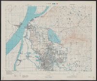
Great Britain. War Office. General Staff. Geographical Section
Published / Created:
1945
Call Number:
56 N15 1945
Container / Volume:
BRBL_00297
Image Count:
1
Resource Type:
Maps, Atlases & Globes
Alternative Title:
[U.S. Army Map Service. A.M.S. ; L901], GSGS (Series) ; 3831., Its [G.S.G.S.] ; 3831, and Series (Standard map series designation system) ; L901.
Description:
"5-45.", "Contour interval 10 metres.", At head of title: China., Four classes of roads and paths are shown; some streets and buildings are named; areas of vegetation and cultivation are shown., and Military grid.
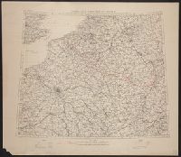
Great Britain. War Office. General Staff. Geographical Section
Published / Created:
[1918?]
Call Number:
38fd 1918
Container / Volume:
BRBL_00170
Image Count:
1
Resource Type:
Maps, Atlases & Globes
Alternative Title:
GSGS (Series) ; 3700.
Description:
"G.S.G.S. 3700.", Ordnance Survey, November 1918., Relief shown by spot heights., and Shows boundaries as in 1792, 1814, and 1815. To illustrate the post-WW1 settlement.
Publisher:
Ordnance Survey,
Subject (Geographic):
Belgium--Boundaries--France--Maps, France--Boundaries--Belgium--Maps, France--Boundaries--Germany--Maps, and Germany--Boundaries--France--Maps
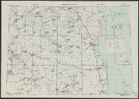
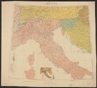
Great Britain. War Office. General Staff. Geographical Section
Published / Created:
1918
Call Number:
11hcf 1919D-6
Image Count:
1
Resource Type:
Maps, Atlases & Globes
Alternative Title:
G.S.G.S. ; 3703a and GSGS (Series) ; 3703a.
Description:
Includes graph "Population of certain towns." and index to adjoining maps in series. and Inset map: Density of population.
Publisher:
War Office [G.S.G.S.],
Subject (Geographic):
Balkan Peninsula--Maps, Europe, Central--Maps, and Italy--Maps
Subject (Topic):
Ethnology--Balkan Peninsula--Maps, Ethnology--Europe, Central--Maps, Ethnology--Italy--Maps, Population density--, Population density--Balkan Peninsula--Maps, and Population density--Europe, Central--Maps
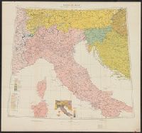
Great Britain. War Office. General Staff. Geographical Section
Published / Created:
1918
Call Number:
40ed 1918
Container / Volume:
BRBL_00229
Image Count:
1
Resource Type:
Maps, Atlases & Globes
Alternative Title:
G.S.G.S. ; 3703a and GSGS (Series) ; 3703a.
Description:
Includes graph "Population of certain towns." and index to adjoining maps in series. and Inset map: Density of population.
Publisher:
War Office [G.S.G.S.],
Subject (Geographic):
Balkan Peninsula--Maps, Europe, Central--Maps, and Italy--Maps
Subject (Topic):
Ethnology--Balkan Peninsula--Maps, Ethnology--Europe, Central--Maps, Ethnology--Italy--Maps, Population density--, Population density--Balkan Peninsula--Maps, and Population density--Europe, Central--Maps
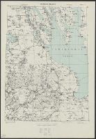
Great Britain. War Office. General Staff. Geographical Section
Published / Created:
1942,
Call Number:
344 T75 1943
Container / Volume:
BRBL_00094
Image Count:
1
Resource Type:
Maps, Atlases & Globes
Alternative Title:
Geographical Section, General Staff ; No. 4246, GSGS (Series) ; 4246., and Tromsö omegn
Description:
"Contour interval 30 metres.", "Reproduced from Norwegian map of 1932 by O.S., 1942.", "War Office, 1942.", Includes notes and diagrams., Military grid., and Relief shown by contours and spot heights.