Skip to search
Skip to main content
Skip to first result
Search
You Searched For
Genre
Maps
Creator
Geological Survey (U.S.)
New Search
Search Results
Creator:
Published / Created:
[1910]
Call Number:
844fcm Y83 1910
Container / Volume:
BRBL_00615
Image Count:
1
Resource Type:
Maps, Atlases & Globes
Description:
Relief shown by contours and spot heights. and Shows park limits established by various Acts of Congress.
Publisher:
Geological Survey,
Subject (Geographic):
Yosemite National Park (Calif.)--Administrative and political divisions--Maps and Yosemite National Park (Calif.)--Maps
Found in:
Beinecke Rare Book and Manuscript Library > Administrative map of Yosemite National Park, California / topography by R.E. Marshall and A.H. Sylvester ; surveyed in 1893-94, 1896, 1898-99 and 1905.
Creator:
Published / Created:
1906
Call Number:
771cbf Al13 1906
Image Count:
1
Resource Type:
Maps, Atlases & Globes
Description:
"Henry Gannet, Chief Geographer, H.M. Wilson, Geographer in charge; Topography by Frank Sutton and J.H. Jennings; surveyed in 1891-1892.", "Reprinted Nov. 1906.", "Surveyed in cooperation with the State of New York.", Contour interval 20 feet., and Relief shown by contours.
Publisher:
U.S. Geological Survey,
Subject (Geographic):
Albany Region (N.Y.)--Maps
Subject (Name):
Gannett, Henry, 1846-1914
Found in:
Beinecke Rare Book and Manuscript Library > Albany and vicinity, New York.
Creator:
Published / Created:
[1893]
Call Number:
831ca 1893
Container / Volume:
BRBL_00581
Image Count:
1
Resource Type:
Maps, Atlases & Globes
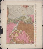
Description:
"Contour interval 200 feet."
Publisher:
Geological Survey,
Subject (Name):
Douglas, Edward Morehouse, 1855-1932, Gannett, Henry, 1846-1914, Hague, A. (Arnold), 1840-1917, Iddings, Joseph Paxson, 1857-1920, Leffingwell, W. H, Northern Transcontinental Survey, and Rensh
Subject (Topic):
Geology--Montana--Park County--Maps
Found in:
Beinecke Rare Book and Manuscript Library > Areal geology, Montana, Livingston sheet / U.S. Geological Survey, J.W. Powell, Director ; Henry Gannett, Chief Topographer ; A.H. Thompson, Geographer in charge ; triangulation by E.M. Douglas and J.H. Renshawe ; topography by Northern Transcontinental S
Creator:
Published / Created:
1917?]
Call Number:
38hc L337 1917
Container / Volume:
BRBL_00173
Image Count:
1
Resource Type:
Maps, Atlases & Globes
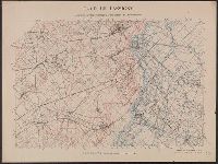
Description:
Shows "quadrille de Bonne en noir, quarillage Lambert en rouge." and WWI battle area NE of Lassigny, France.
Subject (Geographic):
Oise (France)--Maps
Subject (Topic):
World War, 1914-1918
Found in:
Beinecke Rare Book and Manuscript Library > Camp de Lassigny, Anciennes Organisations Francaises et Allemandes [cartographic material] / Engraved and printed by the U.S. Geological Survey.
Creator:
Published / Created:
1916?]
Call Number:
38hc L337 1916
Container / Volume:
BRBL_00173
Image Count:
1
Resource Type:
Maps, Atlases & Globes
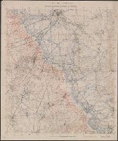
Description:
Shows "quadrille de Bonne en noir, quarillage Lambert en rouge." and WWI battle area NE of Lassigny, France.
Subject (Geographic):
Oise (France)--Maps
Subject (Topic):
World War, 1914-1918 and World War, 1914-1918--Campaigns--France
Found in:
Beinecke Rare Book and Manuscript Library > Camp de Lassigny, Anciennes Organisations Francaises et Allemandes [cartographic material].
Creator:
Published / Created:
1910
Call Number:
BrSides Double Folio 2019 84
Image Count:
1
Resource Type:
Maps, Atlases & Globes
Alternative Title:
Leadville special and Leadville special map
Description:
"Surveyed in 1879. Railroads and some shafts added later.", Relief shown by contours., and Shows mining activity.
Publisher:
U.S. Geological Survey,
Subject (Geographic):
Leadville (Colo.)--Maps.
Subject (Name):
Wilson, A. D.
Subject (Topic):
Mines and mineral resources--Colorado--Leadville--Maps.
Found in:
Beinecke Rare Book and Manuscript Library > Colorado (Lake County), Leadville special map [cartographic material] / triangulation and topography by A.D. Wilson, chief topographer.
Creator:
Published / Created:
1906
Call Number:
BrSides Folio 2019 61
Image Count:
1
Resource Type:
Maps, Atlases & Globes
Alternative Title:
Central City special map
Description:
"Surveyed in 1904.", Relief shown by contours and hachures., and Shows mining activity.
Publisher:
The Survey,
Subject (Geographic):
Central City (Colo.)--Maps. and Colorado--Central City
Subject (Name):
Chapman, Pearson, Douglas, E. M. (Edward Morehouse), 1855-1932, Moor, D. F., and Tweedy, Frank, 1854-1937
Subject (Topic):
Gold mines and mining--Colorado--Central City--Maps. and Mines and mineral resources--Colorado--Central City--Maps.
Found in:
Beinecke Rare Book and Manuscript Library > Colorado, Central City special map [cartographic material] / U.S. Geological Survey ; E.M. Douglas, geographer ; Frank Tweedy, in charge of section ; topography by Pearson Chapman and D.F. Moor ; triangulation by Frank Tweedy.
Creator:
Published / Created:
1916
Call Number:
304ed 1916
Container / Volume:
BRBL_00034A
Image Count:
1
Resource Type:
Maps, Atlases & Globes
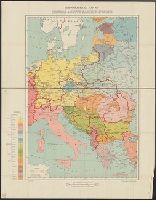
Alternative Title:
Central and South Eastern Europe.
Description:
"G.S., G.S., no. 2824."
Publisher:
Drawn and printed at the War Office,
Subject (Geographic):
Europe, Central--Maps
Found in:
Beinecke Rare Book and Manuscript Library > Ethnographical Map of Central & South Eastern Europe.
Creator:
Published / Created:
1905?]
Call Number:
837gce T764 1905
Container / Volume:
BRBL_00594
Image Count:
1
Resource Type:
Maps, Atlases & Globes
Description:
"Third annual report Reclamation Service, Pl. XXXI.", Relief shown by hachures and spot heights., and Shows irrigable lands, surveyed canal lines, and irrigation canals under construction.
Publisher:
U.S. G.P.O,
Subject (Name):
A. Hoen & Co and Geological Survey (U.S.). Reclamation Service. Annual report of the Reclamation Service
Subject (Topic):
Irrigation projects--Carson River Watershed (Nev.)--Maps, Irrigation projects--Truckee River Watershed (Calif. and Nev.)--Maps, and Irrigation--Nevada--Maps
Found in:
Beinecke Rare Book and Manuscript Library > General map of Truckee-Carson Project, Nevada / U.S. Geological Survey.
Branch:v1.61.6 ,Deployed:2024-06-12T09:55:36-04:00