Map of all the world in two hemispheres in which are exactly described all the parts of the earth and seas
Description:
Dedicated To the most serene and most sacred majesty of Charles II ..., Described by Sanson ; corrected and amended by William Berry., Includes coat of arms and decorative cartouche containing dedication., No. 1 of 69 maps bound together in composite atlas., Prime meridian: Ferro., Relief shown pictorially., Scale [ca. 1:60 000 000]., and Shows California as an island.
Publisher:
Sold by William Berry at ye sign of the globe between Charing-Cross and White-Hall
Subject (Geographic):
Eastern Hemisphere --Maps --Early works to 1800 and Western Hemisphere --Maps --Early works to 1800
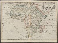
Africa distinguished into its principall parts viz. Barbary, Biledulgerid, Egypt, Zaara or the Desart, the Country of the Negroes, Guinea, Nubia, Abissinea, Zanguebar, Congo, Monomotapa, Caffrares, the Islands of the Canaries, Cape Verd, St. Thomas, Madagascar or St. Lawrence in which are observed the empires, monarchies, kingdomes, states and peoples, which at present inhabite Africa
Description:
Ferro meridian., No. 56 of 69 maps bound together in composite atlas., Relief shown pictorially., Scale [ca 1:34 000 000]., and To the most serene and most sacred majesty of Charles II, by the grace of God, king of Great Brittain, France, and Ireland, this map of Africa is humbly dedicated and presented by your majesties loyal subject and servant, William Berry.
Publisher:
Sold by William Berry at the sign of the globe between Charing Cross and White-Hall
BEIN 90 1650: Sheet measures 42 x 57 cm. Ms. no. on recto: 7[?]. Stamp on verso: Karpinski-von Wieser Map Collection., "Auec priuilege du Roy pour 20 ans"., and From Sanson's Cartes générales de toutes les parties du monde (1658).
Publisher:
Chez l'autheur, et chez Pierre Mariette, rue St. Iacques a l'Esperance ...
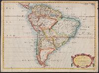
"Dedié au Roy parson très humble, très obeissant, très fidele sujet et serviteur Hubert Jaillot geographe de sa Majesté.", Appears in Jaillot's Atlas françois., Hand colored borders. Sheet measures 54.2 x 77.6 cm., Includes eight bar scales., Prime meridian: Ferro., Relief shown pictorially., and Watermark.
Publisher:
Chez H. Iaillot joignant les Grands Augustins aux deux Globes avec privilege du Roy, pour vignt ans,
Subject (Geographic):
South America--Maps--Early works to 1800
Subject (Name):
Albany Institute Stamp, Cordier, Louis, -1711, engraver, and Jaillot, Alexis Hubert, 1632?-1712. Atlas françois
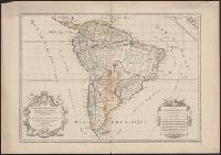
Covers area from northern South America to Greenland and includes the British Isles and the Azores., McLaughlin third state, with Lake Ontario shaded. Mounted on board. Sheet measures 47 x 61 cm. Ms. nos. on recto: 42, 28., Relief shown pictorially., and Shows C
Publisher:
Chez l'autheur, et chez Pierre Mariette, rue S. Iacques a l'Esperāce,
Subject (Geographic):
North America--Maps--Early works to 1800
Subject (Name):
Mariette, Pierre, 1603-1657 and Peyrounin, A., engraver
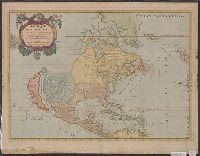
Appeared in Guillaume Sanson's Cartes générales de toutes les parties du monde., Cross collection no. 20., Differs from the 1650 Sanson map in its detail of the Gulf of California and its labeling of oceans--LVA web site., Imperfect: mutilated, with some loss of text. Mounted on linen., No. 1 of 3 maps mounted on linen., Relief shown pictorially., Shows California as an island. Includes the Southwest and Mexico., and Watermark.
Publisher:
Chez Pierre Mariette, ruë St. Jacques à l'Espera[n]ce, avec privilege de Sa Mai[es]té pour 20-äns,
Subject (Geographic):
North America--Maps--Early works to 1800
Subject (Name):
Mariette, Pierre, 1634-1716 and Sanson, Guillaume. Cartes générales de toutes les parties du monde
Appeared in Guillaume Sanson's Cartes générales de toutes les parties du monde., Imperfect: mutilated, with some loss of text. Mounted on linen. Sheet measures 43 x 59 cm. Cross collection no. 20. No. 1 of 3 maps mounted on linen., Mounted on cardboard. Sheet measures 46.3 x 59.8 cm. Cross collection no. 141., Relief shown pictorially., Shows California as an island. Includes the Southwest and Mexico., and Watermark.
Publisher:
Chez Pierre Mariette, ruë St. Jacques à l'Espera[n]ce, avec privilege de Sa Mai[es]té pour 20-äns,
Subject (Geographic):
North America--Maps--Early works to 1800
Subject (Name):
Mariette, Pierre, 1634-1716 and Sanson, Guillaume. Cartes générales de toutes les parties du monde
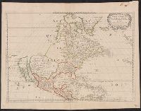
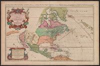
L'Amerique septentrionale divisée en ses principales parties, sçauoir les terres arcticques, le Canada ou Nouvelle France, le Mexique ou Nouvelle Espagne, le Nouveau Mexique, les isles de Terre Neuve, de Californie, et Antilles ou sont distingués les u
Description:
"Auec priuilege du Roy pour vingt ans.", "Presentée a Monseigneur le Davphin, parson tres humble, tres-obeissant, et tres fidele seruiteur, Hubert Iaillot.", Appears in Jaillot's Atlas françois., Prime meridian: Ferro., Relief shown pictorially., and Shows Calif
Publisher:
Chez H. Iaillot joignant les grands Augustins aux deux globes,
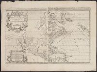
Amérique Septentrionale, divisée en ses principales parties ... les Terres Arcticques, le Canada ou Nouvelle-France, le Mexique ou Nouvelle Espagne, le Nouveau Mexique, les Isles de Terre Neuve, de Californie, et Antillis ou sont distingues les uns des
Description:
Date from upper right margin; "1674" listed in lower left cartouche., Includes eight bar scales., Relief shown pictorially., Similar to McLaughlin, G. Mapping of California as an island, 55 and Lowery 169., Stamp on verso: Yale, Horace Brown, 1900S., and Watermark
Publisher:
Chez H. Iaillot, joignant les grands Augustins aux deux Globs., avec privilege du Roy pour vingt ans,