Skip to search
Skip to main content
Skip to first result
Search
You Searched For
Extent of Digitization
Partially digitized
Genre
Atlases
Resource Type
Maps, Atlases & Globes
New Search
Search Results
Creator:
Published / Created:
1741
Call Number:
1978 Folio 106
Collection Title:
Maps of the Orinoco-Essequibo region, South America. Compiled for the Commission appointed by the
Image Count:
1
Resource Type:
Maps, Atlases & Globes
Subject (Geographic):
Caribbean Area--Maps--Early works to 1800, Colombia --Maps, Orinoco River Valley (Venezuela and Colombia) --Maps, and Venezuela --Maps
Collection Created:
Washington, 1897
Found in:
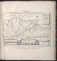
Beinecke Rare Book and Manuscript Library > Map of the Jesuit missions of New Granada, by father Joseph Gumilla, S. J., Madrid, 1741
Published / Created:
1778
Call Number:
1978 Folio 106
Collection Title:
Maps of the Orinoco-Essequibo region, South America. Compiled for the Commission appointed by the
Image Count:
1
Resource Type:
Maps, Atlases & Globes
Subject (Geographic):
Caribbean Area--Maps--Early works to 1800, Orinoco River Valley (Venezuela and Colombia) --Maps, South America --Maps --Early works to 1800, and Venezuela --Maps
Collection Created:
Washington, 1897
Found in:
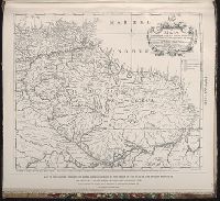
Beinecke Rare Book and Manuscript Library > Map of the Spanish privince of Nueva Andalucia made at the order of the head of the Spanish Archive of the Indies by Luis de Surville, Assistant Archivist, 1778
Creator:
Published / Created:
[1840]
Call Number:
1973 Folio 105
Collection Title:
Atlas fisico y politico de la Republica de Venezuela ... por ... Agustin Codazzi ...
Image Count:
1
Resource Type:
Maps, Atlases & Globes
Description:
Double page width, tab mounted. and Lith. de Thierry Fres. Cite Bergere 1 a Paris, printers.
Subject (Geographic):
Orinoco River Valley (Venezuela and Colombia), Venezuela --Description and travel, and Venezuela --Maps
Subject (Topic):
Physical geography --Venezuela
Collection Created:
Caracas,
Found in:
Beinecke Rare Book and Manuscript Library > Mapa de las costas de Tierra-Firme desde el Orinoco hasta Yucatan: de las islas Antillas y la mayor parte de las Lucayas, con las derrotas que siguio Dn. Cristobal Colon en sus descubrimientos por estos mares y las derrotas de otros navegantes que reconoc
Creator:
Published / Created:
[1840]
Call Number:
1973 Folio 105
Collection Title:
Atlas fisico y politico de la Republica de Venezuela ... por ... Agustin Codazzi ...
Image Count:
1
Resource Type:
Maps, Atlases & Globes
Alternative Title:
Mapa fisico de Venezuela, divida en tres zonas
Description:
Double page width, tab mounted. and Lith. de Thierry Fres. Cite Bergere 1 a Paris, printers.
Subject (Geographic):
Orinoco River Valley (Venezuela and Colombia), Venezuela --Description and travel, and Venezuela --Maps
Subject (Topic):
Physical geography --Venezuela
Collection Created:
Caracas,
Found in:
Beinecke Rare Book and Manuscript Library > Mapa fisico de Venezuela, divida en hoyas hydrograficas.
Creator:
Published / Created:
1832
Call Number:
1978 Folio 106
Collection Title:
Maps of the Orinoco-Essequibo region, South America. Compiled for the Commission appointed by the
Image Count:
1
Resource Type:
Maps, Atlases & Globes
Subject (Geographic):
Caribbean Area--Maps--Early works to 1800, Colombia --Maps, Guyana --Maps, Orinoco River Valley (Venezuela and Colombia) --Maps, and Venezuela --Maps
Collection Created:
Washington, 1897
Found in:
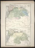
Beinecke Rare Book and Manuscript Library > Part of a map of Colombia by J. Arrowsmith, London, 1832
Creator:
Call Number:
Lxe2 +842s
Image Count:
2
Resource Type:
Maps, Atlases & Globes
Alternative Title:
Schulatlas über alle Teile der Erde
Description:
Contents (on title page) lists 27 maps numbered Ia-XX., Included are maps XXI-XXV, which form the supplement to the atlas; they are not listed in the Inhalt on t.p. but are also cited in the Nachricht., Relief shown by hachures., The subscriber to the 22d edition was allowed to order gratis, one map any from the publisher's Atlas der deutschen Bundes-Staaten which might make the entire work more useful to the teacher or pupil; this copy includes map VIII (Preussische Rhein-Provinz) and map IX (Preussische Provinz Westphalen) cf. Nachricht on t.p. verso., and Variations in numbering: no. XVIIb is used twice, for Ostindien mit den Inseln, and for Vorder-Asien und Nil-Land; XIXb is repeated, for Vereinigte Staaten von Nord-America und Canada, and for Vereinigte Staaten von Nord-America und Mexico.
Subject (Geographic):
Germany (East)--Maps and Germany, Northern--Maps
Subject (Topic):
Atlases, German
Found in:
Beinecke Rare Book and Manuscript Library > Schul-Atlas über alle Theile der Erde nach dem neuesten Zustande, und über das Weltgebäude : nach Stieler's Hand-Atlas verkleinert.
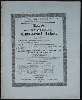
Published / Created:
1833
Call Number:
2002 Folio 97
Collection Title:
Tanner’s universal atlas : subscription price $1.00 a number, seperate [sic] numbers $1.50 each
Image Count:
1
Resource Type:
Maps, Atlases & Globes
Description:
Verso blank.
Collection Created:
Philadelphia : Published by the author, 1833-1836
Found in:
Beinecke Rare Book and Manuscript Library > Tanner's universal atlas ... of a new and elegant universal atlas
Creator:
Published / Created:
[1840]
Call Number:
1973 Folio 105
Collection Title:
Atlas fisico y politico de la Republica de Venezuela ... por ... Agustin Codazzi ...
Image Count:
1
Resource Type:
Maps, Atlases & Globes
Description:
Caption from index., Double page width, tab mounted., and Lith. de Thierry Fres. Cite Bergere 1 a Paris, printers.
Subject (Geographic):
Venezuela --Statistics
Subject (Topic):
Mountains --Venezuela, Physical geography --Venezuela, and Rivers --Venezuela
Collection Created:
Caracas,
Found in:
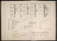
Beinecke Rare Book and Manuscript Library > Un cuadro de alturas que comprende las de las cordilleras de Merida, de la costa de Caracas, Coro, Cumana y Margarita, y ultimamente las del sistema de la Parima. Otro cuadro comparativo de la superficie y poblacion de cada provincia. Otro de los principa
Creator:
Published / Created:
[1840]
Call Number:
1973 Folio 105
Collection Title:
Atlas fisico y politico de la Republica de Venezuela ... por ... Agustin Codazzi ...
Image Count:
9
Resource Type:
Maps, Atlases & Globes
Description:
Lith. de Thierry Fres. Cite Bergere 1 a Paris, printers.
Subject (Geographic):
Venezuela --Description and travel and Venezuela --Maps
Subject (Topic):
Physical geography --Venezuela
Collection Created:
Caracas,
Found in:
Beinecke Rare Book and Manuscript Library > [Illustrated title page and selected text]
Creator:
Published / Created:
[1840]
Call Number:
1973 Folio 105
Collection Title:
Atlas fisico y politico de la Republica de Venezuela ... por ... Agustin Codazzi ...
Image Count:
1
Resource Type:
Maps, Atlases & Globes
Alternative Title:
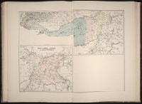
Carta del Canton de Caycara de la provincia de la Guayana
Description:
Double page width, tab mounted. and Lith. de Thierry Fres. Cite Bergere 1 a Paris, printers.
Subject (Geographic):
Apure (Venezuela)--Maps, Bolivar (Venezuela : State)--Maps, Guayana Region (Venezuela)--Maps, Orinoco River Valley (Venezuela and Colombia), and Venezuela --Maps
Subject (Topic):
Physical geography --Venezuela
Collection Created:
Caracas,
Found in:
Beinecke Rare Book and Manuscript Library > [Provincia de Apure]
Branch:v1.61.8 ,Deployed:2024-06-20T11:15:04-04:00